Hont County

Last updated

Hont County
Comitatus Hontiensis (Latin)
Hont vármegye (Hungarian)
Komitat Hont (German)
Hontianska župa (Slovak)
County of the Kingdom of Hungary
11th century–1923
Coa Hungary County Hont (history).svg
Coat of arms
Hont.png
Capital Hont; Németi (1619-1629); Korpona; Kemence; Ipolyság (1806-1920); Nagymaros (1920-1923)
Area
  Coordinates 48°4′N18°57′E / 48.067°N 18.950°E / 48.067; 18.950
 
 1910
2,633 km2 (1,017 sq mi)
Population 
 1910
132,441
History 
 Established
11th century
 Treaty of Trianon
4 June 1920
 Merged into Nógrád-Hont County
1923
Today part of Slovakia
(2,171 km2)
Hungary
(462 km2)
Šahy is the current name of the capital.

Hont County [lower-alpha 1] was an administrative county (comitatus) of the Kingdom of Hungary. Most of its territory is now part of Slovakia, while a smaller southern portion is part of Hungary.

Contents

Today, in Slovakia Hont is the informal designation of the corresponding territory and an official tourist region.

Geography

Map of Hont, 1891. Hont county map.jpg
Map of Hont, 1891.
Map of the Hont county, 1782-1785 Gros Honter County Josephinische Landesaufnahme, 1782-85.jpg
Map of the Hont county, 1782–1785

Hont county shared borders with the counties Bars, Zólyom, Nógrád, Pest-Pilis-Solt-Kiskun and Esztergom. It was situated between Selmecbánya and the Danube river, but the territory around the town of Korpona was added only at the end of the 19th century. The rivers Korpona and Ipoly were the central rivers that flowed through the county. Its area was 2633 km2 around 1910.

Capitals

The capitals of the county were the Hont Castle together with Hídvég (present-day Ipeľské Predmostie), then from the 16th century onwards there was no permanent capital, and finally since early 19th century, the capital was Ipolyság (present-day Šahy).

History

The county arose in the 11th century by separation from the Nógrád county. Around the year 1300, the territory of Kishont was added to the territory of the county, but received a special status.

From 1552 to 1685, most of the county was part of the Ottoman Empire and belonged to the administrative unit called Nógrád sandjak.

Changes to the northern border of the county were performed in 1802 (Kishont became part of the Gömör-Kishont county) and then in the late 19th century (above all Korpona was added to the territory).

In the aftermath of World War I, most of Hont county became part of newly formed First Czechoslovak Republic (Czechoslovakia), as recognized by the concerned states in 1920 by the Treaty of Trianon. A small part of the county situated south-east of the river Ipoly/Ipeľ, stayed in Hungary.

In Czechoslovakia, the county continued to exist as the Hont county (Hontianska župa). In 1923, it became part of the Zvolen county. The Hungarian part of Hont merged with the Hungarian part of Nógrád county to form Nógrád-Hont county in 1923.

In 1928, it became part of the newly created Slovak Land (Slovenská krajina/zem). After the First Vienna Award, between 1938 and 1945, it was united with the redeemed parts of former Bars and Hont counties to form Bars-Hont county with the capital of Léva. The remaining northern part became part of the newly created Hron county (1940–1945) of the Slovak Republic. After World War II, the Trianon borders were restored and Nógrád-Hont County was reformed on her remnants in Hungary. In 1949, the Czechoslovak part became part of the newly created Nitra region and Banská Bystrica region of Czechoslovakia (Fourth Czechoslovak Republic), while the Hungarian part was eventually merged into newly formed Pest County in 1950. In 1960, the Czechoslovak part became part of the newly created Western Slovak  [ sk ] and Central Slovak regions  [ sk ]. In 1993, Czechoslovakia was split and in 1996 its territory became part of the newly created Nitra and Banská Bystrica regions of Slovakia.

Demographics

Ethnic map of the county with data of the 1910 census (see the key in the description). Hont ethnic map.png
Ethnic map of the county with data of the 1910 census (see the key in the description).
Population by mother tongue [lower-alpha 2]
CensusTotal Hungarian Slovak German Other or unknown
1880 [1] 116,08049,170 (43.83%)54,484 (48.56%)7,952 (7.09%)590 (0.53%)
1890 [2] 123,02358,155 (47.27%)56,529 (45.95%)7,602 (6.18%)737 (0.60%)
1900 [3] 130,73465,522 (50.12%)57,315 (43.84%)7,051 (5.39%)846 (0.65%)
1910 [4] 132,44173,215 (55.28%)51,522 (38.90%)6,417 (4.85%)1,287 (0.97%)
Population by religion [lower-alpha 3]
CensusTotal Roman Catholic Lutheran Calvinist Jewish Other or unknown
1880116,08079,044 (68.09%)26,397 (22.74%)7,565 (6.52%)2,908 (2.51%)166 (0.14%)
1890123,02384,983 (69.08%)26,892 (21.86%)7,813 (6.35%)3,199 (2.60%)136 (0.11%)
1900130,73491,965 (70.35%)26,845 (20.53%)8,437 (6.45%)3,305 (2.53%)182 (0.14%)
1910132,44194,896 (71.65%)25,785 (19.47%)8,339 (6.30%)3,180 (2.40%)241 (0.18%)

Subdivisions

Hont county administrative map.jpg

Until 1802, the county consisted of 3 processuses (in Slovak slúžnovské okresy; a type of districts led by "iudices nobilium") plus the Kishont district. In 1802, when Kishont was removed, the county was divided in four new processus.

In the early 20th century, the subdivisions of Hont county were:

Districts (járás)
DistrictCapital
  BátBát (now Bátovce)
  IpolynyékIpolynyék (now Vinica)
  IpolyságIpolyság (now Šahy)
  KorponaKorpona (now Krupina)
  Szob Szob
Vámosmikola (from 1907) Vámosmikola
  Urban counties (törvényhatósági jogú város)
Selmec- és Bélabánya (now Banská Štiavnica and Banská Belá)
  Urban districts (rendezett tanácsú város)
Korpona (now Krupina)

The towns of Vámosmikola and Szob are now in Hungary.

See also

Notes

  1. Hungarian: Hont vármegye, Honth; Latin: Comitatus Hontiensis, Honthum; German: Komitat Hont; Slovak: Hontianska župa
  2. Only linguistic communities > 1% are displayed.
  3. Only religious communities > 1% are displayed.

Related Research Articles

<span class="mw-page-title-main">Liptó County</span> County of the Kingdom of Hungary

Liptó County was an administrative county (comitatus) of the Kingdom of Hungary. Its territory is now in northern Slovakia.

<span class="mw-page-title-main">Zemplén County</span> County of the Kingdom of Hungary

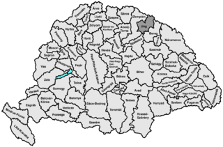
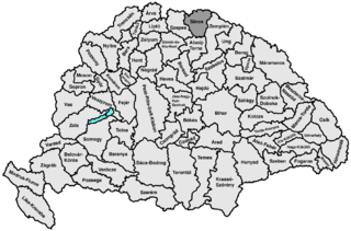
Zemplén was an administrative county (comitatus) of the Kingdom of Hungary. The northern part of its territory is now situated in eastern Slovakia, while a smaller southern portion of the former county belongs to Hungary, as part of Borsod-Abaúj-Zemplén County.

<span class="mw-page-title-main">Bars County</span> County of the Kingdom of Hungary

Bars was an administrative county (comitatus) of the Kingdom of Hungary. Its territory is now in central and southern Slovakia. Today in Slovakia, Tekov is the informal designation of the corresponding territory.

<span class="mw-page-title-main">Turóc County</span> County of the Kingdom of Hungary

Turóc, Slovak: Turiec, Latin: Thurotzium/comitatus Thurociensis, German: Turz) was an administrative county (comitatus) of the Kingdom of Hungary. Its territory is now in north-western Slovakia, where the corresponding Slovak name Turiec is only an informal designation of the corresponding territory.

<span class="mw-page-title-main">Esztergom County</span> County of the Kingdom of Hungary

Esztergom County was an administrative county of the Kingdom of Hungary, situated on both sides of the Danube river. Its territory is now divided between Hungary and Slovakia. The territory to the north of the Danube is part of Slovakia, while the territory to the south of the Danube is part of Hungary.

<span class="mw-page-title-main">Pozsony County</span> County of the Kingdom of Hungary

Pozsony county was an administrative county (comitatus) of the Kingdom of Hungary. Its territory is now mostly part of Slovakia, while a small area belongs to Hungary. In 1969, the three villages that remained in Hungary were combined to form Dunasziget.

<span class="mw-page-title-main">Nyitra County</span> County of the Kingdom of Hungary

Nyitra County was an administrative county (comitatus) of the Kingdom of Hungary. Its territory lay in what is now western Slovakia.

<span class="mw-page-title-main">Heves County (former)</span> Administrative county in the Kingdom of Hungary

Heves was an administrative county in the Kingdom of Hungary. Its territory, which is now in northern Hungary, was slightly larger than that of present Heves county. The capital of the county was Eger.

<span class="mw-page-title-main">Trencsén County</span> County of the Kingdom of Hungary

Trencsén county was an administrative county (comitatus) of the Kingdom of Hungary. Its territory is now in western Slovakia.

<span class="mw-page-title-main">Zólyom County</span> County of the Kingdom of Hungary

Zólyom county was an administrative county (comitatus) of the Kingdom of Hungary. Its territory is now in central Slovakia.

<span class="mw-page-title-main">Borsod County</span> County of the Kingdom of Hungary

Borsod was an administrative county (comitatus) of the Kingdom of Hungary. The capital of the county was Miskolc. After World War II, the county was merged with the Hungarian parts of Abaúj-Torna County and Zemplén counties to form Borsod-Abaúj-Zemplén county.

<span class="mw-page-title-main">Ung County</span> County of the Kingdom of Hungary

Ung County was an administrative county (comitatus) of the Kingdom of Hungary. Its territory is now mostly in western Ukraine, a smaller part in eastern Slovakia, and a very small area in Hungary.

<span class="mw-page-title-main">Máramaros County</span> County of the Kingdom of Hungary

Máramaros County was an administrative county (comitatus) of the Kingdom of Hungary. Its territory is now in north-western Romania and western Ukraine. The capital of the county was Máramarossziget.

<span class="mw-page-title-main">Szabolcs County</span> County of the Kingdom of Hungary

Szabolcs was an administrative county (comitatus) of the Kingdom of Hungary. Its territory is now part of Hungary, except for three villages which are in the Zakarpattia Oblast of Ukraine. The capital of the county was Nyíregyháza.

<span class="mw-page-title-main">Ugocsa County</span> County of the Kingdom of Hungary

Ugocsa was an administrative county (comitatus) of the Kingdom of Hungary. Its territory is now in north-western Romania and western Ukraine. The capital of the county was Nagyszőllős.

<span class="mw-page-title-main">Fogaras County</span>

Fogaras was an administrative county (comitatus) of the Kingdom of Hungary. Its territory is now in central Romania. The county's capital was Fogaras.

<span class="mw-page-title-main">Árva County</span> County of the Kingdom of Hungary

Árva County was an administrative county (comitatus) of the Kingdom of Hungary since the 14th century until 1920. Its territory is now in northern Slovakia and southern Poland. Today, the Slovak name is only used as an informal designation of the corresponding territory.

<span class="mw-page-title-main">Gömör and Kishont County</span> County of the Kingdom of Hungary

Gömör-Kishont was an administrative county (comitatus) of the Kingdom of Hungary. Its capital was Rimaszombat. Most of its territory is now part of Slovakia, while a smaller part belongs to Hungary.

<span class="mw-page-title-main">Nógrád County (former)</span> County of the Kingdom of Hungary

Nógrád was an administrative county of the Kingdom of Hungary. Its territory is now divided between Hungary and Slovakia. The name Novohrad is still used in Slovakia as an informal designation of the corresponding territory. The name is derived from the former Nógrád castle in Hungary.

<span class="mw-page-title-main">Sáros County</span> County of the Kingdom of Hungary

Sáros was an administrative county (comitatus) of the Kingdom of Hungary. Its territory is now in northeastern Slovakia. Today, Šariš is only an informal designation of the corresponding territory.

References

  1. "Az 1881. év elején végrehajtott népszámlálás főbb eredményei megyék és községek szerint rendezve, II. kötet (1882)". library.hungaricana.hu. Retrieved 28 September 2021.
  2. "A Magyar Korona országainak helységnévtára (1892)". library.hungaricana.hu. Retrieved 29 September 2021.
  3. "A MAGYAR KORONA ORSZÁGAINAK 1900". library.hungaricana.hu. Retrieved 29 September 2021.
  4. "KlimoTheca :: Könyvtár". Kt.lib.pte.hu. Retrieved 29 September 2021.