

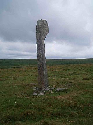
Hookney Tor is a tor, situated on Dartmoor in Devon, England.
Contents
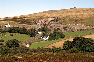
It lies on the Two Moors Way and remains of Headland Warren farm and Vitifer Mine are also in the valley nearby.
Hookney Tor is a tor, situated on Dartmoor in Devon, England.
It lies on the Two Moors Way and remains of Headland Warren farm and Vitifer Mine are also in the valley nearby.
Hookney Tor is named after the nearby settlement of Hookner. [1]
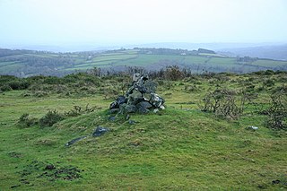
Hookney Tor is a hill and tor in Dartmoor National Park in South West England. It consists of several granite piles and stands at an elevation of 497 metres (1631 feet) above sea level. It has a descent of 22 metres. [2]
The tor is surrounded by the Hookney Tor Cairn in the form of discrete cluster mounds running along the ridge. This includes a rubble bank attached to its southern face. The ring bank survives in a D-shape. The tor itself is 6 metres wide and up to 0.9 metres high. [3]
Hookney Tor is situated in Dartmoor in Devon, England, amidst the Bronze Age settlement of Grimspound to the southeast, Hameldown to the south, Shapley Tor to the north, Birch Tor to the west, and King Tor to the east. [1]
The nearest town is Ashburton 11 miles to the southeast. [4] The nearest village is Widecombe-in-the-Moor several miles to the south.

Dartmoor is an upland area in southern Devon, South West England. The moorland and surrounding land has been protected by National Park status since 1951. Dartmoor National Park covers 954 km2 (368 sq mi).

A tor enclosure is a prehistoric monument found in the southwestern part of Great Britain. These monuments emerged around 4000 BCE in the early Neolithic.
Drizzlecombe or Thrushelcombe is an area of Dartmoor in the county of Devon, England, containing a number of Bronze Age stone rows, cairns and menhirs.
Merrivale is a locality in western Dartmoor, in the West Devon district of Devon, England. It is best known for the nearby series of Bronze Age megalithic monuments to the south and a former granite quarry.

High Willhays, or according to some authorities High Willes, is the highest point on Dartmoor, Devon, at 621 metres above sea level, and the highest point in Southern England.
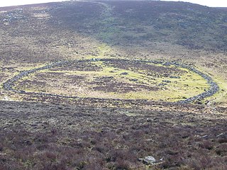
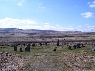
Grimspound is a late Bronze Age settlement, situated on Dartmoor in Devon, England. It consists of a set of 24 hut circles surrounded by a low stone wall. The name was first recorded by the Reverend Richard Polwhele in 1797; it was probably derived from the Anglo-Saxon god of war, Grim.

Hound Tor is a tor on Dartmoor, Devon, England and is a good example of a heavily weathered granite outcrop. It is easily accessible, situated within a few minutes from the B3387 between Bovey Tracey and Widecombe-in-the-Moor.

Crockern Tor is a tor in Dartmoor National Park, Devon, England. Composed of two large outcrops of rock, it is 396 metres above sea level. The lower outcrop was the open-air meeting place of the Stannary Convocation of Devon from the early 14th century until the first half of the 18th century. On Parliament Rock, pictured here, the Lord Warden of the Great Court of the Devon Tinners supposedly sat during meetings of the Court.

Bury Hill is the site of a former Iron Age hillfort about 1.5 miles (2.4 km) southwest of the centre of Andover, Hampshire. The site encloses about 22 acres (8.9 ha). There are evident two stages to the construction of the fort, the first is a low single rampart and ditch, to the north and west of the second, stronger double rampart and ditch earthworks, part of which overlies the earlier work. The banks and the ditch are apparently in good condition, although fairly heavily wooded. A footpath encircles the hill fort on the inner rampart, accessible from the northeast and southwest. The centre is left to grass and very secluded, but is not accessible to the general public. The site was used well into the Roman era and was used as a camp by King Canute in 1016, when he fought Edmund Ironside in the Battle of Andover.
Knoll Camp, or Damerham Knoll, is the site of an Iron Age univallate hill fort located in Hampshire. The fort comprises a circular earthwork containing about four acres. There is a single ditch with inner rampart and traces of counter scarp bank. The site is a scheduled ancient monument no.118. Grim's Ditch also runs throughout this area. The footpath/bridleway from the nearby long barrows of Grans Barrow and Knap Barrow runs southeast along the ridge through the centre of the hill fort, leaving through the original SE entrance, and you could easily miss the ditch and bank as you cross it. The interior is thickly wooded and brambled.

Bussock Camp is the site of an Iron Age bivallate hillfort located in Berkshire, England. It has a double bank and ditch to the south and east, with only a single bank remaining the north and western sides. The entrance is to the north of the site and is believed to be original, and the site encloses approximately 11 acres.
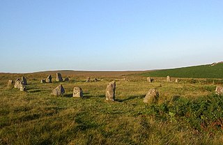
ScorhillStone Circle is now the commonly known name for Gidleigh Stone Circle or Steep Hill Stone Circle, one of Devon's biggest and most intact stone circles, situated on Gidleigh Common near the village of Gidleigh in the north east of Dartmoor, in the United Kingdom. It is an English Heritage scheduled monument and has been described as Devon's finest stone circle.
Goodaver, Goodaver stone circle or Goodaver circle is a stone circle located in the parish of Altarnun, near Bolventor on Bodmin Moor in Cornwall.

North Bovey is a village and civil parish situated on the south-eastern side of Dartmoor National Park, Teignbridge, Devon, England, about 11 miles WSW of the city of Exeter and 1.5 miles SSW of Moretonhampstead. The village lies above the eastern bank of the River Bovey from which it takes its name. In 2001 the population of the parish was 274, compared to 418 in 1901 and 519 in 1801.
Brisworthy stone circle is a stone circle on Dartmoor, Devon. It is located three miles east of the A386, northeast of the village of Shaugh Prior. It is three hundred metres from Ringmoor stone row and cairn circle, and is one of the archaeological sites found in the Upper Plym Valley.
Cosdon Hill, also called Cosdon Beacon, or Cawsand Beacon, is one of the highest hills on Dartmoor, in Devon, England. It has numerous traces of prehistoric occupation.
Cut Hill is a hill in North Dartmoor in the southwest English county of Devon. At 603 metres high, it is the joint third highest peak in Devon and Dartmoor, together with Hangingstone Hill, which lies around 4 kilometres to the northeast.
Amicombe Hill, also known as the Devil's Dome, is a hill in North Dartmoor in the southwest English county of Devon. At 584 metres high, it is the sixth highest peak in Devon and Dartmoor.
Aish Tor is a small tor above the northern side of the Dart Gorge in Dartmoor, Devon, England, that is accessed by Dr. Blackall's Drive from Newbridge Hill. It stands at 283 metres (928 ft) above sea level and is topped by a small cairn. The actual 'tor' is small and flat and generally hard to pin-point. Nearby tors include:
Rattle Brook is a brook in north Dartmoor in Devon in south-west England. It is situated East of Great Links Tor, and rises by the Rattlebrook Peatworks on remote moorland in the western section of Dartmoor National Park. It flows past Bleak House with Green Tor to the east and Higher and Lower Dunna Goat Tors to the west. It runs between Amicombe Hill and Rattlebrook Hill to join the River Tavy at the mouth of Tavy Cleave.