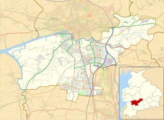
South Ribble is a non-metropolitan district and borough of Lancashire, England. Its council is based in Leyland. The population, at the 2011 Census, was 109,057.
In May 2007, the council was officially declared "Excellent" by the Audit Commission, of the best five district councils in the country. The council is the only district council not to be part of the District Councils' Network.
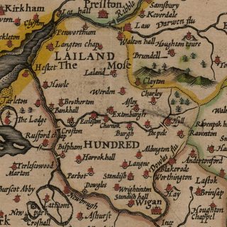
The Leyland Hundred is a historic subdivision of the English county of Lancashire. It covered the parishes of Brindle, Chorley, Croston, Eccleston, Hoole, Leyland, Penwortham, Rufford, Standish and Tarleton.

Great Altcar is a village and civil parish in West Lancashire, England, close to Formby on the West Lancashire Coastal Plain. The population as taken at the 2011 census was 213. The name Altcar is Norse meaning "marsh by the Alt". The church of St Michael and All Angels is a timber framed structure dating from 1879.

Elton is a village and civil parish in the unitary authority of Cheshire West and Chester and the ceremonial county of Cheshire, England. It is situated approximately 13 km (8.1 mi) to the northeast of Chester, between Helsby and Ellesmere Port, near to the River Mersey. Its proximity to the River Mersey and the Manchester Ship Canal have contributed to its industrial character. The village is on the north-western edge of the Cheshire plain, approximately 2.5 km (1.6 mi) from Stanlow Refinery, a Shell facility and the seventh largest oil refinery in Europe. The refinery produces one-sixth of the United Kingdom's petrol.
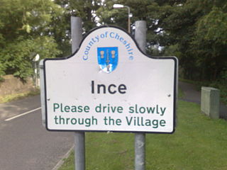
Ince is a village and civil parish in the unitary authority of Cheshire West and Chester and the ceremonial county of Cheshire, England. It is situated immediately to the east of the Stanlow Oil Refinery. It shares Ince & Elton railway station with the village of Elton, which it runs into. According to the 2001 Census, it was recorded as having a population of 209.

Barrow is a civil parish containing the villages of Great Barrow, Little Barrow and Stamford Bridge. It is situated about 4.5 miles east-north-east of Chester, 6 miles north-west of Tarporley, and 6 miles south of Frodsham.

Mollington is a small village and civil parish in the unitary authority of Cheshire West and Chester and the ceremonial county of Cheshire, England. It is located two miles north of the city of Chester, with approximate boundaries formed by the A41 Liverpool-Chester trunk road and Shropshire Union Canal to the east and southeast, the A540 Wirral Peninsula trunk road to the south and west and the A5117 Dunkirk link road to the north. According to the 2001 census, the village has a population of 663, reducing to 626 at the 2011 Census.
The total ward population, which includes the nearby settlements of Backford, Capenhurst, Ledsham and Wervin, was 2,077. This ward had been combined with Saughall by the time of the 2011 Census.(qv)

Little Sutton is a village in north west Cheshire, England, located between Childer Thornton and Great Sutton. It is a suburb of the town of Ellesmere Port and part of the unitary authority of Cheshire West and Chester.
Rixton-with-Glazebrook is a civil parish in the unitary authority of Warrington, Cheshire, England. Historically part of Lancashire, it lies to the east of Warrington and borders Cadishead, and is largely farmland. It has a railway station at Glazebrook and is served by buses along the A57 road. The parish was originally a township within Warrington parish before becoming a separate parish in 1866. It was part of the Warrington Poor Law Union and, from 1894, Warrington Rural District, and the District of Warrington from 1974.
Ledsham is a village and civil parish in the unitary authority of Cheshire West and Chester and the ceremonial county of Cheshire, England. It is located on the Wirral Peninsula, to the north of Capenhurst and to the west of Ellesmere Port. The village includes parts of the hamlets of Badger's Rake and Two Mills, and has a population of 88, increasing to 181 at the 2011 census.
Chorley is a civil parish in the unitary authority of Cheshire East and the ceremonial county of Cheshire, England. The parish itself contains no large settlement, but there is a small hamlet called Row-of-Trees in the north of the parish. According to the 2001 census, the population of the parish was 399, increasing to 496 at the 2011 Census.
Mickle Trafford is a village and former civil parish, now in the parish of Mickle Trafford and District, in the unitary authority of Cheshire West and Chester and the ceremonial county of Cheshire, England. It includes the area known as Plemstall. In 2004 the population of the civil parish was estimated to be 2,140, although the 2001 census recorded 1,831 people. The A56 road from Chester to Warrington passes through the village and the Chester-Warrington railway line passes immediately to its east. The civil parish was abolished in 2015 to form Mickle Trafford and District, part of it also went to Guilden Sutton.

Hampton is a former civil parish, now in the parishes of No Man's Heath and District and Malpas, in the unitary authority of Cheshire West and Chester and the ceremonial county of Cheshire, England. According to the 2001 UK census, the total population of the civil parish was 409, decreasing marginally to 405 at the 2011 Census. The parish included Hampton Green. The civil parish was abolished in 2015 to form No Man's Heath and District, part of it also went to Malpas.
Walmer Bridge is a small village in Lancashire, England. Surrounding villages are Much Hoole and Longton.

Barton is a small village in the county of Lancashire, England. It is situated approximately 4 miles (6 km) west from Ormskirk, and less than 1 mile (2 km) west from the A5147 road. Barton sits on the West Lancashire Coastal Plain, and is 5 miles (8 km) from the Irish Sea coast. The village lies within the civil parish of Downholland.
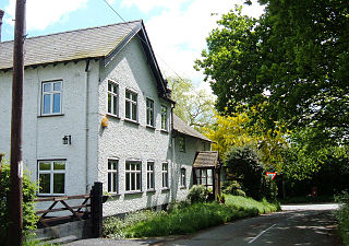
Little Hoole is a civil parish in the South Ribble district of Lancashire, England. It contains two listed buildings that are recorded in the National Heritage List for England. Both of the listed buildings are designated at Grade II, the lowest of the three grades, which is applied to "buildings of national importance and special interest". The parish contains the village of Walmer Bridge, and is otherwise rural, The listed buildings comprise a former manor house and a farmhouse, both dating from the 17th century.