Hope Mills Dam

Last updated
Hope Mills Dam
HopeMillsLakedrained.jpg
Hope Mills Dam and drained lake, June 2010
USA North Carolina relief location map.jpg
Red pog.svg
Location of Hope Mills Dam in North Carolina
Location Hope Mills, Cumberland County, North Carolina
Coordinates 34°58′20″N78°56′42″W / 34.97222°N 78.94500°W / 34.97222; -78.94500
StatusOperational
Construction began2007
Opening date2008
Construction cost$9.8 million
Owner(s)Town of Hope Mills
Dam and spillways
Type of dam Concrete gravity
ImpoundsLittle Rockfish Creek
Height33 ft (10 m) [1]
Length750 ft (230 m)
Spillway typeChute, labyrinth
Spillway capacity10,240 cu ft/s (290 m3/s) [1]
Reservoir
Creates Hope Mills Lake
Total capacity816 acre⋅ft (1,007,000 m3) [1]
Catchment area 94.4 sq mi (244 km2)
Surface area88 acres (0.36 km2)

The Hope Mills Dam, also known as Hope Mills Dam #1, is a concrete gravity dam on Little Rockfish Creek in Hope Mills, North Carolina, USA, which created Hope Mills Lake. Four different dams were built on the site including the current one. The first dam, of rock-crib design, was built in 1839 to power local cotton mills. The second was an embankment dam built in 1924 for powering the mills and later to maintain the lake's water level. Both previous dams failed from flooding. Then in June 2010 a leak was discovered and the lake was drained. The current dam was completed in early 2018 and water to be impounded in January but rainwater filled the dam before water even needed to be impounded.

Contents

History

The first Hope Mills Dam was a rock-crib dam and was built in 1839 by the Rockfish Mills Co. for the powering of four cotton mills nearby. [2] In 1865, General Sherman and Union Army troops burned the cotton mills but spared the dam from destruction. After the American Civil War, two mills were rebuilt and the surrounding area including the dam was named Hope Mills. [3] On May 9, 1923 this first dam was breached by a flood and construction on an earthen-embankment dam began the same year. Rockfish Mills Co. again constructed the dam with designs from Mees Consulting Engineers of Charlotte and the actual construction by the Scott-Stewart Jones Co. The second dam cost $27,093 and was completed in early 1924. [4]

In 1930, Rockfish Mills Co. went bankrupt and was not bought until 1941 by Dixie Yarns. Dixie Yarns eventually gave the dam to the town in 1984. [3] In 1993, a two-lane Lakeview Road bridge was installed over the dam and at the same time a leak in the dam was repaired. In 1994, an unused turbine shaft from the old cotton mill site was uncovered and filled with cement. In addition, walls behind the dam's spillway were reinforced with rock after concerns were voiced about their strength. Hurricane Floyd brought heavy rains in 1999 which, after concerns of a dam breach, forced the opening of the floodgates. In 2001, a 6-foot (1.8 m) crack was repaired that engineers had determined was not structural. Later in 2001, the dam passed safety inspection but two small holes and some eroded concrete was repaired in 2002. [4]

2003 failure and reconstruction

The reconstructed dam in 2010 Hope Mills Dam and Spillway high water.jpg
The reconstructed dam in 2010

In late May 2003, over Memorial Day weekend, heavy rains caused the embankment dam to give way and also destroyed 30 feet (9.1 m) of the nearby Lakeview Road. [4] About 40 homes and 1600 people downstream were evacuated as water from Hope Mills Lake rushed down the creek causing $2.1 million in damages before making its way to the Cape Fear River. One of the floodgates on the dam had failed to open because of the pressure exerted by the flood waters, which helped push water over the top of the dam. [5] Later in 2003, Lakeview Road was repaired and plans for the repair of the dam were underway. After four years of fund and permit requests, construction on the new 14 million dollar Hope Mills Dam began in March 2007. [6] Crowder Construction Company was awarded the contract to construct the dam along with designs from Mactec, Morrison Engineers. The new dam would essentially be a concrete labyrinth-spillway that would expand the dam's ability to discharge flood waters. The new dam would be 600 feet (180 m) longer and would incorporate a fish ladder as well. [7] [8] Construction of the new Hope Mills Dam was complete in June 2008 and the lake was again full by August. [8] [9]

Water passing through a sinkhole in the dam's foundation HopeMillsDamsinkhole.jpg
Water passing through a sinkhole in the dam's foundation

2010 failure

On Wednesday, June 16, 2010, a controlled release began after engineers noticed silt coming out of the lower side of the dam. Residents were informed to loosen the ropes to their boats because the lake was going to be lowered two feet. Town officials later told residents the lake may have to be lowered as much as nine feet to inspect the dam. Overnight a sinkhole developed at the base of the dam and the lake water drained underneath the foundation. By Thursday morning (June 17, 2010) almost all of the water in the lake was gone and the town awoke to a news helicopter hovering overhead with a live video feed to ABC11. [10] [11]

Repairs for the dam were expected to begin in August 2012 and end October 2013 but they never occurred. [12] A lawsuit was filed by the town in mid-October 2012, complaining that the companies involved were delaying the repairs which had yet to begin. [13] In April 2013 Mayor Jackie Warner requested a plan to remove the dam but the town sued the builders for $10 million in May in order to pay for repairs. [14] [15] In July 2014, the town received a $9.4 million settlement from the builders.

2016 Reconstruction

The reconstructed dam in 2018 Hope Mills Dam and Spillway high water 2018.jpg
The reconstructed dam in 2018

In March 2016, construction of a new dam started after years of frustration. The ribbon cutting for the completed dam was on 31 January 2018. [16] "but [s]teady rains ... filled the formerly empty lake bed to its proper level", Town Manager Melissa Adams said. As a result, the town shut the dam's gates, impounding the water in the lake. [17]

Envision Sustainability Award

On Wednesday, August 7, 2019, the Institute for Sustainable Infrastructure announced that the reconstructed Hope Mills Dam had been awarded an Envision Bronze award for sustainability. The project was the first dam project to earn an Envision award. [18] The project was completed by a design-build team composed of Schnabel Engineering and ASI Constructors with a budget of $8 million.

See also

Related Research Articles

<span class="mw-page-title-main">Dam</span> Barrier that stops or restricts the flow of surface or underground streams

A dam is a barrier that stops or restricts the flow of surface water or underground streams. Reservoirs created by dams not only suppress floods but also provide water for activities such as irrigation, human consumption, industrial use, aquaculture, and navigability. Hydropower is often used in conjunction with dams to generate electricity. A dam can also be used to collect or store water which can be evenly distributed between locations. Dams generally serve the primary purpose of retaining water, while other structures such as floodgates or levees are used to manage or prevent water flow into specific land regions.

<span class="mw-page-title-main">Hope Mills, North Carolina</span> Town in North Carolina, United States

Hope Mills is a town in Cumberland County, North Carolina, United States. Its population was 15,176 at the 2010 census.

<span class="mw-page-title-main">Garrison Dam</span> Dam in McLean/Mercer Counties, North Dakota

Garrison Dam is an earth-fill embankment dam on the Missouri River in central North Dakota, U.S. Constructed by the U.S. Army Corps of Engineers from 1947 to 1953, at over 2 miles (3.2 km) in length, the dam is the fifth-largest earthen dam in the world. The reservoir impounded by the dam is Lake Sakakawea, which extends to Williston and the confluence with the Yellowstone River, near the Montana border.

<span class="mw-page-title-main">Jordan Lake</span> Lake in North Carolina, U.S.

B. Everett Jordan Lake is a reservoir in New Hope Valley, west of Cary and south of Durham in Chatham County, North Carolina, in the United States; the northernmost end of the lake extends into southwestern Durham County.

<span class="mw-page-title-main">Spillway</span> Structure for controlled release of flows from a dam or levee

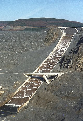
A spillway is a structure used to provide the controlled release of water downstream from a dam or levee, typically into the riverbed of the dammed river itself. In the United Kingdom, they may be known as overflow channels. Spillways ensure that water does not damage parts of the structure not designed to convey water.

<span class="mw-page-title-main">Oroville Dam</span> Dam in California

Oroville Dam is an earthfill embankment dam on the Feather River east of the city of Oroville, California, in the Sierra Nevada foothills east of the Sacramento Valley. At 770 feet (235 m) high, it is the tallest dam in the U.S. and serves mainly for water supply, hydroelectricity generation, and flood control. The dam impounds Lake Oroville, the second-largest reservoir in California, capable of storing more than 3.5 million acre-feet (1.1×10^12 US gal; 4.3×10⁹ m3).

<span class="mw-page-title-main">Painted Rock Dam</span> Dam in Maricopa County, Arizona, United States

The Painted Rock Dam is an earthfill embankment dam located west of Gila Bend, Arizona. It is primarily used for flood control purposes.

<span class="mw-page-title-main">Table Rock Lake</span> Man-made lake in Missouri and Arkansas, United States

Table Rock Lake is an artificial lake or reservoir in the Ozarks of southwestern Missouri and northwestern Arkansas in the United States. Designed, built and operated by the U.S. Army Corps of Engineers, the lake is impounded by Table Rock Dam, which was constructed from 1954 to 1958 on the White River.

<span class="mw-page-title-main">Fontana Dam</span> Dam in North Carolina, United States

Fontana Dam is a hydroelectric dam on the Little Tennessee River in Swain and Graham counties, North Carolina, United States. The dam is operated by the Tennessee Valley Authority, which built the dam in the early 1940s to satisfy the skyrocketing electricity demands in the Tennessee Valley to support the aluminum industry at the height of World War II; it also provided electricity to a formerly rural area.

<span class="mw-page-title-main">Saluda Dam</span> Dam in near Lexington, South Carolina

The Saluda Dam or Saluda River Dam, officially the Dreher Shoals Dam, commonly referred to as the Lake Murray Dam, is an earthen embankment dam located approximately 10 miles (15 km) west of Columbia, South Carolina on the Saluda River. Construction on the dam began in 1927 and was completed in 1930. The purpose of the dam is flood control, hydroelectricity, recreation and water supply. At the time of its completion, the Saluda Dam was the world's largest earthen dam, creating the world's largest man-made lake, Lake Murray. In 2005, construction on a 213 ft (65 m). tall roller-compacted concrete (RCC) dam was completed at the toe of the original dam in order to mitigate an earthquake-caused dam failure.

<span class="mw-page-title-main">Gavins Point Dam</span> Dam in Nebraska and Yankton County, South Dakota.

Gavins Point Dam is a 1.9 mi (3 km) long embankment rolled-earth and chalk-fill dam which spans the Missouri River and impounds Lewis and Clark Lake. The dam joins Cedar County, Nebraska with Yankton County, South Dakota a distance of 811.1 river miles (1,305 km) upstream of St. Louis, Missouri, where the river joins the Mississippi River. The dam and hydroelectric power plant were constructed as the Gavins Point Project from 1952 to 1957 by the United States Army Corps of Engineers as part of the Pick-Sloan Plan. The dam is located approximately 4 miles (6.4 km) west or upstream of Yankton, South Dakota.

<span class="mw-page-title-main">Canyon Lake (Texas)</span> Man-made reservoir in Texas, United States

Canyon Lake is a reservoir on the Guadalupe River in the Texas Hill Country in the United States. Canyon Lake is a U.S. Army Corps of Engineers reservoir formed on the Guadalupe River in Comal County by Canyon Dam, which is located about sixteen miles northwest of New Braunfels. The dam, lake, and all adjacent property are managed by the U.S. Army Corps Of Engineers. Water rights, waste water treatment, and hydroelectric generating facilities are managed by the Guadalupe-Blanco River Authority. Construction of the dam began in 1958 and was completed in 1964. The reservoir serves to provide flood control and water supply for the communities downstream from the dam. The lake is also a popular recreational destination.

<span class="mw-page-title-main">Lake Needwood</span> Reservoir in Derwood, Maryland

Lake Needwood is a 75-acre (300,000 m2) reservoir in Derwood, Maryland, United States. Located east of Rockville, in the eastern part of Montgomery County, it is situated on Rock Creek. The lake was created by damming Rock Creek in 1965 with the goal of providing flood control and reducing soil erosion. Lake Needwood also protects the water quality of the creek by functioning as a retention basin to trap sediment from storm-water runoff.

<span class="mw-page-title-main">Lake Livingston</span> Reservoir in Trinity and Walker Counties, Texas

Lake Livingston is a reservoir located in the East Texas Piney Woods. Lake Livingston was built and is owned and operated by the Trinity River Authority (TRA) of Texas under contract with the City of Houston for water-supply purposes. The USCG Auxiliary Flotilla 6-9 is also stationed on the lake. The lake is the third-largest lake located in the state of Texas. The Livingston Dam, constructed across the Trinity River about 7 miles (11 km) southwest of the city of Livingston is 2.5 miles (4 km) in length and has an average depth of 55 feet (17 m).

<span class="mw-page-title-main">Embankment dam</span> Type of artificial dam

An embankment dam is a large artificial dam. It is typically created by the placement and compaction of a complex semi-plastic mound of various compositions of soil or rock. It has a semi-pervious waterproof natural covering for its surface and a dense, impervious core. This makes the dam impervious to surface or seepage erosion. Such a dam is composed of fragmented independent material particles. The friction and interaction of particles binds the particles together into a stable mass rather than by the use of a cementing substance.

<span class="mw-page-title-main">Benbrook Lake</span> Reservoir in Tarrant County, Texas

Benbrook Lake is a reservoir on the Clear Fork of the Trinity River in Tarrant County, Texas, USA. The lake is located approximately 10 miles (16 km) southwest of the center of Fort Worth, where the Clear Fork and the West Fork of the Trinity River join. The lake is impounded by the Benbrook Dam. The lake and dam are owned and operated by the U.S. Army Corps of Engineers, Fort Worth District.

The Fairbairn Dam is an earth-filled embankment dam across the Nogoa River, located southwest of Emerald in Central Queensland, Australia. Constructed in 1972 for the primary purpose of irrigation, the impoundment created by the dam serves as one of the major potable water supplies for the region and assists with some flood mitigation.

<span class="mw-page-title-main">Hope Mills Lake</span> Reservoir in North Carolina, US

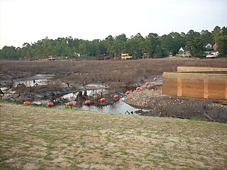
Hope Mills Lake, also referred to as Hope Mills Lake #1, and by long-time citizens as The Pond, was a lake in Hope Mills in Cumberland County, North Carolina. Before it was a lake, it was a mill pond which was fed by Little Rockfish Creek. The mill pond was created in 1839 near the Hope Mills Dam for the first cotton mill in the area. At the time, the area was called Little Rockfish Village. In 2003, heavy rains caused the earthen dam to fail and the lake was unintentionally drained. By 2006, the lake had not been restored so the Friends of Hope Mills Lake was incorporated as a North Carolina non-profit organization to promote and raise funds for the timely restoration and preservation of the dam. In 2008 the new dam was completed and full for the first time in 5 years. In June 2010, the Lake was intentionally drained for safety reasons, after an inspection discovered a sinkhole that was leaking water under the dam's structure.

<span class="mw-page-title-main">Delhi Dam</span> Dam in near Delhi, Iowa

Delhi Dam, also known as Hartwick Dam, is an embankment dam on the Maquoketa River 2.5 kilometres (1.6 mi) southwest of Delhi, Iowa that created Lake Delhi. The dam was over-topped and subsequently failed on July 24, 2010 after a period of heavy rain. It was rebuilt in 2016.

Success Dam is a dam across the Tule River in Tulare County, California in the United States. Serving mainly for flood control and irrigation, the dam is an earthen embankment structure 156 feet (48 m) high and 3,490 feet (1,060 m) long. The dam lies about 5 miles (8.0 km) east of Porterville and impounds Lake Success, which has a capacity of 82,300 acre-feet (0.1015 km3).

References

  1. 1 2 3 "North Carolina Dam Inventory - 10 August 2009". North Carolina Department of Environment and Natural Resources, Land Resource Division. Archived from the original on 2009-09-18. Retrieved 11 July 2010.
  2. Saskia L. Van De Gevel, Justin L. Hart, Henri D. Grissino-Mayer and Kenneth W. Robinson (2007-01-14). "Tree-Ring Dating Of Old-Growth Longleaf Pine (Pinus palustris Mill.) Logs From An Exposed Timber Crib Dam, Hope Mills, North Carolina, U.S.A". Tree-Ring Research. Tree-Ring Society. 65: 69–80. doi:10.3959/2007-14.1. hdl: 10150/622604 . S2CID   41237052 . Retrieved 2010-07-10.{{cite journal}}: CS1 maint: multiple names: authors list (link)
  3. 1 2 "Dam -- that may say it all in Hope Mills today". Fay Observer. 16 June 2010. Retrieved 11 July 2010.[ permanent dead link ]
  4. 1 2 3 M.S., Parkton (2010-06-23). "Live Wire: Previous Hope Mills dam was built in 1923". Fay Observer.com. Archived from the original on 2011-07-10. Retrieved 2010-07-10.
  5. "Hope Mills Dam bursts, forcing residents to evacuate". Herald Journal. Associated Press. 2003-05-25. Retrieved 2010-07-10.
  6. "Break in dam foundation material caused leak". ABC11.com. 2010-06-18.
  7. "Hope Mills Dam Repair". Morrison Engineers. Archived from the original on 2011-07-14. Retrieved 2010-07-10.
  8. 1 2 "Hope Mills to investigate dam failure". WRAL.com. 2010-06-21. Retrieved 2010-07-10.
  9. "Water drains from Hope Mills Lake again". WRAL.com. 2008-11-11. Retrieved 2010-07-10.
  10. "Water from Hope Mills Lake gone". ABC11.com. 2010-06-18.
  11. "Leaders meet to discuss dam failure". ABC11.com. 2010-06-21.
  12. Weber, Amanda (21 February 2012). "Hope Mills dam re-construction set to begin". TWEAN Newschannel of Raleigh, L.L.C. dba News 14 Carolina. Retrieved 22 February 2012.
  13. "Hope Mills files lawsuit over failed dam". WRAL. 16 October 2012. Retrieved 22 October 2012.
  14. Gillis, Stacey (3 April 2013). "Hope Mills board approves county mayors' plan for sales tax revenues". The Fayetteville Observer. Retrieved 29 April 2013.
  15. "North Carolina Town Files $10M Suit Over 2010 Dam Failure". Insurance Journal. 29 May 2013. Retrieved 30 May 2013.
  16. "Hope Mills Lake glistens at ceremonial ribbon cutting for dam".
  17. "Hope Mills Lake makes an early appearance".
  18. "Hope Mills Dam in North Carolina First Dam to Earn Envision Award". Institute for Sustainable Infrastructure. 7 August 2019. Retrieved 26 August 2019.