Related Research Articles

Washington County is a county located in the U.S. state of Kansas. As of the 2020 census, the county population was 5,530. Its county seat and largest city is Washington.

Washington is a city in, and the county seat of, Washington County, Kansas, United States. As of the 2010 census, the city population was 1,131.

Hopewell is an unincorporated community in central Hopewell Township, Muskingum County, Ohio, United States.

Morse Mill is an unincorporated community in western Jefferson County, Missouri, United States. It is located approximately five miles northwest of Hillsboro along Missouri Route B. The community and mill were located along Big River.
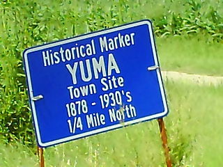
Yuma is a ghost town in Cloud County, Kansas, United States. It is located near the intersections of K-28 and County Road 777. A historical marker remains where the town once stood, which was populated from 1878 until the 1930s.
Buckeye is an unincorporated community in Dickinson County, Kansas, United States.

Sutphen is an unincorporated community in Dickinson County, Kansas, United States.
Upland is an unincorporated community in Dickinson County, Kansas, United States.
Wayne is an unincorporated community in Republic County, Kansas, United States.

The Cloud County Historical Museum is located in Concordia, Kansas. The Museum preserves and exhibits objects and documents of historical items representing early-day Kansas. It is housed in the former 1908 Carnegie library building and an annex.

Carlyle is an unincorporated community in Allen County, Kansas, United States. It was first settled in 1858.

Dunlapsville is an unincorporated community in Liberty Township, Union County, in the U.S. state of Indiana.
Bayard is an unincorporated community in Allen County, Kansas, United States. Although official populations are not compiled for unincorporated places, the population of the surrounding Osage Township was 316 in the 2000 census.
Hale Passage is the name of two different bodies of water in Puget Sound, in the U.S. state of Washington.
Hopewell is an unincorporated community in Pratt County, Kansas, United States. It lies at an elevation of 2047 feet.
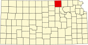
North Central Kansas is a tourism and geographical region of the state of Kansas. It consists of 15 counties, and has a population of over 150,000. The Salina micropolitan area is part of North Central Kansas. The region stretches from the Nebraska border in the north to Russell, Ellsworth, Saline, and Dickinson Counties in the south. Its western border includes Smith, Osborne, and Russell Counties, and its eastern border Dickinson, Clay, Washington, and Marshall Counties.
Macyville is a ghost town in Cloud County, Kansas, United States.
Washington Township is a township in Republic County, Kansas, in the United States. It has an approximate area of 35.92 mi2.
Talmo is an unincorporated community in Republic County, Kansas, United States.
Frost is an unincorporated community in Athens County, in the U.S. state of Ohio.
References
- ↑ U.S. Geological Survey Geographic Names Information System: Hopewell, Washington County, Kansas
- ↑ "Kansas Post Offices, 1828-1961". Kansas Historical Society. Archived from the original on 9 October 2013. Retrieved 27 June 2014.