This article relies largely or entirely on a single source .(April 2021) |
Hopitsewah is a former Pomo settlement in Lake County, California. [1] It was located on the west shore of Clear Lake; its precise location is unknown. [1]
This article relies largely or entirely on a single source .(April 2021) |
Hopitsewah is a former Pomo settlement in Lake County, California. [1] It was located on the west shore of Clear Lake; its precise location is unknown. [1]

The Sierra Nevada is a mountain range in the Western United States, between the Central Valley of California and the Great Basin. The vast majority of the range lies in the state of California, although the Carson Range spur lies primarily in Nevada. The Sierra Nevada is part of the American Cordillera, an almost continuous chain of mountain ranges that forms the western "backbone" of the Americas.

Los Angeles County, officially the County of Los Angeles, is the most populous county in the United States and in the U.S. state of California, with more than ten million inhabitants as of 2018. It is the most populous non–state-level government entity in the United States. Its population is greater than that of 41 individual U.S. states. It has the third-largest metropolitan economy in the world, with a Nominal GDP of more than $700 billion. At 4,083 square miles (10,570 km2) and with 88 incorporated cities and many unincorporated areas, it is larger than the combined areas of Delaware and Rhode Island. The county is home to more than one-quarter of California residents and is one of the most ethnically diverse counties in the United States. Its county seat, Los Angeles, is also California's most populous city and the second most populous city in the United States, with about four million residents.
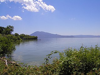
Lake County is a county located in the north central portion of the U.S. state of California. As of the 2010 census, the population was 64,665. The county seat is Lakeport. The county takes its name from Clear Lake, the dominant geographic feature in the county and the largest natural lake wholly within California.

Lake Tahoe is a large freshwater lake in the Sierra Nevada of the United States. Lying at 6,225 ft (1,897 m), it straddles the state line between California and Nevada, west of Carson City. Lake Tahoe is the largest alpine lake in North America, and at 122,160,280 acre⋅ft (150.7 km3) it trails only the five Great Lakes as the largest by volume in the United States. Its depth is 1,645 ft (501 m), making it the second deepest in the United States after Crater Lake in Oregon.

The Great Basin is the largest area of contiguous endorheic watersheds in North America. It spans nearly all of Nevada, much of Oregon and Utah, and portions of California, Idaho, Wyoming, and Baja California, Mexico. It is noted for both its arid climate and the basin and range topography that varies from the North American low point at Badwater Basin in Death Valley to the highest point of the contiguous United States, less than 100 miles (160 km) away at the summit of Mount Whitney. The region spans several physiographic divisions, biomes, ecoregions, and deserts.
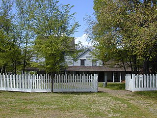
Anderson Marsh State Historic Park is a California State Historic Park and nature reserve preserving a tule marsh, archaeological sites of the Pomo people, and historic ranch structures. It is located in Lake County, California, United States. Anderson Marsh is located at the head of Cache Creek on the southeast corner of Clear Lake, the largest natural lake completely within the borders of California. The park is between the cities of Lower Lake and Clearlake on State Route 53, north of Calistoga in the wine country. The park is open year-round.

The Salton Sea is a shallow, landlocked body of water that has a high concentration of salts in Riverside and Imperial counties, on the San Andreas Fault at the southern end of the U.S. state of California. It lies within the Salton Trough that stretches to the Gulf of California in Mexico. Over millions of years, the Colorado River has flowed into the Imperial Valley and deposited alluvium (soil), creating fertile farmland, building up the terrain, and constantly moving its main river delta. For thousands of years, the river has alternately flowed into and out of the valley, creating a freshwater lake or an increasingly saline lake, and a dry desert basin, respectively, depending on river flows and the balance between inflow and evaporative loss. Hundreds of archaeological sites have been found, indicating possibly long-term Native American villages and temporary camps.

Pyramid Lake is a reservoir formed by Pyramid Dam on Piru Creek in the eastern San Emigdio Mountains, near Castaic, Southern California. It is a part of the West Branch California Aqueduct, which is a part of the California State Water Project. Its water is fed by the system after being pumped up from the San Joaquin Valley and through the Tehachapi Mountains.

Lake Havasu is a large reservoir formed by Parker Dam on the Colorado River, on the border between San Bernardino County, California and La Paz County, Arizona. Lake Havasu City sits on the Arizona (eastern) side of the lake with its Californian counterpart of Havasu Lake directly across the lake. The reservoir has an available capacity of 619,400 acre feet (764,000,000 m3). The concrete arch dam was built by the United States Bureau of Reclamation between 1934 and 1938. The lake's primary purpose is to store water for pumping into two aqueducts. Prior to the dam construction, the area was home to the Mojave Indians. The lake was named after the Mojave word for blue. In the early 19th century, it was frequented by beaver trappers. Spaniards also began to mine the areas along the river.
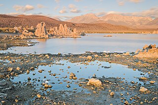
Mono Lake Tufa State Natural Reserve is located near Yosemite National Park within Mono County, in eastern California. It was established in 1981 by the California State Legislature to preserve the natural limestone "tufa tower" formations at Mono Lake.

Castaic Lake is a reservoir formed by Castaic Dam on Castaic Creek, in the Sierra Pelona Mountains of northwestern Los Angeles County, California, United States, near the town of Castaic.

The Klamath Basin is the region in the U.S. states of Oregon and California drained by the Klamath River. It contains most of Klamath County and parts of Lake and Jackson counties in Oregon, and parts of Del Norte, Humboldt, Modoc, Siskiyou, and Trinity counties in California. The 15,751-square-mile (40,790 km2) drainage basin is 35% in Oregon and 65% in California. In Oregon, the watershed typically lies east of the Cascade Range, while California contains most of the river's segment that passes through the mountains. In the Oregon-far northern California segment of the river, the watershed is semi-desert at lower elevations and dry alpine in the upper elevations. In the western part of the basin, in California, however, the climate is more of temperate rainforest, and the Trinity River watershed consists of a more typical alpine climate.

Silverwood Lake is a large reservoir in San Bernardino County, California, United States, located on the West Fork Mojave River, a tributary of the Mojave River in the San Bernardino Mountains. It was created in 1971 as part of the State Water Project by the construction of the Cedar Springs Dam as a forebay on the 444 mi (715 km) long California Aqueduct, and has a capacity of 73,000 acre⋅ft (90,000,000 m3).

Lake Oroville State Recreation Area (LOSRA) is a state park unit of California, United States, surrounding Lake Oroville, a reservoir on the Feather River. It is located in Butte County outside Oroville, California. The 29,447-acre (11,917 ha) park was established in 1967. The recreation area "includes Lake Oroville and the surrounding lands and facilities within the project area as well as the land and waters in and around the Diversion Pool and Thermalito Forebay, downstream of Oroville Dam."

The Boggs Lake Ecological Reserve is a nature reserve in Lake County, California. The land area is about one quarter of a square mile and contains a large vernal pool as well as endangered plants such as the Boggs Lake hedge-hyssop.

Lake Arrowhead is an artificial lake located in the San Bernardino Mountains on Little Bear Creek, a tributary of Deep Creek and the Mojave River. It has a surface area of approximately 780 acres (320 ha) and a capacity of 48,000 acre⋅ft (59,000 dam3). It is surrounded by the unincorporated community of Lake Arrowhead in San Bernardino County, California.

Twin Lakes State Beach is a beach located on Monterey Bay directly south of the Santa Cruz Yacht Harbor Santa Cruz, in coastal Santa Cruz County, northern California.

The California Zephyr is a passenger train operated by Amtrak between Chicago and the San Francisco Bay Area, via Omaha, Denver, Salt Lake City, and Reno. At 2,438 miles (3,924 km), it is Amtrak's longest daily route, and second-longest overall after the Texas Eagle's triweekly continuation from San Antonio to Los Angeles, with travel time between the termini taking approximately 511⁄2 hours. Amtrak claims the route as one of its most scenic, with views of the upper Colorado River valley in the Rocky Mountains, and the Sierra Nevada. The modern train is the second iteration of a train named California Zephyr; the original train was privately operated and ran on a different route through Nevada and California.
| | This Lake County, California–related article is a stub. You can help Wikipedia by expanding it. |
