
Shropshire (; alternatively Salop; abbreviated, in print only, Shrops; demonym Salopiansə-LOH-pee-ən, is a county in England, bordering Wales to the west, Cheshire to the north, Staffordshire to the east, and Worcestershire and Herefordshire to the south. Shropshire Council was created in 2009, a unitary authority taking over from the previous county council and five district councils. The borough of Telford and Wrekin has been a separate unitary authority since 1998 but continues to be included in the ceremonial county.

Ludlow is a market town in Shropshire, England, 28 miles (45 km) south of Shrewsbury and 23 miles (37 km) north of Hereford via the main A49 road, which bypasses the town. With a population of approximately 11,000, Ludlow is the largest town in South Shropshire. The town is significant in the history of the Welsh Marches and neighbouring Wales.

Clun is a small town in south Shropshire, England, and the Shropshire Hills Area of Outstanding Natural Beauty. The 2011 census recorded 680 people living in the town. Research by the Campaign for the Protection of Rural England suggests that Clun is one of the most tranquil locations in England.

Hopton Heath, or Hoptonheath, is a hamlet in south Shropshire, England. The border with Herefordshire is close by. It lies on the border of the civil parishes of Clungunford and Hopton Castle.

Nesscliffe is a village in Shropshire, England, located north of the River Severn. The village comes under the Great Ness parish.

Bedstone is a small village and civil parish in south Shropshire, England, close to the border with Herefordshire.

Craven Arms is a market town and civil parish in Shropshire, England, on the A49 road and the Welsh Marches railway line, which link it north and south to the larger towns of Shrewsbury and Ludlow respectively. The Heart of Wales railway line joins the Welsh Marches line at Craven Arms and the town is served by Craven Arms railway station. The town is enclosed to the north by the Shropshire Hills Area of Outstanding Natural Beauty, and to the south is the fortified manor house of Stokesay Castle.

Minsterley is a village and civil parish in Shropshire, England. In the 2011 census, its population was 1,777. Minsterley lies one mile south-west of Pontesbury and 10 miles south-west of Shrewsbury. East from Minsterley along the A488, is the larger village of Pontesbury and to its south the hill range, the Stiperstones. The Rea Brook flows nearby and the smaller Minsterley Brook flows through the centre of the village.

Hodnet is a village and civil parish in Shropshire, England. The town of Market Drayton lies 5.7 miles (9.2 km) north-east of the village.

Clungunford is a village and civil parish in south Shropshire, England, located near the border with Herefordshire.

Leintwardine is a large village and civil parish in north Herefordshire, England, close to the border with Shropshire.
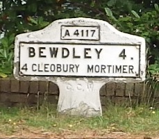
The A4117 is a single-carriageway 'A road' in western England, largely in Shropshire, which passes through part of the Wyre Forest and Clee Hills.
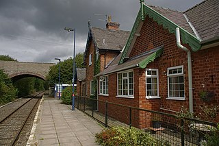
Hopton Heath railway station is a railway station in Hopton Heath, a hamlet in Shropshire, England. It lies on the Heart of Wales Line, 25 1⁄2 miles (41.0 km) south west of Shrewsbury.
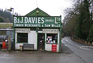
Bucknell is a village and civil parish in south Shropshire, England. The village lies on the River Redlake, within 660 yards (600 m) of the River Teme and close to the border of Wales and Herefordshire. It is about 6 miles (9.7 km) east of Knighton and is set within the Shropshire Hills Area of Outstanding Natural Beauty.

Chirbury is a village in west Shropshire, England. It is situated in the Vale of Montgomery, close to the Wales–England border, which is to its north, west and south. The A490 and B4386 routes cross at Chirbury.

Hopton Castle is situated in the village of the same name which lies approximately halfway between Knighton and Craven Arms, in the English county of Shropshire. Hopton Castle featured in the British TV series Time Team in 2010. A ruin since the early 18th century, it was partially restored between 2006 and 2011, and was officially re-opened to the public as a visitor attraction in December 2011 by the Duke of Gloucester.

Sibdon Carwood is a hamlet and small parish in Shropshire, England. To its east is the small market town of Craven Arms.

Hopton Wafers is a small village and civil parish in south Shropshire, England. The population of the public parish at the 2011 census was 753. It is located on the A4117 road to the west of the market town of Cleobury Mortimer.
Hopton Cangeford, also referred to as Hopton-in-the-Hole, is a small village and civil parish in south Shropshire, England.
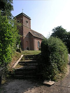
Hopton Castle is a civil parish in Shropshire, England. It contains eleven listed buildings that are recorded in the National Heritage List for England. Of these, one is listed at Grade I, the highest of the three grades, and the others are at Grade II, the lowest grade. The parish contains the village of Hopton Castle and the surrounding countryside. The oldest listed building in the parish consists of the remains of Hopton Castle. Most of the other listed buildings are houses, cottages, farmhouses and farm buildings, all of which are timber framed. In addition a church, two memorials in the churchyard, and a telephone kiosk are listed.


