
Hornton Street is a street in Kensington, London W8. It runs north to south from Sheffield Terrace to Kensington High Street.
Hornton Street is a street in Kensington, London W8. It runs north to south from Sheffield Terrace to Kensington High Street.
Some of the road, at least, was originally called Campden House Road. [1]
A chapel on the corner of Hornton Street and Hornton Place was built in 1794 for Congregationalists on land owned by William Phillimore. [2] By 1858, it became a Baptist chapel. [2] However, it was demolished in 1927. [2]
The street was home to a Nonconformist school until it was torn down in 1868 for the construction of the Metropolitan Railway. [3]
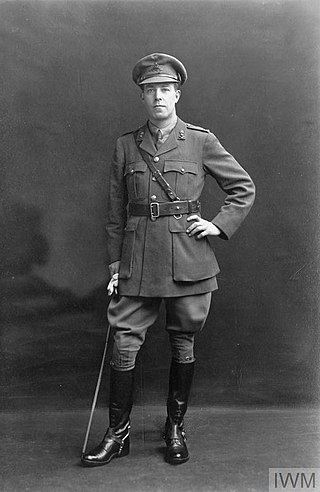
The musician Sir Charles Stanford (1852–1924) lived at No. 56 from 1894 to 1916, and this is commemorated with a blue plaque, erected in 1961. [4]
Many of the houses are listed, including the entire terrace from 12 to 54, built from 1903, and designed by Frank Chesterton; running between Holland Street and Hornton Place, opposite Kensington Town Hall and Kensington Central Library. [5]

Fulham is an ancient and historic settlement within the London Borough of Hammersmith & Fulham in West London, England, 3.6 miles (5.8 km) southwest of Charing Cross. It lies in a loop on the north bank of the River Thames, bordering Hammersmith, Kensington and Chelsea, with which it shares the area known as West Brompton. Over the Thames Fulham faces Wandsworth, Putney, the London Wetland Centre in Barnes in the London Borough of Richmond upon Thames.

Alfred George Stevens, was a British sculptor. His major work is the monument to the Duke of Wellington in St Paul's Cathedral.

Sir John Barker, 1st Baronet was a British entrepreneur of the late 19th and early 20th century. He was the founder of the Barkers department store in Kensington, London, United Kingdom.

Kensington Temple is a Pentecostal Church in the Notting Hill area of London, England. It is the largest church in its denomination, the Elim Pentecostal Church.

All Saints Notting Hill is a Church of England parish church in Talbot Road, Notting Hill, London that is affiliated to the Anglo-Catholic Forward in Faith movement. The church is built in a Victorian Gothic Revival style with striking polychromatic decoration. For heritage purposes the church is a Grade II* listed building.
James Heywood was a British MP, philanthropist and social reformer.
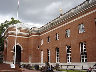
Kensington Central Library is a Grade II* listed building on Hornton Street and Phillimore Walk, Kensington, London. It was built in 1958–60 by the architect E. Vincent Harris on the site of The Abbey, a Gothic house which had been constructed for a Mr Abbot in 1880 and destroyed by bombing in 1944. It was opened by the Queen Elizabeth The Queen Mother on 13 July 1960. The building was designed in a traditional, English, renaissance-style. There were demonstrations against the project by those who advocated for the building to be in a modern style.

Edwardes Square is a garden square in Kensington, London, W8. The square was built between 1811 and 1820. 1–23 and 25–48 Edwardes Square are listed Grade II for their architectural merit.

Earls Terrace is a street in Kensington, London, W8. It has houses on one side only, a terrace of 25 Georgian houses, built in 1800–1810, all of which are Grade II listed. Numbers 1 and 25, at the ends of the terrace, are converted into flats.

Victoria Road is a street in Kensington, London, that in 2015 was considered the most expensive street in the United Kingdom. The street runs north to south from Kensington Road, Kensington High Street in close proximity to Kensington Palace and the Royal Albert Hall. Victoria Road actually runs from Kensington Road and not from Kensington High Street as cited previously. There are 64 properties on the street including the Embassy of Vietnam.

The Zetland Arms is a pub in South Kensington, London, on the corner of Old Brompton Road and Bute Street.

The Milestone Hotel is a five-star hotel at 1 Kensington Court, Kensington, London, United Kingdom. It overlooks Kensington Gardens.

Kensington United Reformed Church is a Grade II listed church in Allen Street, Kensington, London, England.

The church of Our Lady of Mount Carmel and St Simon Stock is a Roman Catholic church at 41 Kensington Church Street, Kensington, London W8, served by Discalced Carmelites.
Frank Sidney Chesterton FRICS was an English architect.

The Kensington Vestry Hall is a former municipal building on Kensington High Street in Kensington, London, England. The structure, which was built for Kensington Vestry and now accommodates Bank Melli Iran is a Grade II listed building.

Campden Hill Road is a street in Kensington, London W8. It runs north to south from Notting Hill Gate to Kensington High Street.

Lillie Road is a major street in the north of Fulham, in the London Borough of Hammersmith and Fulham. Named for the Peninsular War veteran, John Scott Lillie, it is a mixed residential and commercial thoroughfare, and is the westerly continuation of the Old Brompton Road, the A3218 road, running from Lillie Bridge to the A219 Fulham Palace Road. Its main junctions are with North End Road and with Munster Road at Fulham Cross.
North End was, until the last quarter of the 19th-century, a scattered hamlet among the fields and market gardens, between Counter's Creek and Walham Green in the Parish of Fulham in the County of Middlesex.
![]() Media related to Hornton Street at Wikimedia Commons
Media related to Hornton Street at Wikimedia Commons