
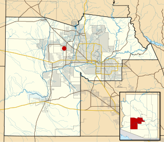
Maricopa County is in the south-central part of the U.S. state of Arizona. As of the 2020 census, the county's population was 4,420,568, making it the state's most populous county, and the fourth-most populous in the United States. It contains about 62% of Arizona's population, making Arizona one of the most centralized states in the nation. The county seat is Phoenix, the state capital and fifth-most populous city in the United States.

Mesa is a city in Maricopa County, in the U.S. state of Arizona. It is the most populous city in the East Valley section of the Phoenix Metropolitan Area. It is bordered by Tempe on the west, the Salt River Pima-Maricopa Indian Community on the north, Chandler and Gilbert on the south along with Queen Creek, and Apache Junction on the east.
Tempe is a city in Maricopa County, Arizona, United States, with the Census Bureau reporting a 2020 population of 180,587. The city is named after the Vale of Tempe in Greece. Tempe is located in the East Valley section of metropolitan Phoenix; it is bordered by Phoenix and Guadalupe on the west, Scottsdale and the Salt River Pima–Maricopa Indian Community on the north, Chandler on the south, and Mesa on the east. Tempe is also the location of the main campus of Arizona State University.

The Gila River is a 649-mile (1,044 km)-long tributary of the Colorado River flowing through New Mexico and Arizona in the United States. The river drains an arid watershed of nearly 60,000 square miles (160,000 km2) that lies mainly within the U.S., but also extends into northern Sonora, Mexico.

The Salt River is a river in Gila and Maricopa counties in Arizona, United States, that is the largest tributary of the Gila River. The river is about 200 miles (320 km) long. Its drainage basin is about 13,700 square miles (35,000 km2) large. The longest of the Salt River's many tributaries is the 195-mile (314 km) Verde River. The Salt's headwaters tributaries, the Black River and East Fork, increase the river's total length to about 300 miles (480 km). The name Salt River comes from the fact that the river flows over large salt deposits shortly after the merging of the White and Black Rivers.
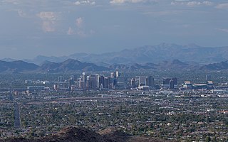
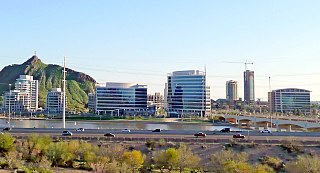
The Phoenix Metropolitan Area – also the Valley of the Sun, the Salt River Valley, or Metro Phoenix – is the largest metropolitan area in the Southwestern United States, centered on the city of Phoenix, that includes much of the central part of Arizona. The United States Office of Management and Budget designates the area as the Phoenix-Mesa-Scottsdale Metropolitan Statistical Area (MSA), defining it as Maricopa and Pinal counties. As of the 2020 census, Metro Phoenix had 4,845,832 residents, making it the 11th largest metropolitan area in the nation by population. It anchors the Arizona Sun Corridor megaregion along with the second most populous metropolitan area in the state, the Tucson metropolitan area. The gross domestic product of the Phoenix Metropolitan Area was $255 billion in 2018, 16th largest amongst metro areas in the United States.

Tortilla Flat is a small unincorporated community in far eastern Maricopa County, Arizona, United States. It is located in the central part of the state, northeast of Apache Junction. It is the last surviving stagecoach stop along the Apache Trail. According to the Gross Management Department of Arizona's main U.S. Post Office in Phoenix, Tortilla Flat is presumed to be Arizona's smallest official "community" having a U.S. Post Office and voting precinct. The town has a population of 6. Tortilla Flat can be reached by vehicles on the Apache Trail, via Apache Junction.
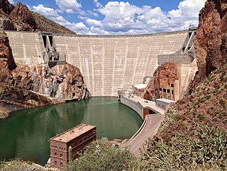
Theodore Roosevelt Dam is a dam on the Salt River located northeast of Phoenix, Arizona. The dam is 357 feet (109 m) high and forms Theodore Roosevelt Lake as it impounds the Salt River. Originally built between 1905 and 1911, the dam was renovated and expanded in 1989–1996. The dam is named after President Theodore Roosevelt. Serving mainly for irrigation, water supply, and flood control, the dam also has a hydroelectric generating capacity of 36 megawatts.

The Stewart Mountain Dam is a concrete thin arch dam located 41 miles northeast of Phoenix, Arizona. The dam is 1,260 feet (380 m) long, 207 feet (63 m) high, and was built between 1928 and 1930. The dam includes a 13,000 kilowatt (kW) hydroelectric generating unit that is operated by SRP, an Arizona public utility. It is primarily operated during the summer months. The dam forms Saguaro Lake as it slows the passage of the Salt River in Maricopa County, Arizona. It was named after a ranch that used to be located nearby known as the Old Stewart Ranch.

This is a list of the National Register of Historic Places listings in Maricopa County, Arizona, excluding those in Phoenix, for which see this separate list.
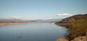
Theodore Roosevelt Lake is a large reservoir formed by Theodore Roosevelt Dam on the Salt River in Arizona as part of the Salt River Project (SRP). Located roughly 80 miles (130 km) northeast of Phoenix in the Salt River Valley, Theodore Roosevelt is the largest lake or reservoir located entirely within the state of Arizona. The reservoir and the masonry dam that created it, Roosevelt Dam, were both named after U.S. President Theodore Roosevelt who dedicated the dam himself in March 1911. Roosevelt Lake is a popular recreation destination within the Tonto National Forest; the facilities located at this lake are managed by that authority.
Waddell is an unincorporated community in Maricopa County, Arizona, United States, northwest of the city of Phoenix. Waddell is named after Donald Ware Waddell, a native of Ohio, who was a partner in the New York City investment firm of Brandon, Gordon and Waddell. It was this firm that organized the private financing for construction of the dam for the water reclamation project that creates Lake Pleasant. The intended Waddell town site was laid out by Donald W. Waddell in 1935, on property he owned on the northeast corner of Waddell Road and Cotton Lane. Waddell moved to the area to oversee the firm's interests in the project. He served on the board of the Maricopa Water District and invested in land through his interests in the Arizona Citrus Land Company and the Waddell Ranch Company.

The Arizona State Fair is an annual state fair, held at Arizona State Fairgrounds.

The Mormon Flat Dam is a dam on the Salt River located Northeast of Phoenix, Arizona.

The Bartlett Dam is a concrete multiple-arch buttress dam on the Verde River, located 50 km northeast of Phoenix, Arizona. The dam creates Bartlett Lake and its primary purpose is irrigation water supply. It was the first dam constructed on the Verde River and the first of its type constructed by the U.S. Bureau of Reclamation. It was built between 1936 and 1939. It was named after Bill Bartlett, a government surveyor. It was listed on the National Register of Historic Places in 2017.
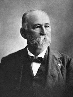
William Augustus Hancock was an American pioneer, attorney, and politician. Arriving in Arizona Territory during the American Civil War, he settled in the Salt River Valley. There he performed the survey work required to create the town of Phoenix as well as holding a variety of governmental offices at the city and county levels.

The following is a timeline of the history of the area which today comprises the U.S. state of Arizona. Situated in the desert southwest, for millennia the area was home to a series of Pre-Columbian peoples. By 1 AD, the dominant groups in the area were the Hohokam, the Mogollon, and the Ancestral Puebloans. The Hohokam dominated the center of the area which is now Arizona, the Mogollon the southeast, and the Puebloans the north and northeast. As these cultures disappeared between 1000 and 1400 AD, other Indian groups settled in Arizona. These tribes included the Navajo, Apache, Southern Paiute, Hopi, Yavapai, Akimel O'odham, and the Tohono O'odham.

Salt River is a populated place situated in Maricopa County, Arizona, United States. It has an estimated elevation of 1,220 feet (370 m) above sea level. It is located on the Salt River Pima–Maricopa Indian Community.
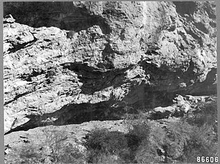
Skeleton Cave is a cave in Maricopa County, Arizona, United States. The cave is within the Salt River Canyon Wilderness and is located on the northern wall of the Salt River Canyon near the Horse Mesa Dam. It was the site of the 1872 massacre of the Yavapai people in the Battle of Salt River Canyon.


