
Frank Hague was an American Democratic Party politician who served as the Mayor of Jersey City from 1917 to 1947, Democratic National Committeeman from New Jersey from 1922 until 1949, and Vice-Chairman of the Democratic National Committee from 1924 until 1949. During his 30 years as mayor, Hague established reforms and innovations that upgraded the city's infrastructure and services, including the construction of parks, schools, and public housing. He also worked to secure funding for public works projects and attracted new businesses to the city, which helped to boost its economy. Simultaneously Mayor Hague had a dark reputation for corruption, extortion and bossism and has been called "the grandaddy of Jersey bosses". By the time he left office in 1947, he enjoyed palatial homes, European vacations, and a private suite at the Plaza Hotel. His wealth has been estimated to have been over $10 million at the time of his death, although his City salary never exceeded $8,500 per year and he had no other legitimate source of income.

The Main Line is a commuter rail line owned and operated by New Jersey Transit running from Suffern, New York to Hoboken, New Jersey, in the United States. It runs daily commuter service and was once the north–south main line of the Erie Railroad. It is colored yellow on NJ Transit system maps, and its symbol is a water wheel.

Bergen Arches is an abandoned railroad right of way through Bergen Hill in Jersey City, New Jersey.
The Waterfront Connection allows NJ Transit trains to switch from the former Pennsylvania Railroad main line to the former Delaware, Lackawanna and Western Railroad main line, now NJ Transit Rail Operations. The connection opened on September 9, 1991, at a cost of $16 million.

Marion Junction is a railroad junction in western Jersey City, New Jersey. Currently, it connects CSX's River Line to Conrail's Passaic and Harsimus Line. The two lines merge towards the west, allowing through trains from upstate New York to continue towards the rest of the country. The track actually making the connection is known as the Marion Running Track.

Paulus Hook is a community on the Hudson River waterfront in Jersey City, New Jersey. It is located one mile across the river from Manhattan. The name Hook comes from the Dutch word "hoeck", which translates to "point of land." This "point of land" has been described as an elevated area, the location of which today is bounded by Montgomery, Hudson, Dudley, and Van Vorst Streets.
Exchange Place is a district of Downtown Jersey City, New Jersey that is sometimes referred to as Wall Street West due to the concentration of financial companies that have offices there. The namesake is a square, about 200 feet long, at the foot of Montgomery Street at the waterfront of the Hudson River. This square was created by landfilling the shore at Paulus Hook, and has been a major transportation hub since the colonial era.

Newport is a 600-acre (2.4 km2) master-planned, mixed-use community in Downtown Jersey City, in the U.S. state of New Jersey, consisting of retail, residential, office, and entertainment facilities. The neighborhood is situated on the Hudson Waterfront on what had been the yards of Erie Railroad's Pavonia Terminal, located opposite Lower Manhattan and the neighborhood of Tribeca in New York City. Redevelopment of the neighborhood began in 1986 as a $10 billion project led by real-estate tycoon Samuel J. LeFrak and his firm The LeFrak Organization.

The Central Railroad of New Jersey Terminal, also known as Communipaw Terminal and Jersey City Terminal, was the Central Railroad of New Jersey's waterfront passenger terminal in Jersey City, New Jersey. The terminal was built in 1889, replacing an earlier one that had been in use since 1864. It operated until April 30, 1967.

Pavonia Terminal was the Erie Railroad terminal on the Hudson River located in the Harsimus section of Jersey City, New Jersey. The station opened in 1861 and closed in 1958 when the Erie Railroad moved its passenger services to nearby Hoboken Terminal. The New York, Susquehanna and Western Railway also ran commuter trains from the terminal and various street cars, ferries and the underground Hudson and Manhattan Railroad serviced the station. The station was abandoned in 1958 and demolished in 1961. The site was eventually redeveloped into the Newport district in the late 20th century.
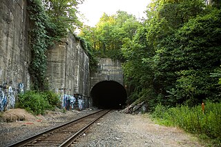
The Long Dock Tunnel is a freight rail tunnel in Jersey City, New Jersey that is part of the North Jersey Shared Assets Area and used by CSX Transportation on the National Docks Secondary. The single track tunnel runs through Bergen Hill, a section of the lower New Jersey Palisades in Hudson County.

Little Falls station is a NJ Transit station located at Union Avenue in Little Falls, New Jersey. The station, on the Montclair-Boonton Line is the first to receive limited revenue service due to the end of electrification at the site of the former Great Notch station.

Bergen Hill refers to the lower Hudson Palisades in New Jersey, where they emerge on Bergen Neck, which in turn is the peninsula between the Hackensack and Hudson Rivers, and their bays. In Hudson County, it reaches a height of 260 feet.

The Hudson River Waterfront Walkway, also known as the Hudson River Walkway, is a promenade along the Hudson Waterfront in New Jersey. The ongoing and incomplete project located on Kill van Kull and the western shore of Upper New York Bay and the Hudson River was implemented as part of a New Jersey state-mandated master plan to connect the municipalities from the Bayonne Bridge to the George Washington Bridge with an urban linear park and provide contiguous unhindered access to the water's edge.

Pavonia was the first European settlement on the west bank of the North River that was part of the seventeenth-century province of New Netherland in what would become the present Hudson County, New Jersey.

Droyer's Point is a section of Jersey City, New Jersey, at Newark Bay that was the site of the Jersey City Airport and later of Roosevelt Stadium, both of which were demolished. It has become a residential and commercial district.
Harsimus is a neighborhood within Downtown Jersey City, Hudson County, in the U.S. state of New Jersey. The neighborhood stretches from the Harsimus Stem Embankment on the north to Christopher Columbus Drive on the south between Coles Street and Grove Street or more broadly, to Marin Boulevard. It borders the neighborhoods of Hamilton Park to the north, Van Vorst Park to the south, the Village to the west, and the Powerhouse Arts District to the east. Newark Avenue has traditionally been its main street. The name is from the Lenape, used by the Hackensack Indians who inhabited the region and could be translated as Crow's Marsh. From many years, the neighborhood was part of the "Horseshoe", a political delineation created by its position between the converging rail lines and political gerrymandering.

Van Vorst Park is a neighborhood in the Historic Downtown of Jersey City, Hudson County, New Jersey, centered on a park sharing the same name. The neighborhood is located west of Paulus Hook and Marin Boulevard, north of Grand Street, east of the Turnpike Extension, and south of The Village and Christopher Columbus Drive. Much of it is included in the Van Vorst Park Historical District.

Ridgefield Park station, also known as West Shore Station, was a railroad station in Ridgefield Park, New Jersey, at the foot of Mount Vernon Street served by the New York, Susquehanna and Western Railroad (NYSW) and the West Shore Railroad, a division of New York Central (NYCRR). The New York, Ontario and Western Railway (NYO&W) had running rights along the West Shore and sometimes stopped at Ridgefield Park. First opened in 1872 it was one of three passenger stations in the village, the others being the Little Ferry station to the south and Westview station to the north. Service on the West Shore Railroad began in 1883. The station house, built at a cost $100,000 opened in 1927. Southbound service crossed Overpeck Creek and continued to terminals on the Hudson River waterfront where there was connecting ferry service across the Hudson River to Manhattan. Northbound near Bogota the parallel NYSW and West Shore lines diverge and continue into northern New Jersey, Pennsylvania, and upstate New York. Passenger service ended in 1966.

The Chambers Street Ferry Terminal was the Erie Railroad's main ferry slip on Manhattan and the point of departure and embarkation for passengers in New York City. The terminal was one of several operated by ferry companies and railroads that lined the western shore of Manhattan during the 19th and 20th centuries. The Pavonia Ferry operated for over 100 years from the terminal, which was demolished about three years after the Erie Railroad stopped its ferry service to Chambers Street in December, 1958.

