
Glastonbury is a town and civil parish in Somerset, England, situated at a dry point on the low-lying Somerset Levels, 23 miles (37 km) south of Bristol. The town, which is in the Mendip district, had a population of 8,932 in the 2011 census. Glastonbury is less than 1 mile (2 km) across the River Brue from Street, which is now larger than Glastonbury.

Sherborne Abbey, otherwise the Abbey Church of St. Mary the Virgin, is a Church of England church in Sherborne in the English county of Dorset. It has been a Saxon cathedral (705–1075), a Benedictine abbey church (998–1539), and since 1539, a parish church.

Sir George Gilbert Scott, known as Sir Gilbert Scott, was a prolific English Gothic Revival architect, chiefly associated with the design, building and renovation of churches and cathedrals, although he started his career as a leading designer of workhouses. Over 800 buildings were designed or altered by him.

Glastonbury Abbey was a monastery in Glastonbury, Somerset, England. Its ruins, a grade I listed building and scheduled ancient monument, are open as a visitor attraction.

Milton Abbas is a village and civil parish in Dorset, England, lying around 5 miles southwest of Blandford Forum. In the 2011 Census the civil parish had a population of 755.

Froxfield is a village and civil parish in the English county of Wiltshire. The parish is on the Wiltshire-West Berkshire border, and the village lies on the A4 national route about 2.5 miles (4 km) west of Hungerford and 7 miles (11 km) east of Marlborough.
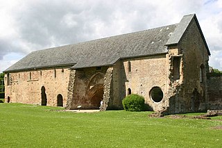
Muchelney Abbey is an English Heritage property in the village of Muchelney in the Somerset Levels, England. The site consists of ruined walls showing the layout of the abbey buildings constructed from the 7th to 16th centuries, and the remaining intact Abbot's House. It is next to the parish church in which some of the fabric of the abbey has been reused.
Cleeve Abbey is a medieval monastery located near the village of Washford, in Somerset, England. It is a Grade I listed building and has been scheduled as an ancient monument.

St Margaret's Almshouses are part of a 12th-century leper colony in Taunton, Somerset, England.

Ditcheat is a village and civil parish 4.5 miles (7 km) south of Shepton Mallet, and 2.5 miles (4 km) north-west of Castle Cary, in the Mendip district of Somerset, England. Besides the village, the parish has four hamlets: Wraxall, Lower Wraxall, Alhampton and Sutton.

Meare is a village and civil parish 3 miles (4.8 km) north west of Glastonbury on the Somerset Levels, in the Mendip district of Somerset, England. The parish includes the village of Westhay.

East Brent is a village and civil parish, on the eastern edge of a hill that dominates the surrounding level countryside—Brent Knoll—close to the M5 motorway, 5 miles (8 km) west of Axbridge, in the Sedgemoor district of the county of Somerset, in the south-west of England. The parish includes the hamlets of Rooksbridge, where the A38 road crosses the Mark Yeo and Edingworth.

The Grade I listed buildings in Somerset, England, demonstrate the history and diversity of its architecture. The ceremonial county of Somerset consists of a non-metropolitan county, administered by Somerset County Council, which is divided into five districts, and two unitary authorities. The districts of Somerset are West Somerset, South Somerset, Taunton Deane, Mendip and Sedgemoor. The two administratively independent unitary authorities, which were established on 1 April 1996 following the breakup of the county of Avon, are North Somerset and Bath and North East Somerset. These unitary authorities include areas that were once part of Somerset before the creation of Avon in 1974.
Mendip is a local government district in the English county of Somerset. The Mendip district covers a largely rural area of 285 square miles (738 km2) ranging from the Mendip Hills through on to the Somerset Levels. It has a population of approximately 11,000. The administrative centre of the district is Shepton Mallet.

Gray's Almshouses is a terrace of almshouses in Taunton, Somerset, England, founded in 1635 by the wealthy cloth-merchant Robert Gray, whose monument survives in the Church of St Mary Magdalene. The building is one of the oldest surviving in Taunton and is one of the earliest brick buildings in the county. The Almshouses were designed to provide accommodation for six men and ten women and for a reader who was to act as chaplain and schoolmaster. It is a Grade I listed building as designated by English Heritage. Following renovation in the late twentieth century it now comprises sheltered accommodation of nine flats for the elderly.

The Abbot's Fish House in Meare, Somerset, England, was built in the 14th century and has been designated as a Grade I listed building and Scheduled Ancient Monument. It is the only surviving monastic fishery building in England.

Mendip is a local government district in the English county of Somerset. The Mendip district covers a largely rural area of 285 square miles (738 km2) ranging from the Mendip Hills through on to the Somerset Levels. It had a population of approximately 110,000 in 2014. The administrative centre of the district is Shepton Mallet.

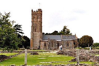
The Anglican Church of St Benedict at Glastonbury within the English county of Somerset was built as a Norman chapel in the 11th century with substantial additions in the 15th and 19th centuries. It is a Grade I listed building.
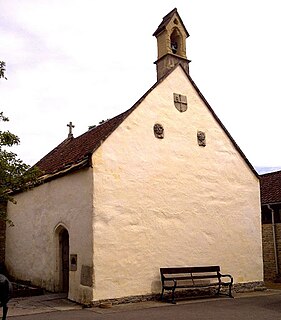
St. Patrick's Chapel in Glastonbury, Somerset, England, is housed within the grounds of Glastonbury Abbey, and was completed in 1517. It is a site of pilgrimage and dedicated to Saint Patrick due to it being close to a possible site of his burial. It sits within the scheduled Ancient Monument area and is a Grade II listed building. The Stained Glass and wall painting are the results of a renovation. Saint Patrick is depicted twice within the chapel, once within the stained glass behind the altar which shows him in his traditional green robe standing above a snake and another on the wall which depicts him with a wolfhound. Weekly services are still held within the Chapel and it 'has been witness to 500 years of Christian worship.'

