
Carlisle is a cathedral city in the ceremonial county of Cumbria in England. It is the administrative centre of Cumberland Council which covers an area similar to the historic county of Cumberland.

Cumbria is a ceremonial county in North West England. It borders the Scottish council areas of Dumfries and Galloway and Scottish Borders to the north, Northumberland and County Durham to the east, North Yorkshire to the south-east, Lancashire to the south, and the Irish Sea to the west. Its largest settlement is the city of Carlisle.

Cumberland is a historic county in North West England, covering part of the Lake District as well as the northern Pennines and the coast of Solway Firth. Cumberland had an administrative function from the 12th century until 1974, when it was subsumed into Cumbria, a larger administrative area which also covered Westmorland and parts of Yorkshire and Lancashire. In April 2023, Cumberland was revived as an administrative entity when Cumbria County Council was abolished and replaced by two unitary authorities, one of which is named Cumberland and includes most of the historic county, with the exception of Penrith and the surrounding area.

The City of Carlisle was a local government district of Cumbria, England, with the status of a city. It was named after its largest settlement, Carlisle, but covered a far larger area which included the towns of Brampton and Longtown, as well as outlying villages including Dalston, Scotby and Wetheral. In 2011 the district had a population of 107,524, and an area of 1,039.97 square kilometres (402 sq mi).

Cumbria Constabulary is the territorial police force in England covering the unitary authority areas of Cumberland and Westmorland and Furness in the ceremonial county of Cumbria. As of September 2017, the force had 1,108 police officers, 535 police staff, 93 police community support officers, and 86 special constables.

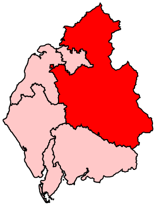
Carlisle is a constituency in Cumbria represented in the House of Commons of the UK Parliament since 2010 by John Stevenson of the Conservative Party.
Penrith and The Border is a constituency in Cumbria represented in the House of Commons of the UK Parliament since 2019 by Neil Hudson, a Conservative.

Hesket is a large civil parish in the Eden District of Cumbria, England, on the main A6 between Carlisle and Penrith. At the 2001 census it had a population of 2,363, increasing to 2,588 at the 2011 census, and estimated at 2,774 in 2019. The parish was formed in 1894 with the passing of the Local Government Act 1894 and was enlarged to incorporate the parish of Plumpton Wall following a County Review Order in 1934. Hesket is part of the historic royal hunting ground of Inglewood Forest. Settlement in the parish dates back to the Roman occupation.
Stanwix is a district of Carlisle, Cumbria in North West England. The ward population had a population taken at the 2011 census of 5,934. It is located on the north side of River Eden, across from Carlisle city centre. Although long counted as a suburb it did not officially become part of the city until 1912 when part of the civil parish of Stanwix became part of the parish, city and municipal borough of Carlisle. Further areas were added to the city, which was by then a county borough, in 1934 and 1951. The remaining part of the parish was eventually renamed Stanwix Rural in 1966.

Stanwix Rural is a civil parish in the City of Carlisle district of Cumbria, England, immediately to the north east of Carlisle itself – parts of the Carlisle urban area are in the parish boundaries.

Crosby-on-Eden is the combined name for two small villages, High Crosby and Low Crosby, within the civil parish of Stanwix Rural near Carlisle, in the Cumberland district, in the ceremonial county of Cumbria, England. It was formerly a parish in its own right under the name Crosby upon Eden. In 1931 the parish had a population of 238. On 1 April 1934 the parish was abolished and merged with Stanwix Rural, part also went to Wetheral.
Cargo is a small village near the River Eden on the Solway Plain. Cargo is about 3+1⁄2 miles (5.6 km) northwest of Carlisle in Cumbria in the North West of England. The name Cargo reflects a combination of two languages; from the Celtic word carreg meaning "rock" and from the Old Norse word haugr meaning "hill". Circa 1870, it had a population of 262 as recorded in the Imperial Gazetteer of England and Wales.
Rickerby is a village in the civil parish of Stanwix Rural, in the City of Carlisle district, in the county of Cumbria, England. It is situated near Carlisle, next to the River Eden. In 1870-72 the township had a population of 97. The property belonged to Richard de Tilliol of Scaleby Castle, whose descendant Adam de Rickerby lived in the village in about 1230. Rickerby Park is nearby.

Calthwaite is a small village in rural Cumbria, England, situated between the small market town of Penrith and the larger city of Carlisle. It is within of the civil parish of Hesket and the district of Eden, and has a population of around 100 people. In 1870-72 the township had a population of 269.

Linstock is a village in the civil parish of Stanwix Rural, in the Carlisle District, in the county of Cumbria, England. It is a few miles away from the city of Carlisle and near the River Eden. Circa 1870, it had a population of 205 as recorded in the Imperial Gazetteer of England and Wales.

Brunstock is a hamlet in the civil parish of Stanwix Rural, in the Carlisle district, in the county of Cumbria, England. Circa 1870, the township had a population of 84 as recorded in the Imperial Gazetteer of England and Wales.

Tarraby is a hamlet in the Carlisle district, in the county of Cumbria, England. Circa 1870, it had a population of 106 as recorded in the Imperial Gazetteer of England and Wales.
Stainton is a hamlet in the Kingmoor parish of Cumberland, Cumbria, England. It is near the city of Carlisle. Circa 1870, it had a population of 63 as recorded in the Imperial Gazetteer of England and Wales.
Etterby is a former village in Cumbria, England. It is now a northwestern suburb of Carlisle, on the northern side of the River Eden. The Redfern Inn (1939–1940) was designed by the architect Harry Redfern in the New Model Inn style. In 1870-72 the township had a population of 319.
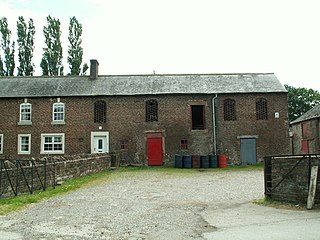
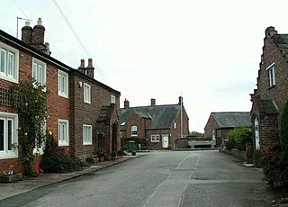
Stanwix Rural is a civil parish in the Carlisle district of Cumbria, England. It contains 63 listed buildings that are recorded in the National Heritage List for England. Of these, three are listed at Grade II*, the middle of the three grades, and the others are at Grade II, the lowest grade. The parish is to the northeast of the city of Carlisle, and contains the villages of Houghton, Low Crosby, High Crosby, Brunstock, Linstock, Tarraby, and Rickerby, and the surrounding countryside. The oldest two listed buildings originated as tower houses, and have since been extended and altered. Most of the listed buildings are country houses and smaller houses, some with associated structures, farmhouses and farm buildings. The other listed buildings include churches, milestones, a public house, schools, a war memorial, and an isolated tower.


