Dillingham Airfield is a public and military use airport located two nautical miles (4 km) west of the central business district of Mokulēʻia, in Honolulu County on the North Shore of Oʻahu in the U.S. state of Hawaii. It is operated by the Hawaii Department of Transportation under a 25-year lease from the United States Army. The airport is primarily used for gliding and sky diving operations, and also houses Civil Air Patrol (CAP) glider aircraft. Military operations consist largely of night operations for night vision device training and orientation flights for the United States Air Force Auxiliary (CAP). This airport is included in the Federal Aviation Administration (FAA) National Plan of Integrated Airport Systems for 2017–2021, in which it is categorized as a basic general aviation facility.

Modesto City–County Airport is two miles (3 km) southeast of Modesto in Stanislaus County, California, United States.

Presque Isle International Airport, formally Northern Maine Regional Airport at Presque Isle, is a mile northwest of Presque Isle, in Aroostook County, Maine, United States. It serves the residents of Presque Isle and a vast area of northern Maine and northwestern New Brunswick. Airline flights to Newark Liberty International Airport are subsidized by the federal government's Essential Air Service program at a cost of $3,892,174.

Sierra Vista Municipal Airport, a joint-use civil-military airport which shares facilities with Libby Army Airfield, is located on Fort Huachuca in Sierra Vista, a city and U.S. Army installation in Cochise County, Arizona, United States. The airport has three runways and one helipad. It is mostly used for military aviation for the surrounding military base.

Niagara Falls International Airport is located 4 mi (6.4 km) east of downtown Niagara Falls, in the Town of Niagara in Niagara County, New York, United States. Owned and operated by the Niagara Frontier Transportation Authority, the airport is a joint civil-military airfield and shares its runways with the Niagara Falls Air Reserve Station. A new terminal building opened in 2009. It is notable for serving vastly more Canadian passengers from over the nearby border than Americans.

Salinas Municipal Airport, commonly referred to as Salinas Airport is an airport in Monterey County, California, United States, three miles (4.8 km) southeast of Downtown Salinas. It is included in the 2017–21 National Plan of Integrated Airport Systems as a regional general aviation airport. It had 1,800 enplanements in 2014.
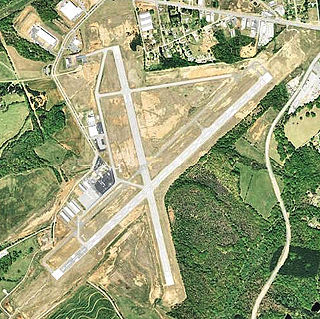
Anderson Regional Airport is a public airport 3 nautical miles southwest of Anderson, in Anderson County, South Carolina, United States. It is one of the busiest airports in upstate South Carolina. It receives over 14,000 visitors each year and generates over $13 million annually.

Annette Island Airport is located on Annette Island in the Prince of Wales – Hyder Census Area of the U.S. state of Alaska. It is located 5 nautical miles (9 km) south of Metlakatla, Alaska. The airport was established as the Annette Island Army Airfield during World War II and initially served as a military airbase.

Southern Wisconsin Regional Airport is a public airport located southwest of Janesville and north of Beloit in Rock County, Wisconsin, United States. Formerly known as Rock County Airport, it is owned and operated by the Rock County government. The airport has no scheduled commercial passenger service.
Auburn-Lewiston Airport is a public airport in Androscoggin County, Maine, United States. It opened in 1935. It is five miles southwest of the cities of Auburn and Lewiston, which jointly own and operate the airport.

Grayling Army Airfield is a public/military use airport located one nautical mile (1.85 km) northwest of the central business district of Grayling, in Crawford County, Michigan, United States. It is owned by United States Army. The airfield is located 7 miles (11 km) northeast of the main cantonment area of Camp Grayling. It is included in the Federal Aviation Administration (FAA) National Plan of Integrated Airport Systems for 2017–2021, in which it is categorized as a general aviation facility.
Sanford Seacoast Regional Airport is a public airport located four miles (6 km) southeast of the central business district of Sanford, a town in York County, Maine, United States. The airport operated as Naval Auxiliary Air Facility Sanford supporting operations of Naval Air Station Brunswick from 15 April 1943 until 1 February 1946. This airport is now publicly owned by the City of Sanford.
Flagler Executive Airport (ICAO: KFIN, FAA LID: FIN) is a county-owned public-use airport located three miles (5 km) east of the central business district of Bunnell, a city in Flagler County, Florida, United States. The airport's former FAA location identifiers were X47 and XFL. The airfield was originally constructed by the United States Navy during World War II as Naval Outlying Field Bunnell (NOLF Bunnell), an auxiliary airfield for flight training operations originating from nearby Naval Air Station Jacksonville, NAS Daytona Beach and NAS DeLand. Following the end of the war, the airfield was transferred from the Navy to Flagler County for use as a general aviation airport.
During World War II, the United States Army Air Forces (USAAF) established numerous airfields in Maine for training pilots and aircrews of USAAF fighters and bombers.

Greenwood County Airport is a county-owned, public-use airport located three nautical miles (6 km) north of the central business district of Greenwood, a city in Greenwood County, South Carolina, United States. It is included in the National Plan of Integrated Airport Systems for 2011–2015, which categorized it as a general aviation facility. The airport does not have scheduled commercial airline service.
Esler Field, also known as Esler Regional Airport, is a military and public use airfield in Rapides Parish, Louisiana, United States, near the City of Pineville. It is located 10 nautical miles northeast of the central business district of Alexandria, Louisiana, The airfield is owned by the Louisiana Army National Guard and is the home of Army Aviation Support Facility #2 (AASF#2).

Grenada Municipal Airport is a public use airport in Grenada County, Mississippi, United States. It is owned by the City of Grenada and located three nautical miles (6 km) north of the central business district. This airport is included in the National Plan of Integrated Airport Systems for 2011–2015, which categorized it as a general aviation facility. There is no scheduled commercial airline service.

Grand Strand Airport is a county-owned, public-use airport located one nautical mile (1.85 km) northwest of the central business district of North Myrtle Beach, in Horry County, South Carolina, United States. The name Grand Strand refers to a nearby 60-mile stretch of beach; its code CRE refers to nearby Crescent Beach.

Fort Sumner Municipal Airport is a village owned, public use airport located two nautical miles (4 km) northeast of the central business district of Fort Sumner, a village in De Baca County, New Mexico, United States. It is included in the National Plan of Integrated Airport Systems for 2011–2015, which categorized it as a general aviation airport.

Deblois Flight Strip is a public-use airport located two nautical miles southeast of the central business district of Deblois, a town in Washington County, Maine, United States. It is currently owned by the Maine Department of Transportation, and managed by Randy Gray, Superintendent of Operations for the Eastern Region.


