Firth is a word in the English and Scots languages used to denote various coastal waters in the United Kingdom, predominantly within Scotland. In the Northern Isles, it more often refers to a smaller inlet. It is linguistically cognate to Scandinavian fjord and fjard, with the original meaning of "sailable waterway". The word has a more constrained sense in English. Bodies of water named "firths" tend to be more common on the Scottish east coast, or in the southwest of the country, although the Firth of Clyde is an exception to this. The Highland coast contains numerous estuaries, straits, and inlets of a similar kind, but not called "firth" ; instead, these are often called sea lochs. Before about 1850, the spelling "Frith" was more common.

The Mainland, also known as Hrossey and Pomona, is the main island of Orkney, Scotland. Both of Orkney's burghs, Kirkwall and Stromness, lie on the island, which is also the heart of Orkney's ferry and air connections.
Yell is one of the North Isles of Shetland, Scotland. In the 2011 census it had a usually resident population of 966. It is the second largest island in Shetland after the Mainland with an area of 82 square miles (212 km2), and is the third most populous in the archipelago, after the Mainland and Whalsay.

Fetlar is one of the North Isles of Shetland, Scotland, with a usually resident population of 61 at the time of the 2011 census. Its main settlement is Houbie on the south coast, home to the Fetlar Interpretive Centre. Other settlements include Aith, Funzie, Herra and Tresta. Fetlar is the fourth-largest island of Shetland and has an area of just over 4,000 ha.
Papa Stour is one of the Shetland Islands in Scotland, with a population of under fifteen people, some of whom immigrated after an appeal for residents in the 1970s. Located to the west of mainland Shetland and with an area of 828 hectares, Papa Stour is the ninth largest island in Shetland. Erosion of the soft volcanic rocks by the sea has created an extraordinary variety of caves, stacks, arches, blowholes, and cliffs. The island and its surrounding seas harbour diverse populations of wildlife. The west side of the island is a Site of Special Scientific Interest and the seas around the island are a Special Area of Conservation.

West Burra is one of the Scalloway Islands, a subgroup of the Shetland Islands in Scotland. It is connected by bridge to East Burra. With an area of 743 hectares, it is the eleventh-largest of the Shetland Islands.
The Out Skerries are an archipelago of islets, some inhabited, in Shetland, Scotland, and are the easternmost part of Shetland. Locally, they are usually called Da Skerries or just Skerries.
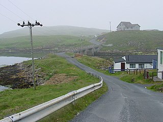
Vaila is an island in Shetland, Scotland, lying south of the Westland peninsula of the Shetland Mainland. It has an area of 327 hectares, and is 95 metres (312 ft) at its highest point.
Trondra is one of the Scalloway Islands, a subgroup of the Shetland Islands in Scotland. It shelters the harbour of Scalloway and has an area of 275 hectares (1.06 sq mi).
Bruray is one of the three Out Skerries islands of Shetland, and contains Scotland's most easterly settlement.
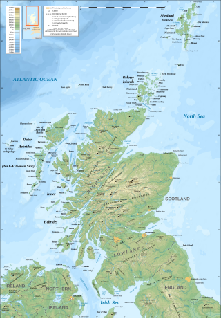
The geography of Scotland is varied, from rural lowlands to unspoilt uplands, and from large cities to sparsely inhabited islands. Located in Northern Europe, Scotland comprises the northern part of the island of Great Britain as well as 790 surrounding islands encompassing the major archipelagos of the Shetland Islands, Orkney Islands and the Inner and Outer Hebrides. The only land border is with England, which runs for 96 miles in a northeasterly direction from the Solway Firth in the west to the North Sea on the east coast. Separated by the North Channel, the island of Ireland lies 13 nautical miles from Mull of Kintyre on the Scottish mainland. Norway is located 190 nmi (350 km) northeast of Scotland across the North Sea. The Atlantic Ocean, which fringes the coastline of western and northern Scotland and its islands, influences the temperate, maritime climate of the country.

The Islands of the Forth are a group of small islands located in the Firth of Forth and in the estuary of the River Forth on the east coast of Scotland. Most of the group lie in the open waters of the firth, between the Lothians and Fife, with the majority to the east of the city of Edinburgh. Two islands lie further west in the river estuary.

Yell Sound is the Sound running between Yell and Mainland, Shetland, Scotland. It is the boundary between the Mainland and the North Isles and it contains many small islands. Sullom Voe, on the shores of which is a substantial oil terminal, is an arm of Yell Sound.
Events from the year 1899 in Scotland.

St Magnus Bay is a large coastal feature in the north-west of Mainland Shetland, Scotland. Roughly circular in shape with a diameter of about 19 kilometres (12 mi), it is open to the North Atlantic Ocean to the west. The indented coastline to the north, south and east between Esha Ness in the north and the Ness of Melby in the south contains numerous bays, firths and voes and there are several islands around the perimeter. The waters of the bay are up to 165 metres (541 ft) deep and may have been the site of a substantial meteor impact.

Kettla Ness, Kettlaness or just Kettla is a tied island and headland in Shetland. It is connected by the tombolo Minn beach, to the south end of West Burra, part of the Scalloway Islands. The headland itself is conspicuous and circa 160 feet high. The island is accessible to walkers via Minn beach and is now uninhabitated. It is principally used for Sheep farming and pasture.


