
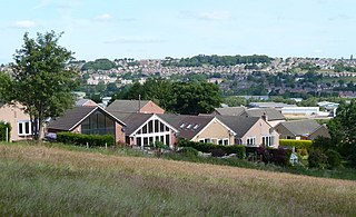
A suburb is an area within a metropolitan area, which may include commercial and mixed-use, that is primarily a residential area. A suburb can exist either as part of a larger city/urban area or as a separate political entity. The name describes an area which is not as densely populated as an inner city, yet more densely populated than a rural area in the countryside. In many metropolitan areas, suburbs exist as separate residential communities within commuting distance of a city Suburbs can have their own political or legal jurisdiction, especially in the United States, but this is not always the case, especially in the United Kingdom, where most suburbs are located within the administrative boundaries of cities. In most English-speaking countries, suburban areas are defined in contrast to central or inner city areas, but in Australian English and South African English, suburb has become largely synonymous with what is called a "neighborhood" in other countries, and the term encompasses inner city areas.

A metropolitan area or metro is a region that consists of a densely populated urban agglomeration and its surrounding territories sharing industries, commercial areas, transport network, infrastructures and housing. A metro area usually comprises multiple principal cities, jurisdictions and municipalities: neighborhoods, townships, boroughs, cities, towns, exurbs, suburbs, counties, districts, as well as even states and nations like the eurodistricts. As social, economic and political institutions have changed, metropolitan areas have become key economic and political regions.

Commuting is periodically recurring travel between one's place of residence and place of work or study, where the traveler, referred to as a commuter, leaves the boundary of their home community. By extension, it can sometimes be any regular or often repeated travel between locations, even when not work-related. The modes of travel, time taken and distance traveled in commuting varies widely across the globe. Most people in least-developed countries continue to walk to work, as the ancestors of all people did until the nineteenth century. The cheapest method of commuting after walking is usually by bicycle, so this is common in low-income countries, but is also increasingly practised by people in wealthier countries for environmental and health reasons. In middle-income countries, motorcycle commuting is very common. The next technology adopted as countries develop is more dependent on location: in more populous, older cities, especially in Eurasia mass transit predominates, while in smaller, younger cities, and large parts of North America and Australasia, commuting by personal automobile is more common. A small number of very wealthy people, and those working in remote locations around the world, also commute by air travel, often for a week or more at a time rather than the more typical daily commute. Transportation links that enable commuting also impact the physical layout of cities and regions, allowing a distinction to arise between mostly-residential suburbs and the more economically focused urban core of a city, but the specifics of how that distinction is realized remain drastically different between societies, with Eurasian "suburbs" often being more densely populated than North American "urban cores".
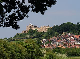
Bolsover is a market town and the administrative centre of the Bolsover District, Derbyshire, England. It is 145 miles (233 km) from London, 18 miles (29 km) from Sheffield, 26 miles (42 km) from Nottingham and 27 miles (43 km) from Derby. It is the main town in the Bolsover district.
North East Derbyshire is a local government district in Derbyshire, England. It borders the districts of Chesterfield, Bolsover, Amber Valley and Derbyshire Dales in Derbyshire, and Sheffield and Rotherham in South Yorkshire. The population of the district as taken at the 2011 Census was 99,023. The district council is a non-constituent partner member of the Sheffield City Region Combined Authority. The district is a non-constituent member of the Sheffield City Region and shares a membership along with neighbouring Derbyshire Dales, Borough of Chesterfield, Bolsover District and Bassetlaw District in Nottinghamshire. The district is also part of The Derby, Derbyshire, Nottingham and Nottinghamshire Local Enterprise Partnership.
Urban economics is broadly the economic study of urban areas; as such, it involves using the tools of economics to analyze urban issues such as crime, education, public transit, housing, and local government finance. More specifically, it is a branch of microeconomics that studies urban spatial structure and the location of households and firms.
Urban sprawl is defined as "the spreading of urban developments on undeveloped land near a city." Urban sprawl has been described as the unrestricted growth in many urban areas of housing, commercial development, and roads over large expanses of land, with little concern for urban planning. In addition to describing a special form of urbanization, the term also relates to the social and environmental consequences associated with this development. Medieval suburbs suffered from loss of protection of city walls, before the advent of industrial warfare. Modern disadvantages and costs include increased travel time, transport costs, pollution, and destruction of the countryside. The cost of building urban infrastructure for new developments is hardly ever recouped through property taxes, amounting to a subsidy for the developers and new residents at the expense of existing property taxpayers.

The Seattle metropolitan area is an urban conglomeration in the U.S. state of Washington that comprises Seattle, its surrounding satellites and suburbs. It contains the three most populous counties in the state—King, Snohomish, and Pierce—and is considered part of the greater Puget Sound region. The United States Census Bureau defines the metropolitan area as the Seattle–Tacoma–Bellevue, WA metropolitan statistical area. With an estimated population of 4,102,400 as of 2022, it is the 15th largest metropolitan statistical area (MSA) in the United States and is home to over half of Washington's population.

A company town is a place where practically all stores and housing are owned by the one company that is also the main employer. Company towns are often planned with a suite of amenities such as stores, houses of worship, schools, markets and recreation facilities. They are usually bigger than a model village.

Shirebrook is a town in the Bolsover district in Derbyshire, England. Close to the boundaries with the districts of Mansfield and Bassetlaw of Nottinghamshire, it had a population of 13,300 in 2001, reducing to 9,760 at the 2011 Census. It is on the B6407, and close to the A632 road, between Mansfield and Bolsover.
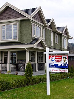
Real estate economics is the application of economic techniques to real estate markets. It tries to describe, explain, and predict patterns of prices, supply, and demand. The closely related field of housing economics is narrower in scope, concentrating on residential real estate markets, while the research on real estate trends focuses on the business and structural changes affecting the industry. Both draw on partial equilibrium analysis, urban economics, spatial economics, basic and extensive research, surveys, and finance.

Suburbanization is a population shift from central urban areas into suburbs, resulting in the formation of (sub)urban sprawl. As a consequence of the movement of households and businesses out of the city centers, low-density, peripheral urban areas grow. Sub-urbanization is inversely related to urbanization, which denotes a population shift from rural areas into urban centers.

South Normanton is a village and civil parish in the Bolsover District of Derbyshire, England. The population at the 2011 Census was 9,445. An ex-mining village, it is two miles east of Alfreton. The historic industries of the village were agriculture, stocking, spinning and mining. Normanton means 'the farm of the north men' or 'Northwegans'.
Elections to Preston Borough Council were held on 6 May 1999. One third of the council was up for election and the Labour Party kept overall control of the council after a Liberal Democrat councillor defected to them on the night of the counting of the votes.

A commuter town is a populated area that is primarily residential rather than commercial or industrial. Routine travel from home to work and back is called commuting, which is where the term comes from. A commuter town may be called by many other terms: "bedroom community", "bedroom town", "bedroom suburb" (US), "dormitory town", or "dormitory suburb" (Britain/Commonwealth/Ireland). In Japan, a commuter town may be referred to by the wasei-eigo coinage "bed town". The term "exurb" was used from the 1950s, but since 2006, is generally used for areas beyond suburbs and specifically less densely built than the suburbs to which the exurbs' residents commute.
Bolsover Tunnel is a disused and infilled twin-track railway tunnel between Carr Vale and Scarcliffe in Derbyshire, England.

Union Square/Market Street station is an underground Muni Metro light rail station located adjacent to Union Square in San Francisco, California. It opened on November 19, 2022, as part of the Central Subway project. Initial service is a shuttle between Chinatown and 4th and Brannan; T Third Street service will move to the Central Subway on January 7, 2023.

Schotia Place is a heritage-listed former market and now community centre at 201 Bolsover Street, Rockhampton City, Rockhampton, Rockhampton Region, Queensland, Australia. It was designed by Eaton & Bates and built in 1898. It is also known as former Rockhampton City Markets and Rockhampton Senior Citizens Centre. It was added to the Queensland Heritage Register on 21 October 1992.

The Borough of Chesterfield is a non-metropolitan district with borough status in Derbyshire, England. It is named after its main settlement of Chesterfield.
Old Bolsover is a civil parish in the Bolsover District of Derbyshire, England. The parish contains 55 listed buildings that are recorded in the National Heritage List for England. Of these, one is listed at Grade I, the highest of the three grades, six are at Grade II*, the middle grade, and the others are at Grade II, the lowest grade. The parish contains the market town of Bolsover and the surrounding area, including the village of Shuttlewood. The older part of the town has been a market town since the medieval period, and the area of New Bolsover is a model village built between 1888 and 1893 for colliery workers. A row of six semi-detached houses was built for the managers, over 200 houses were built for the other workers in terraces forming three sides of a quadrangle, and community buildings were also erected. All these buildings are listed. The most prominent building in the parish is Bolsover Castle, a country house in the style of a castle, which is listed, together with associated structures, including five conduit houses. Most of the other listed buildings are houses, cottages, shops and associated structures, farmhouses and farm buildings. The rest include a church, a chapel, a former windmill and a nearby chimney, a war memorial, a school and a telephone kiosk.