
This is a list of properties and districts in Indiana that are listed on the National Register of Historic Places. There are over 1,900 in total. Of these, 39 are National Historic Landmarks. Each of Indiana's 92 counties has at least two listings.

This is a list of the National Register of Historic Places listings in Marion County, Indiana.

The Portland Mills Covered Bridge is the second oldest covered bridge in Parke County, Indiana, being built the same year as the Crooks Covered Bridge. It is a single span Burr Arch Truss covered bridge that was built by Henry Wolf in 1856.

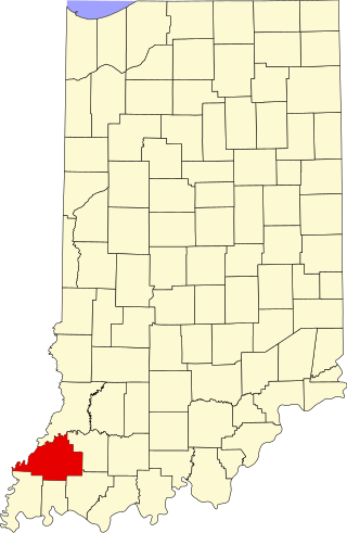
Point Township is one of ten townships in Posey County, Indiana. As of the 2000 census, its population was 497. The lowest, the southernmost, and the westernmost points in Indiana are all located along the township's boundaries.

Polk Township is one of eleven townships in Monroe County, Indiana. As of the 2010 census, its population was 360 and it contained 195 housing units. It is one of the least densely-populated townships in the state; this is largely because most of the land is occupied by Lake Monroe, the Hoosier National Forest, and seasonal homes and attractions.

The Abbott Farm Historic District is a National Historic Landmark archaeological site in New Jersey. It is the largest known Middle Woodland village of its type on the East Coast of the United States. Significant evidence suggests that the Delaware River floodplain was occupied by Paleoindian people for a long period. It was inhabited between 500 BC and 500 AD. It has been a source of controversy and debate around early development.

This is a list of the National Register of Historic Places listings in Lake County, Indiana.

This is a list of the National Register of Historic Places listings in Dearborn County, Indiana.

This is a list of the National Register of Historic Places listings in Tippecanoe County, Indiana.

This is a list of the National Register of Historic Places listings in Boone County, Indiana.

This is a list of the National Register of Historic Places listings in Clark County, Indiana.
This is a list of the National Register of Historic Places listings in Gibson County, Indiana.

This is a list of the National Register of Historic Places listings in Hancock County, Indiana.

This is a list of the National Register of Historic Places listings in Henry County, Indiana.

This is a list of the National Register of Historic Places listings in Posey County, Indiana.
This is a list of the National Register of Historic Places listings in Harrison County, Indiana.

This is a list of the National Register of Historic Places listings in Center Township, Marion County, Indiana.

The Ashworth Archaeological Site is a significant archaeological site in the extreme southwestern corner of the U.S. state of Indiana. Located near the confluence of the Ohio and Wabash Rivers, it lies near several similar archaeological sites. It was first examined by archaeologists in the middle of the twentieth century and found to be the site of a relatively recent Native American village, and it has been designated a historic site because of its archaeological value.

The Sommerheim Park Archaeological District includes a group of six archaeological sites west of Erie, Pennsylvania in the United States. The sites are in Sommerheim Park, one of the few undeveloped areas of the Lake Erie shoreline, in Millcreek Township. This district has been listed on the National Register of Historic Places. This is one of the leading archaeological sites in the Erie area and along the southern shoreline of Lake Erie, due to the amount of artifacts and the lack of disturbance on the site.

The Rockhouse Cliffs Rockshelters are a pair of rockshelters in the far southern region of the U.S. state of Indiana. Located amid broken terrain in the Hoosier National Forest, the shelters may have been inhabited for more than ten thousand years by peoples ranging from the Early Archaic period until the twentieth century. As a result of their extensive occupation and their remote location, they are important and well-preserved archaeological sites and have been named a historic site.


