Atherton is a town in the Metropolitan Borough of Wigan in Greater Manchester, England and historically part of Lancashire. The town, including Hindsford, Howe Bridge and Hag Fold, is 5 miles (8.0 km) south of Bolton, 7 miles (11.3 km) east of Wigan, and 10 miles (16.1 km) northwest of Manchester. From the 17th century, for about 300 years, Atherton was known as Chowbent, which was frequently shortened to Bent, the town's old nickname. During the Industrial Revolution, the town was a key part of the Manchester Coalfield.
Agecroft Colliery was a coal mine on the Manchester Coalfield that opened in 1844 in the Agecroft district of Pendlebury, Lancashire, England. It exploited the coal seams of the Middle Coal Measures of the Lancashire Coalfield. The colliery had two spells of use; the first between 1844 and 1932, when the most accessible coal seams were exploited, and a second lease of life after extensive development in the late 1950s to access the deepest seams.

Wet Earth Colliery was a coal mine located on the Manchester Coalfield, in Clifton, Greater Manchester. The colliery site is now the location of Clifton Country Park. The colliery has a unique place in British coal mining history; apart from being one of the earliest pits in the country, it is the place where engineer James Brindley made water run uphill.

The Lancashire Coalfield in North West England was an important British coalfield. Its coal seams were formed from the vegetation of tropical swampy forests in the Carboniferous period over 300 million years ago.
The Astley and Tyldesley Collieries Company formed in 1900 owned coal mines on the Lancashire Coalfield south of the railway in Astley and Tyldesley, then in the historic county of Lancashire, England. The company became part of Manchester Collieries in 1929 and some of its collieries were nationalised in 1947.

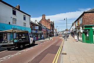
Howe Bridge is a suburb of Atherton, Greater Manchester, England. Historically within Lancashire, it is situated to the south west of Atherton town centre on the B5215, the old turnpike road from Bolton to Leigh. The settlement was built as a model pit village by the owners of Atherton Collieries.
Manchester Collieries was a coal mining company with headquarters in Walkden formed from a group of independent companies operating on the Manchester Coalfield in 1929. The Mining Industry Act of 1926 attempted to stem the post-war decline in coal mining and encourage independent companies to merge in order to modernise and better survive the economic conditions of the day. Robert Burrows of the Atherton company Fletcher Burrows proposed a merger of several independent companies operating to the west of Manchester. The merger was agreed and took place in March 1929.
Fletcher, Burrows and Company was a coal mining company that owned collieries and cotton mills in Atherton, Greater Manchester, England. Gibfield, Howe Bridge and Chanters collieries exploited the coal mines (seams) of the middle coal measures in the Manchester Coalfield. The Fletchers built company housing at Hindsford and a model village at Howe Bridge which included pithead baths and a social club for its workers. The company became part of Manchester Collieries in 1929. The collieries were nationalised in 1947 becoming part of the National Coal Board.

Astley Green Colliery was a coal mine in Astley, Greater Manchester, then in the historic county of Lancashire, England. It was the last colliery to be sunk in Astley. Sinking commenced in 1908 by the Pilkington Colliery Company, a subsidiary of the Clifton and Kersley Coal Company, at the southern edge of the Manchester Coalfield, working the Middle Coal Measures where they dipped under the Permian age rocks under Chat Moss. The colliery was north of the Bridgewater Canal. In 1929 it became part of Manchester Collieries, and in 1947 was nationalised and integrated into the National Coal Board. It closed in 1970, and is now Astley Green Colliery Museum.

Gibfield Colliery was a coal mine owned by Fletcher, Burrows and Company in Atherton, then in the historic county of Lancashire, England.
Chanters Colliery was a coal mine which was part of the Fletcher, Burrows and Company's collieries at Hindsford in Atherton, Greater Manchester, then in the historic county of Lancashire, England.
Nook Colliery was a coal mine operating on the Manchester Coalfield after 1866 in Tyldesley, Greater Manchester, then in the historic county of Lancashire, England.
Yew Tree Colliery was a coal mine operating on the Manchester Coalfield after 1845 in Tyldesley, Greater Manchester, then in the historic county of Lancashire, England.
Cleworth Hall Colliery was a coal mine operating on the Manchester Coalfield after 1874 in Tyldesley, Greater Manchester, then in the historic county of Lancashire, England.
Peelwood Colliery was a coal mine operating on the Manchester Coalfield after 1883 in Shakerley, Tyldesley, Greater Manchester, then in the historic county of Lancashire, England.
Nelson Pit was a coal mine operating on the Manchester Coalfield from the 1830s or 1840s in Shakerley, Tyldesley, Greater Manchester, then in the historic county of Lancashire, England.
Mosley Common Colliery was a coal mine originally owned by the Bridgewater Trustees operating on the Manchester Coalfield after 1866 in Mosley Common, Greater Manchester, then in the historic county of Lancashire, England. The colliery eventually had five shafts and became the largest colliery on the Lancashire Coalfield with access to around 270 million tons of coal under the Permian rocks to the south.

Bradford Colliery was a coal mine in Bradford, Manchester, England. Although part of the Manchester Coalfield, the seams of the Bradford Coalfield correspond more closely to those of the Oldham Coalfield. The Bradford Coalfield is crossed by a number of fault lines, principally the Bradford Fault, which was reactivated by mining activity in the mid-1960s.

The Burnley Coalfield is the most northerly portion of the Lancashire Coalfield. Surrounding Burnley, Nelson, Blackburn and Accrington, it is separated from the larger southern part by an area of Millstone Grit that forms the Rossendale anticline. Occupying a syncline, it stretches from Blackburn past Colne to the Yorkshire border where its eastern flank is the Pennine anticline.

Bank Hall Colliery was a coal mine on the Burnley Coalfield in Burnley, Lancashire near the Leeds and Liverpool Canal. Sunk in the late 1860s, it was the town's largest and deepest pit and had a life of more than 100 years.
