Related Research Articles

A ghost town, deserted city, or abandoned city is an abandoned village, town, or city, usually one that contains substantial visible remaining buildings and infrastructure such as roads. A town often becomes a ghost town because the economic activity that supported it has failed or ended for any reason. The town may also have declined because of natural or human-caused disasters such as floods, prolonged droughts, extreme heat or extreme cold, government actions, uncontrolled lawlessness, war, pollution, or nuclear disasters. The term can sometimes refer to cities, towns, and neighborhoods that, though still populated, are significantly less so than in past years; for example, those affected by high levels of unemployment and dereliction.
Duncan may refer to:
Neville Langrell "Bill" Barlee was a Canadian politician who was first elected to the Legislative Assembly of British Columbia as a New Democrat in 1988. He served as Minister of Agriculture, Fisheries and Food from 1991 until 1993 and then as Minister of Small Business, Tourism and Culture from 1993 until 1996.

Clinton Creek is a ghost town in Yukon. It was a small company-owned asbestos mining town in western Yukon near the confluence of the Yukon and Fortymile rivers. It operated by the Cassiar Asbestos Corporation, which also operated the asbestos mine in Cassiar, British Columbia, from 1967 to 1978, when it was closed and all the buildings were auctioned off.
Emory Creek Provincial Park is a provincial park in British Columbia, Canada, located on the west side of the Fraser River just south of the town of Yale. It commemorates the location of a large boomtown, variously known as Emory, Emory Bar or Emory City, that first rose during the Fraser Canyon Gold Rush but became a major construction town during the building of the Canadian Pacific Railway in the 1880s.
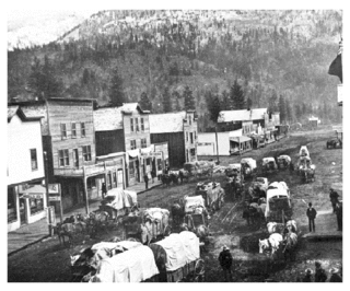
Emory Creek in 1858 was a tent and shack camp, established by miners in search of gold. When it became evident that the gold was not available in the amounts estimated, the miners started moving north on the Fraser River. A few Chinese remained in the area. The area came into the hands of a man named Walker, who felt Emory Creek would become the head of riverboat navigation on the Fraser. Eventually, he sold the land to the Oppenheimer Brothers in early 1879. In the fall of 1879, Emory was chosen by the C.P.R. as the western terminus. In a short time it became Emory Creek. The town consisted of thirteen streets with its own newspaper, various shops, a brewery, nine saloons and a sawmill. When Yale was made the terminus, Emory was all but abandoned by 1885, with the completion of the railway. Today, it is an easily accessible treed campground with paved roads and flush outhouses.
Goat Range Provincial Park is a provincial park in British Columbia, Canada.

School District 28 Quesnel is a school district in central British Columbia. Most schools are located in Quesnel with one outlying school in Wells, a small community near the historic gold mining town of Barkerville and another school in the community of Nazko which is 100 km west of Quesnel.
The Similkameen Gold Rush, also known as the Blackfoot Gold Rush, was a minor gold rush in the Similkameen Country of the Southern Interior of British Columbia, Canada, in 1860. The Similkameen Rush was one of a flurry of small rushes peripheral to the Fraser Canyon Gold Rush, which had drawn tens of thousands of prospectors to the new colony in 1858-1859, among the others being Rock Creek Gold Rush and Big Bend.
The Cassiar Country, also referred to simply as the Cassiar, is a historical geographic region of the Canadian province of British Columbia. The Cassiar is located in the northwest portion of British Columbia, just to the northeast of the Stikine Country, while to the south is the Omineca Country. The area is noted for the Cassiar gold rush of the 1870s, when Laketon became its unofficial capital. The ghost town of Cassiar is also located in the Cassiar region.

Del Bonita is a hamlet in southern Alberta, Canada within Cardston County. It is located approximately 49 km (30 mi) south of Magrath at the junction of Highway 62 and Highway 501. Due to its location near the Canada–United States border, it serves as a port of entry into the U.S. state of Montana at the nearby Del Bonita Border Crossing which is located 3 km (1.9 mi) to the south. Del Bonita is a name derived from Spanish meaning "of the pretty".
Cascade City or Cascade was a Canadian Pacific Railway construction era boom town in the Boundary Country of the West Kootenay region of British Columbia, Canada. Because of its location near the Canada–United States border, it was also called the "Gateway to the Boundary Country".

This is a list of lists of ghost towns in Canada. A ghost town is a town that once had a considerable population, that has since dwindled in numbers causing some or all its business to close, either due to the rerouting of a highway, train tracks being pulled, or exhaustion of some natural resource.

Bralorne is a historic Canadian gold mining community in the Bridge River District of British Columbia, some 130 km on dirt roads west of the town of Lillooet.

Phoenix is a ghost town in the Boundary Country of British Columbia, Canada, 11 km east of Greenwood. Once called the “highest city in Canada” by its citizens it was a booming copper mining community from the late 1890s until 1919. In its heyday it was home to 1,000 citizens and had an opera house, twenty hotels, a brewery and its own city hall. Phoenix’s magistrate, Judge Willie Williams, who served there from 1897 until 1913, became famous for his booming declaration, “I am the highest judge, in the highest court, in the highest city in Canada.” In 1911, Phoenix’s hockey team won the provincial championship and asked for the right to compete for the Stanley Cup, but it was too late to qualify. The Granby Consolidated Mining, Smelting and Power Company operated the Phoenix Mine, a copper mine that produced 13,678,901 tons of ore before operations ceased on June 14, 1919.
Kitsault is an unincorporated settlement and a private town on the North Coast of British Columbia, Canada, at the head of Alice Arm, Observatory Inlet and at the mouth of the Kitsault River. The locality of Alice Arm and the Nisga'a community of Gits'oohl are in the immediate vicinity. "Kitsault" is an adaptation of Gits'oohl, which means "a ways in behind".
Victoria may refer to:

Arrowhead is a former steamboat port and town at the head of Upper Arrow Lake in British Columbia, Canada. Apart from the cemetery, the initial site has been submerged beneath the waters of the lake, which is now part of the reservoir formed by Hugh Keenleyside Dam at Castlegar. However, the name still identifies the locality, and sometimes the local region.

Fairview is a ghost town in British Columbia on the west side of the Okanagan River between Cawston and Oliver. It is the original townsite for what is now the town of Oliver, famous for the Fairview Hotel that burned down in 1902.
Hill's Bar is a long-abandoned ghost town located in the Fraser Canyon region of British Columbia, Canada. The site of the former boomtown is situated near the right bank of the Fraser River, between Yale and the mouth of Emory Creek. The eponymous bar was the first active placer mining site at the onset of the Fraser Canyon Gold Rush, and was the scene of the Boatmakers of San Francisco claim, which included Ned McGowan of McGowan's War, and involved a dispute with Kowpelst, chief of the Spuzzum people.
References
- ↑ Basque Garnet (1982), British Columbia Ghost Town Atlas. Sunfire Publications Limited.
| | This Canadian ghost town-related article is a stub. You can help Wikipedia by expanding it. |