Huey P. Long Bridge (Baton Rouge)

Last updated

Huey P. Long Bridge
Huey P. Long Bridge in Baton Rouge, Louisiana (USA), on 14 December 2021.jpg
Huey P. Long Bridge from the southwest
Coordinates 30°30′25″N91°11′51″W / 30.50694°N 91.19750°W / 30.50694; -91.19750
Carries4 lanes of US 190.svg US 190
1 Canadian Pacific Kansas City rail line
Crosses Mississippi River
Locale Baton Rouge, Louisiana
Official nameHuey P. Long - O.K. Allen Bridge
Other name(s)Old Bridge
Maintained by Louisiana Department of Transportation and Development [1]
ID number 611700071000001
Characteristics
Design Cantilever truss bridge
Total length5,879 feet (1,792 m)
Clearance below 113 feet (34 m)
History
Construction cost$8.4 million [2]
OpenedAugust 1940
Statistics
Daily traffic 17,300
Location
Huey P. Long Bridge (Baton Rouge)

The Huey P. Long - O.K. Allen Bridge (locally known as the Old Bridge) is a truss cantilever bridge over the Mississippi River carrying US 190 (Airline Highway) and one rail line between East Baton Rouge Parish, Louisiana and West Baton Rouge Parish, Louisiana.

Contents

Although the bridge is named after former Louisiana governors Huey P. Long and Oscar K. Allen, it is known locally in the Baton Rouge Area as "the old bridge". [3]

It was the only bridge across the Mississippi in Baton Rouge from its opening until April 1968, when the Horace Wilkinson Bridge ("the new bridge") carrying Interstate 10 opened. Until 2011, when the John James Audubon Bridge opened between St. Francisville and New Roads, it was the last bridge crossing the Mississippi before the Natchez-Vidalia Bridge, almost 100 miles to the north.

Design

The entrance to the Kaiser Aluminum plant under the bridge in 1972 ENTRANCE TO THE KAISER ALUMINUM PLANT BENEATH THE MISSISSIPPI RIVER BRIDGE. BECAUSE OF CORROSIVE FUMES FROM NEARBY... - NARA - 546085.jpg
The entrance to the Kaiser Aluminum plant under the bridge in 1972

The bridge is similar in design to the Huey P. Long Bridge in Jefferson Parish, Louisiana (until the downstream bridge was widened to six lanes in 2013). Its lanes are narrow and during cold weather, it has a tendency to ice over.

Due to the low height of the bridge, Baton Rouge is the furthest inland port on the Mississippi River that can accommodate ocean-going tankers and cargo carriers. The ships transfer their cargo (grain, oil, cars, containers) at Baton Rouge onto rails and pipelines (to travel east–west) or barges (to travel north). In addition, the river depth decreases significantly just to the north, near Port Hudson. [4]

State of repair

The bridge in 2006, viewed from the northwest. Here, the bridge still bears its 1960s orange paint. Huey P Long Bridge Baton Rouge northwest 1.jpg
The bridge in 2006, viewed from the northwest. Here, the bridge still bears its 1960s orange paint.

The bridge itself is currently in a poor state of repair; the girder foundations on both railroad approach spans are beginning to show hairline cracks, but engineers have assured the city that the bridge is not in any imminent danger. [3]

The bridge has been repainted several times since its construction, including in the mid-1960s when the bridge was repainted orange; this was done to match the color of dust being emitted by the Kaiser Aluminum plant on the southeast bank of the river, which continually coated the bridge with aluminum oxide (bauxite) dust. [5] [6] It was widened in 1989, and again repainted between 2014 and 2016 to its original color of light gray. [7] [8]

Planned Interstate 410

The bridge was once planned as part of an Interstate 410.

Accidents

Only one person is reported to have driven off the edge of the bridge. In 1945, a cargo truck driver headed eastbound careened off the sides. The driver fell through the windshield and was crushed on a dock as his truck landed on top of him. [3] The scars from the accident can still be seen on the dock to one's right approaching the east end of the eastbound span.

The bridge is featured in a scene in the 1982 Richard Pryor film, The Toy.

See also

Related Research Articles

<span class="mw-page-title-main">Baton Rouge, Louisiana</span> Capital city of Louisiana, United States

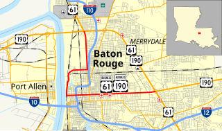
Baton Rouge is the capital city of the U.S. state of Louisiana. Located on the eastern bank of the Mississippi River, it had a population of 227,470 as of 2020; it is the seat of Louisiana's most populous parish (county-equivalent), East Baton Rouge Parish, and the center of Louisiana's second-largest metropolitan area, Greater Baton Rouge.

<span class="mw-page-title-main">Interstate 12</span> Interstate in Louisiana

Interstate 12 (I-12) is an Interstate Highway located entirely within the US state of Louisiana. It spans a total of 85.59 miles (137.74 km) in an east–west direction from I-10 in Baton Rouge to an interchange with both I-10 and I-59 in Slidell. Along the way, it passes through the city of Hammond, where it intersects I-55 and US Route 51 (US 51). It also serves the cities of Ponchatoula and Denham Springs, as well as the St. Tammany Parish cities of Covington and Mandeville. Skirting the northern shore of Lake Pontchartrain, I-12 serves as both a northern bypass of the New Orleans metropolitan area and an alternate route for I-10, which serves the city of New Orleans itself.

<span class="mw-page-title-main">West Baton Rouge Parish, Louisiana</span> Parish in Louisiana, United States

West Baton Rouge Parish is one of the sixty-four parishes in the U.S. state of Louisiana. Established in 1807, its parish seat is Port Allen. With a 2020 census population of 27,199 residents, West Baton Rouge Parish is part of the Baton Rouge metropolitan statistical area.

<span class="mw-page-title-main">Port Allen, Louisiana</span> City in Louisiana, United States

Port Allen is a city in, and the parish seat of, West Baton Rouge Parish, Louisiana, United States. Located on the west bank of the Mississippi River, it is bordered by Interstate 10 and US Highway 190. The population was 4,939 in 2020. It is part of the Baton Rouge metropolitan statistical area.

<span class="mw-page-title-main">U.S. Route 190</span> Highway in the United States

U.S. Route 190 (US 190) is an east–west United States Highway in Louisiana and Texas. Segments of US 190 will be upgraded to Interstate 14 (I-14); the first 24.8-mile (39.9 km) segment was opened on January 26, 2017.

<span class="mw-page-title-main">Oscar K. Allen</span> American politician (1882–1936)

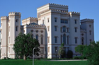
Oscar Kelly Allen Sr., also known as O. K. Allen, was the 42nd Governor of Louisiana from 1932 to 1936.

<span class="mw-page-title-main">Interstate 110 (Louisiana)</span> Highway in Louisiana

Interstate 110 (I-110) is an auxiliary Interstate Highway in the U.S. state of Louisiana. It runs 9.06 miles (14.58 km) in a north–south direction as a spur of I-10 in the city of Baton Rouge.

<span class="mw-page-title-main">Horace Wilkinson Bridge</span> Bridge in Baton Rouge, Louisiana

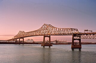
The Horace Wilkinson Bridge is a cantilever bridge carrying Interstate 10 in Louisiana across the Mississippi River from Port Allen in West Baton Rouge Parish to Baton Rouge in East Baton Rouge Parish. Around the Baton Rouge metropolitan area, the bridge is more commonly known as the "New Bridge" because it is the younger of the two bridges that cross the river in Baton Rouge, downstream of the older Huey P. Long Bridge.

<span class="mw-page-title-main">U.S. Route 90 Business (New Orleans, Louisiana)</span> Highway in New Orleans, Louisiana

U.S. Highway 90 Business is a business route of U.S. Highway 90 located in and near New Orleans, Louisiana. It runs 14.25 miles (22.93 km) in a general east–west direction from US 90 in Avondale to a junction with Interstate 10 (I-10) and US 90 in the New Orleans Central Business District.

<span class="mw-page-title-main">Interstate 10 in Louisiana</span> Highway in Louisiana

Interstate 10 (I-10), a major transcontinental Interstate Highway in the Southern United States, runs across the southern part of Louisiana for 274.42 miles (441.64 km) from Texas to Mississippi. It passes through Lake Charles, Lafayette, and Baton Rouge, dips south of Lake Pontchartrain to serve the New Orleans metropolitan area, then crosses Lake Pontchartrain and leaves the state.

<span class="mw-page-title-main">Airline Highway</span>

Airline Highway is a divided highway in the U.S. state of Louisiana, built in stages between 1925 and 1953 to bypass the older Jefferson Highway. It runs 115.6 miles (186.0 km), carrying U.S. Highway 61 from New Orleans northwest to Baton Rouge and U.S. Highway 190 from Baton Rouge west over the Mississippi River on the Huey P. Long Bridge. US 190 continues west towards Opelousas on an extension built at roughly the same time.

<span class="mw-page-title-main">Louisiana Highway 1</span> Highway in Louisiana

Louisiana Highway 1 (LA 1) is a state highway in Louisiana. At 431.88 miles (695.04 km), it is the longest numbered highway of any class in Louisiana. It runs diagonally across the state, connecting the oil and gas fields near the island of Grand Isle with the northwest corner of the state, north of Shreveport.

<span class="mw-page-title-main">U.S. Route 90 in Louisiana</span> Highway in Louisiana

U.S. Highway 90 (US 90), one of the major east–west U.S. Highways in the Southern United States, runs through southern Louisiana for 297.6 miles (478.9 km), serving Lake Charles, Lafayette, New Iberia, Morgan City, and New Orleans. Much of it west of Lafayette and east of New Orleans has been supplanted by Interstate 10 (I-10) for all but local traffic, but the section between Lafayette and New Orleans runs a good deal south of I-10.

<span class="mw-page-title-main">Louisiana Highway 10</span>

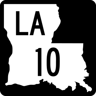
Louisiana Highway 10 (LA 10) is a state highway located in southern Louisiana. It runs 255.51 miles (411.20 km) in an east–west direction from U.S. Highway 171 (US 171) south of Leesville to the Mississippi state line east of Bogalusa.

<span class="mw-page-title-main">Louisiana Highway 25</span>

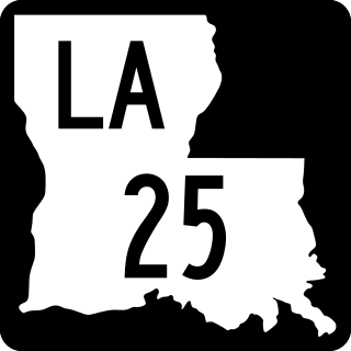
Louisiana Highway 25 (LA 25) is a state highway located in southeastern Louisiana. It runs 38.72 miles (62.31 km) in a north–south direction from U.S. Highway 190 (US 190) in Covington to the Mississippi state line north of Warnerton.

<span class="mw-page-title-main">Louisiana Highway 76</span>

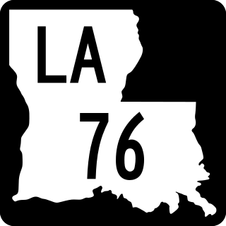
Louisiana Highway 76 (LA 76) is a state highway located in southeastern Louisiana. It runs 25.52 miles (41.07 km) in a general east–west direction from LA 77 in Maringouin to the junction of LA 1 and LA 987-4 in Port Allen.

<span class="mw-page-title-main">Louisiana Highway 415</span>

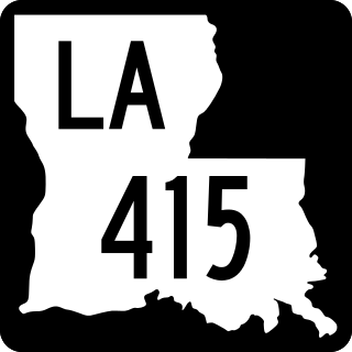
Louisiana Highway 415 is a state highway in Louisiana. It spans north–south through West Baton Rouge Parish and Pointe Coupee Parish for 25.3 miles (40.7 km).

<span class="mw-page-title-main">U.S. Route 11 in Louisiana</span>

U.S. Highway 11 (US 11) is a part of the United States Numbered Highway System that spans 1,645 miles (2,647 km) from New Orleans, Louisiana, to Rouses Point, New York. Within the state of Louisiana, the highway travels 31 miles (50 km) from the national southern terminus at US 90 in New Orleans to the Mississippi state line south of Picayune.

<span class="mw-page-title-main">U.S. Route 65 in Louisiana</span> Section of U.S. Highway in Louisiana, United States

U.S. Highway 65 (US 65) is a part of the United States Numbered Highway System that spans 966 miles (1,555 km) from Clayton, Louisiana to Albert Lea, Minnesota. Within the state of Louisiana, the highway travels 100.77 miles (162.17 km) from the national southern terminus at US 425/LA 15 in Clayton to the Arkansas state line north of Lake Providence.

<span class="mw-page-title-main">U.S. Route 61/190 Business</span>

U.S. Highway 61/190 Business is a business route of both U.S. Route 61 and U.S. Route 190 in Louisiana that serves as a boulevard into downtown Baton Rouge. It spans 10.89 miles (17.53 km) in a southeast to northwest direction and it is signposted as Business 61/190, generally without directional shields. It follows parts of the former alignment of US 61/190 through Baton Rouge, which existed in downtown Baton Rouge from 1935 until 1960.

References

  1. "Huey P. Long Bridge Widening".
  2. Will Sentel (December 3, 2013), Old bridge getting new look, The Advocate, archived from the original on August 10, 2014, retrieved August 7, 2014
  3. 1 2 3 "Paint Party". The Riverside Reader. [Port Allen, LA] October 1, 2012. Pg. 1. Print
  4. "Port of Greater Baton Rouge". Archived from the original on June 14, 2006. Retrieved April 26, 2008.
  5. AA Roads - US Highway 190 Mississippi River Bridge Archived June 9, 2007, at the Wayback Machine
  6. John Weeks.com - Huey P. Long Bridge
  7. "Ask The Advocate: Questions about the U.S. 190 bridge". The Advocate. Retrieved January 1, 2022.
  8. "Historic Bridge Management Plan for the Old Mississippi River (Huey P. Long) Bridge" (PDF). Louisiana Department of Transportation and Development. Retrieved January 1, 2022.