
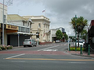
Inglewood is a town in the Taranaki Region of New Zealand's North Island. It is 16 kilometres (10 mi) southeast of New Plymouth on State Highway 3, close to Mount Taranaki, and sits 200 metres (660 ft) above sea level. The town services a mainly dairy farming region.
Eltham is a small inland town in South Taranaki, New Zealand, located 50 kilometres (31 mi) south of the city of New Plymouth and southeast of the volcanic cone of Mount Taranaki/Egmont. Stratford is 11 kilometres (6.8 mi) north, Kaponga 13 km west, and Hāwera is 19 km (12 mi) south. State Highway 3 runs through the town.

Waitara is a town in the northern part of the Taranaki region of the North Island of New Zealand. Waitara is located just off State Highway 3, 15 kilometres (9.3 mi) northeast of New Plymouth.

Ōkato is a small town in rural Taranaki, New Zealand. It is situated about 25 minutes drive around the coast from New Plymouth on State Highway 45. Oakura is 12 km to the north-east, and Warea is 9 km to the south-west. The place offers popular rocky surfing spots around coastal beaches. The town was established as a military settlement in the 1860s.

Ngaere is a village situated on State Highway 3, 4 kilometres (2.5 mi) south of Stratford, New Zealand. The name "Ngaere" literally means "swamp" in English, and before settlement, the area was covered by a vast and ancient wetland.
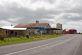
Douglas is a lowly populated locality and a rural centre in east Taranaki, surrounded by dairy, sheep and beef pastoral farming. It is situated 18 km east of Stratford at the intersection of East Road, Ohura Road, Douglas Road South and Bredow Road. East Road and Ohura Road meet to form State Highway 43, linking Stratford to the King Country town of Taumarunui. The Stratford–Okahukura Line, a secondary railway line, runs through Douglas where it veers north-east and away from the state highway for approximately 20 km.
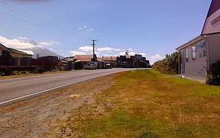
Toko is a small rural settlement 10 kilometres east of Stratford, New Zealand, at the intersection of East Road and Toko Road. It is located on a railway, the Stratford–Okahukura Line, the western portion of which was operated as a branch line known as the Toko Branch prior to the line's completion. The Toko Stream flows through the area to join the Patea River.
Lepperton is a small village in North Taranaki, New Zealand. It is approximately 6 km (3.7 mi) inland from Waitara township, 5 km (3.1 mi) west of the Waitara River, and 1 km (0.62 mi) east of State Highway 3A, which connects Inglewood to Waitara.
Tututawa is a locality and rural centre in east Taranaki, New Zealand, 26 kilometres (16 mi) east of Stratford, with a population of approximately 40. The settlement is centred 5 kilometres (3.1 mi) south of Ohura Road, at the intersection of Mangaotuku Road and Tututawa Road. Positioned approximately 150 metres (490 ft) above sea level, Tututawa is nestled in a valley amongst high sandstone and greywacke ridgelines. Within the area are the historic localities of Tewheniwheni, Mangaehu and Tawhiwhi.
Midhirst is a small village in Taranaki, New Zealand, approximately 4 km north of Stratford, on State Highway 3. Inglewood is 17 km (11 mi) north of Midhirst, and New Plymouth is 35 km (22 mi) to the northwest.

Ōakura is a small township in New Plymouth District, Taranaki, in the western North Island of New Zealand. It is located on State Highway 45, 15 kilometres south-west of New Plymouth. Ōkato is 12 km further south-west. The Oakura River flows past the town and into the North Taranaki Bight. To the south is the Kaitake Range, part of Egmont National Park.
Hurleyville is a community in south Taranaki, in the western North Island of New Zealand. It is located 18 kilometres north of Patea and 30 km southeast of Hāwera.
Alton is a small rural community in south Taranaki, in the western North Island of New Zealand. It is located between the towns of Hāwera and Patea.
Strathmore is a settlement in inland Taranaki, in the western North Island of New Zealand. It is located on State Highway 43, 25 kilometres (16 mi) east of Stratford.
Cardiff is a settlement in inland Taranaki, in the western North Island of New Zealand. It is located five kilometres southwest of Stratford close to Egmont National Park.
Tongapōrutu is a settlement in northern Taranaki, in the North Island of New Zealand. It is located on State Highway 3 at the mouth of the Tongaporutu River, 15 kilometres south of Mokau. Tongapōrutu is well known in New Zealand for its 'Three Sisters' rock formations and its Māori petroglyphs carved into cave rock walls. However, both the Māori rock carvings and the 'Three Sisters formations are constantly being eroded by the Tasman Sea.
Purangi is a locality east of Inglewood, New Zealand, situated on the banks of the Waitara River. It is within the traditional tribal lands of Ngāti Maru iwi. Today, Ngāti Maru's headquarters are at Tarata. The Marae is called Te Upoko o te Whenua.
Auroa is a locality in southern Taranaki. Opunake is to the west, Kaponga to the northeast, and Manaia to the southeast. Mount Taranaki is directly north of Auroa.
Ahititi is a locality in Taranaki, New Zealand. State Highway 3 runs through it. Mokau is 23 km to the north, Mimi is 26 km to the south-west, and Kotare is 16 km to the east. The Tongaporutu River flows through the area and into the North Taranaki Bight at Tongaporutu to the north-west. The name means "fire for cooking" (ahi) "muttonbirds" (titi).
Uruti is a locality in northern Taranaki, in the North Island of New Zealand. It is located on State Highway 3, north-east of Mimi and south-west of Ahititi. The Uruti Stream meets the Mimi River at this point. The river flows past the settlement into the North Taranaki Bight.
