Related Research Articles

Morelos, officially the Free and Sovereign State of Morelos, is one of the 32 states which comprise the Federal Entities of Mexico. It is divided into 36 municipalities and its capital city is Cuernavaca.
Ciudad Ayala is a city in the east-central part of the Mexican state of Morelos. It stands at 18°45′59″N98°59′05″W, at a mean height of 1,220 m (4,000 ft) above sea level. The city is named for Coronel Francisco Ayala (1760-1812) who fought with José María Morelos during the 1812 Siege of Cuautla. The town's previous name was Mapachtlan. Ayala became a municipality on April 17, 1869.
Coatlán del Río is a town in the Mexican state of Morelos. It stands at 18°45′N99°26′W, at a mean height of 1,010 metres above sea level.

Cuautla, officially La heroica e histórica Cuautla, Morelos or H. H. Cuautla, Morelos, is a city and municipality in the Mexican state of Morelos, about 104 kilometers south of Mexico City. In the 2010 census the city population was 154,358. The municipality covers 153.651 km2 (59.325 sq mi). Cuautla is the third most populous city in the state, after Cuernavaca and Jiutepec. The city was founded on April 4, 1829. The 2020 population figures were 187,118 inhabitants for the municipality and 157,336 inhabitants for the city of Cuatula.
Jantetelco, officially Jantetelco de Matamoros, is a city in the Mexican state of Morelos. . The city serves as the municipal seat for the surrounding municipality of the same name. The municipality reported 17,238 inhabitants in the year 2015 census.
Jiutepec is a city and its surrounding municipality in the Mexican state of Morelos.
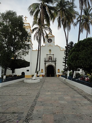
Jojutla is a municipality in the state of Morelos, Mexico. Its municipal seat is the city of Jojutla de Juárez. The name Jojutla comes from Nahuatl Xoxōuhtlān and means, Place of abundant blue skies. Another interpretation is Jojutla should be written Xo-Xoutla and its etymological roots come from: xoxou-ki, and Tla-ntli, (teeth) to indicate abundance, so the name means: Place abundant in blue paint. This meaning is corroborated by Father José Agapito Mateo Minos in Nohualco Tlalpixtican (1722), about how he saw the maceration and decanting tanks of the xoxouki plant, when it still existed in the plaza Zacate. Ángela Peralta mentions a unique pyramid consisting of three parts: the momozok, the turret and the campanile (tower), demolished by the colonial government. Remnants of this can be seen in the staircase of the municipal palace.
Mazatepec is a city in the Mexican state of Morelos..
Ocuituco is a town in the Mexican state of Morelos and the municipal head for the Municipality of Ocuituco which includes the towns of Ocuituco, Huejotengo, Huecahuaxco, Huepalcalco, Metepec, and Ocoxaltepec, as well as a number of settlements with fewer than 300 inhabitants. The name comes from Nahuatl Okuiltoco and means Where there are weevils. It is one of the 36 municipalities of the state of Morelos. To the north of Ocuitico is México State, southeast is Zacualpan, east is Tetela del Volcán, and southwest is Yecapixtla. It stands at 18°52′N98°46′W, at 1,920 meters above sea level. It is considered one of the municipalities of the "Los altos de Morelos".

Puente de Ixtla is a city in the Mexican state of Morelos. It stands at 18°37′01″N99°19′23″W. The city serves as the municipal seat for the surrounding municipality of the same name. The municipality reported 66,435 inhabitants in the year 2015 census.

Tepoztlán is a town in the central Mexican state of Morelos. It is located at 18°59′07″N99°05′59″W in the heart of the Tepoztlán Valley. The town serves as the seat of government for the municipality of the same name. The town had a population of 14,130 inhabitants, while the municipality reported 41,629 inhabitants in the 2010 national census.
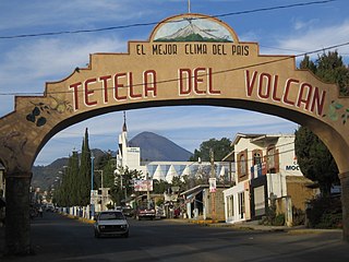
Tetela del Volcán or simply Tetela, is a town and municipal seat of the municipality of Tetela del Volcán in the Mexican state of Morelos. It is located on the slopes of the volcano Popocatépetl. 18°57′48″N99°15′12″W. The city serves as the municipal seat for the surrounding municipality of the same name. It is notable for its sixteenth century Dominican ex-convent which together with a number of other early monasteries nearby in the area has been declared a UNESCO World Heritage Site. The municipality reported 20,698 inhabitants in the year 2015 census. Other towns in the municipality of Tetela del Volcán include Hueyapan, Xochicalco and Tlamimilulpan.
Tlalnepantla is the name of a city and a municipality in the Mexican state of Morelos.
Totolapan is a municipality in the north of the Mexican state of Morelos, surrounded by the State of Mexico to the north; to the south with Tlayacapan and Atlatlahucan; to the east and southeast with Atlatlahucan; and to the west with Tlalnepantla.
Federal Highway 95 connects Mexico City to Acapulco, Guerrero. The Autopista del Sol is a tolled alternative, which bypasses several towns of the state of Guerrero, including the city Iguala, and thus reduces transit time between Acapulco from Mexico city from 8 hours to almost 3.5 hours.
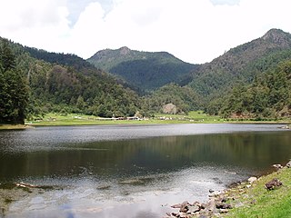
Lagunas de Zempoala National Park is a natural protected area in Mexico that consists of a group of seven lagoons. In the Nahuatl language, "Zempoala" means "place of many waters." The park is located between the state of Morelos and the state of Mexico.
Xoxocotla is a town located in the southern part of the state of Morelos, about 30 km south of the state capital Cuernavaca. The name comes from the Nahuatl language, Xoxo-oco-tlan: “place where there are green pines". Formerly part of Puente de Ixtla, it became its own indigenous municipality on 1 January 2019. It recorded a population of 21,074 inhabitants in the 2010 Mexican census.

Santa Maria Ahuacatitlán is a village in the municipality of Cuernavaca, in the state of Morelos, Mexico. Ahuacatitlán means "place among aguacates" (avocados).

The Sierra del Ajusco-Chichinauhtzin, also known as Serranía del Ajusco or Sierra de Chichinauhtzin, is a Mexican mountain range located between Mexico City and the states of Morelos and Mexico. It makes up the southern part of the mountain necklace that surrounds Mexico City. It is made up of more than one hundred volcanic cones, among which are: Tláloc, Chichinauhtzin (3,430 metres, Xitle (3,100 metres, Cerro Pelado (3,600 metres and Cuauhtzin (3,510 metres. Its maximum height is at the Cruz del Marqués peak on the Ajusco volcano.
The Cuernavaca Municipality is one of 36 municipalities in the State of Morelos, Mexico. Located in the northwest of the state, it consists of the City of Cuernavaca, which is the state and municipal capital, as well as other, smaller towns. The population is 378,476 (2020).
References
- ↑ http://cuentame.inegi.org.mx/monografias/informacion/mor/poblacion/default.aspx (Dec 13, 2018)
- ↑ impepac.mx(PDF) http://impepac.mx/wp-content/uploads/2018/07/Candidatos-electos-2018.pdf . Retrieved Dec 14, 2018.
{{cite web}}: Missing or empty|title=(help)[ title missing ] - ↑ 2010 census tables: INEGI Archived 2013-05-02 at the Wayback Machine
- ↑ Ríos Szalay, Adalberto. El Estado de Morelos, Reproducciones Fotomecánicas, Mexico. (1997), p. 76
- ↑ "Sentencian a policías federales por ataque a agentes de la CIA en Tres Marías en 2012" [Federal police sentenced for attack on CIA in Tres Marias in 2012]. Diario de Morelos (in Spanish). Cuernavaca. June 18, 2019. Retrieved July 8, 2019.
- ↑ "Confirman 505 contagios de COVID-19 y 59 defunciones en Morelos". www.notimex.gob.mx (in Spanish). Retrieved May 9, 2020.
- ↑ Redacción, La. "Situación actual del coronavirus Covid-19 en Morelos" [Present situation of coronavirus COVID-19 in Morelos]. www.launion.com.mx (in European Spanish). Retrieved Apr 29, 2020.
- ↑ "Coronavirus en Morelos | Diario de Morelos". www.diariodemorelos.com (in Spanish). Retrieved June 4, 2020.
- ↑ "Abandonan material infeccioso hospitalario en carreteras de Morelos y Puebla: Capufe | Video". www.msn.com. Retrieved June 12, 2020.
- ↑ Preciado, Tlaulli. "En Morelos, cinco mil 319 casos confirmados acumulados de covid-19 y mil 27 decesos". La Unión (in European Spanish). Retrieved September 1, 2020.
- ↑ "Llega Morelos a 1 mil 600 muertes por COVID19". diariodemorelos.com (in Spanish). Diario de Morelos. December 27, 2020. Retrieved December 28, 2020.
- ↑ "Corredor Biológico Chichinautzin". Gobierno de Mexico. Retrieved 2019-10-10.
- ↑ "Dos fiestas en honor a San Juan Bautista" (PDF). Pulso de la Provincia. franciscanosenmexico.com.mx. Retrieved 2014-12-14.
- ↑ "Los-Columpios".
- ↑ "Monumento de José María Morelos y Pavón, en Huitzilac". 31 July 2014. Retrieved 2018-12-14.
- 1 2 "Huitzilac−Morelos" [Huitzilac−Morelos] (in Spanish). Huitzilac.com. Retrieved March 1, 2019.
- ↑ http://morelos.gob.mx/?q=huitzilac (Dec 15, 2018)
- 1 2 3 4 5 6 Relieve del Estado de Morelos accessed May 9, 2020
