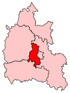
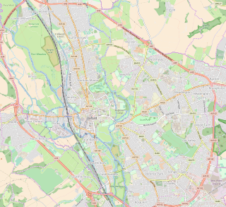
Hormer was an ancient hundred of Berkshire, England. It consisted of the area immediately west of Oxford within the bend of the River Thames, all of which was transferred to Oxfordshire on 1 April 1974 in accordance with the Local Government Act 1972. It included the ancient parishes of

Berkshire is a county in South East England. One of the home counties, Berkshire was recognised by the Queen as the Royal County of Berkshire in 1957 because of the presence of Windsor Castle, and letters patent were issued in 1974. Berkshire is a county of historic origin, a ceremonial county and a non-metropolitan county without a county council. The county town is Reading.

Oxford is a university city in Oxfordshire, England, with a population of 155,000. It is 51 miles (82 km) northwest of London, 57 miles (92 km) from Birmingham and 30 miles (48 km) from Reading.

The River Thames, known alternatively in parts as the Isis, is a river that flows through southern England including London. At 215 miles (346 km), it is the longest river entirely in England and the second-longest in the United Kingdom, after the River Severn.
- Abingdon
- Besselsleigh
- Cumnor
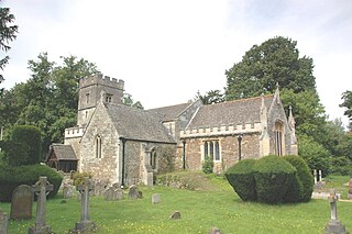
- North Hinksey
- South Hinksey
- Radley
- Seacourt
- Sunningwell
- Wootton
- Wytham
- St. Helen (part)

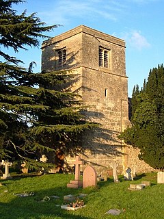
Besselsleigh or Bessels Leigh is a village and civil parish about 4 1⁄2 miles (7 km) south-west of Oxford. Besselsleigh was part of Berkshire until the 1974 boundary changes transferred it to Oxfordshire.

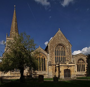
Cumnor is a village and civil parish 3.5 miles (5.6 km) west of the centre of Oxford, England. The parish of Cumnor includes Cumnor Hill,, Chawley, the Dean Court area on the edge of Botley and the outlying settlements of Chilswell, Farmoor, Filchampstead and Swinford. The parish was part of Berkshire until the 1974 local government boundary changes transferred it to Oxfordshire.
North Hinksey is a village and civil parish in Oxfordshire, England, immediately west of Oxford. The civil parish includes the large settlement of Botley, effectively a suburb of Oxford. North Hinksey was part of Berkshire until the 1974 boundary changes transferred it to Oxfordshire.
The hundred also included the almost uninhabited extra-parochial area of Bagley Wood, which became a civil parish in 1858 and was joined to Radley in 1900. [1]
In England and Wales, an extra-parochial area, extra-parochial place or extra-parochial district was a geographically defined area considered to be outside any ecclesiastical or civil parish. Anomalies in the parochial system, they had no church or clergymen and were therefore exempt from payment of poor or church rates and usually tithes. They were formed for a variety of reasons, often because an area was unpopulated or unsuitable for agriculture, but also around institutions and buildings or natural resources. Extra-parochial areas caused considerable problems when they became inhabited as they did not provide religious facilities, local governance or provide for the relief of the poor. Their status was often ambiguous and there was demand for extra-parochial areas to operate more like parishes. Following the introduction of the New Poor Law, extra-parochial areas were effectively made civil parishes by the Extra-Parochial Places Act 1857 and were eliminated by the Poor Law Amendment Act 1868. This was achieved either by being integrated with a neighbouring or surrounding parish, or by becoming a separate civil parish if the population was high enough.
Bagley Wood is a wood in the parish of Kennington between Oxford and Abingdon in Oxfordshire, England. It is traversed from north to south by the A34 road, which was rerouted through the wood in 1972.

In England, a civil parish is a type of administrative parish used for local government, they are a territorial designation which is the lowest tier of local government below districts and counties, or their combined form, the unitary authority. Civil parishes can trace their origin to the ancient system of ecclesiastical parishes which historically played a role in both civil and ecclesiastical administration; civil and religious parishes were formally split into two types in the 19th century and are now entirely separate. The unit was devised and rolled out across England in the 1860s.
The name of the hundred is derived from what was presumably its original meeting place, an unidentified Horningamere "pool of the Hornings". The Hornings were the people who lived in the "horn", the angle of land in Berkshire enclosed by the bend of the Thames. [2]
The hundred came into existence before the time of the Domesday Book in 1086, when it had the same area except for the parish of Besselsleigh, which joined the hundred by 1321. In 1086 the entire hundred belonged to Abingdon Abbey. The court of the hundred met at Bagley Wood, and later at Cumnor. [3]

Domesday Book is a manuscript record of the "Great Survey" of much of England and parts of Wales completed in 1086 by order of King William the Conqueror. The Anglo-Saxon Chronicle states:
Then, at the midwinter [1085], was the king in Gloucester with his council .... After this had the king a large meeting, and very deep consultation with his council, about this land; how it was occupied, and by what sort of men. Then sent he his men over all England into each shire; commissioning them to find out "How many hundreds of hides were in the shire, what land the king himself had, and what stock upon the land; or, what dues he ought to have by the year from the shire."

Abingdon Abbey was a Benedictine monastery also known as St Mary's Abbey located in Abingdon, historically in the county of Berkshire but now in Oxfordshire, England.