Hunterville

Last updated

Hunterville
Hunterway.JPG
Monument paying tribute to Huntaway dogs at Hunterville
Hunterville
Coordinates: 39°56′S175°34′E / 39.933°S 175.567°E / -39.933; 175.567
CountryNew Zealand
Region Manawatū-Whanganui
District Rangitikei District
Wards
  • Central General Ward
  • Tiikeitia ki Uta (Inland) Māori Ward
Electorates
Government
  Territorial Authority Rangitikei District Council
  Regional council Horizons Regional Council
Area
[1]
  Total3.22 km2 (1.24 sq mi)
Population
 (June 2022) [2]
  Total420
  Density130/km2 (340/sq mi)

Hunterville is a small town in the Rangitikei district of the North Island of New Zealand. It is located halfway between Taupo and Wellington on State Highway 1, and as of the 2018 census has a population of 408. [3]

Contents

The township was named for George Hunter, who was a member of the Wellington Provincial Council. [4] It straddles the state highway as well as the main trunk railway in the foothills forming the gateway to the Central Plateau.

Kiwiburn, the New Zealand Burning Man regional burn, has been held there since 2014.

The Hunterville railway station on the North Island Main Trunk line opened in 1887 and closed in 1988.

The closest airport or airfield to Hunterville is RNZAF Base Ohakea, an important Royal New Zealand Air Force base, which is sited 33 km to the south west. 6 km north of Hunterville is Vinegar Hill.

Hunterville is well known for its statue of the huntaway, a specialised herding dog that uses its voice to drive the sheep. The town festival and market held on the first Saturday after Labour Day has a "Shepherds Shemozzle" – a race with man and dog with shepherds travelling from all over New Zealand to compete for the top prize. [5]

There are marae south of the town at Rātā, which are affiliated with Ngāti Hauiti hapū. Tāhuhu Marae (or Taahuhu Marae) and Te Ruku a Te Kawau meeting house is a meeting place for Ngāti Haukaha. Rātā or Te Hou Hou or Potaka Marae and Hauiti meeting house are affiliated with Ngāti Ruaanga and Ngāti Tamateraka. [6] [7]

From at least 1895 [8] to 1948 the Hunterville Express was published in the town. [9] It was one of 45 newspapers founded by Joseph Ives. [10] Other editors were Cuthbert James Powell, [11] [12] Walter Keay, [13] who was also a novelist [14] and whose wife had earlier signed a suffrage petition in 1893, when women first gained a vote. [15] In 1905 it was the Hunterville Express and Upper Rangitikei Advertiser, published 3 times a week. [16] The Express offices were burnt out in 1917. [17]

Demographics

Hunterville is defined by Statistics New Zealand as a rural settlement. It covers 3.22 km2 (1.24 sq mi) [1] and had an estimated population of 420 as of June 2022, [2] with a population density of 130 people per km2. It is part of the larger Otairi statistical area.

Historical population for Hunterville
YearPop.±% p.a.
2006444    
2013432−0.39%
2018408−1.14%
Source: [3]
Aerial photo of Hunterville Hunterville from the air.jpg
Aerial photo of Hunterville
Hunterville Courthouse Hunterville Courthouse (5657442748).jpg
Hunterville Courthouse

Hunterville had a population of 408 at the 2018 New Zealand census, a decrease of 24 people (−5.6%) since the 2013 census, and a decrease of 36 people (−8.1%) since the 2006 census. There were 183 households, comprising 213 males and 201 females, giving a sex ratio of 1.06 males per female, with 75 people (18.4%) aged under 15 years, 60 (14.7%) aged 15 to 29, 165 (40.4%) aged 30 to 64, and 108 (26.5%) aged 65 or older.

Ethnicities were 83.1% European/Pākehā, 21.3% Māori, 2.9% Asian, and 5.1% other ethnicities. People may identify with more than one ethnicity.

Although some people chose not to answer the census's question about religious affiliation, 55.9% had no religion, 30.9% were Christian, 0.7% had Māori religious beliefs and 1.5% had other religions.

Of those at least 15 years old, 36 (10.8%) people had a bachelor's or higher degree, and 84 (25.2%) people had no formal qualifications. 21 people (6.3%) earned over $70,000 compared to 17.2% nationally. The employment status of those at least 15 was that 132 (39.6%) people were employed full-time, 63 (18.9%) were part-time, and 18 (5.4%) were unemployed. [3]

Otairi statistical area

Otairi covers 636.74 km2 (245.85 sq mi) [1] and had an estimated population of 1,330 as of June 2022, [18] with a population density of 2.1 people per km2.

Historical population for Otairi
YearPop.±% p.a.
20061,287    
20131,227−0.68%
20181,272+0.72%
Source: [19]

Otairi had a population of 1,272 at the 2018 New Zealand census, an increase of 45 people (3.7%) since the 2013 census, and a decrease of 15 people (−1.2%) since the 2006 census. There were 510 households, comprising 654 males and 618 females, giving a sex ratio of 1.06 males per female. The median age was 43.0 years (compared with 37.4 years nationally), with 252 people (19.8%) aged under 15 years, 213 (16.7%) aged 15 to 29, 555 (43.6%) aged 30 to 64, and 249 (19.6%) aged 65 or older.

Ethnicities were 86.6% European/Pākehā, 19.1% Māori, 0.9% Pacific peoples, 1.9% Asian, and 3.3% other ethnicities. People may identify with more than one ethnicity.

The percentage of people born overseas was 10.4, compared with 27.1% nationally.

Although some people chose not to answer the census's question about religious affiliation, 51.9% had no religion, 37.7% were Christian, 1.2% had Māori religious beliefs and 1.4% had other religions.

Of those at least 15 years old, 150 (14.7%) people had a bachelor's or higher degree, and 231 (22.6%) people had no formal qualifications. The median income was $26,900, compared with $31,800 nationally. 126 people (12.4%) earned over $70,000 compared to 17.2% nationally. The employment status of those at least 15 was that 525 (51.5%) people were employed full-time, 180 (17.6%) were part-time, and 27 (2.6%) were unemployed. [19]

Education

Hunterville Consolidated School is a co-educational state primary school for Year 1 to 8 students, [20] [21] with a roll of 106 as of April 2023. [22]

Notable people

Related Research Articles

<span class="mw-page-title-main">Ngāruawāhia</span> Town in Waikato, New Zealand

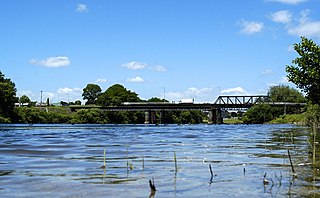
Ngāruawāhia is a town in the Waikato region of the North Island of New Zealand. It is located 20 kilometres (12 mi) north-west of Hamilton at the confluence of the Waikato and Waipā Rivers, adjacent to the Hakarimata Range. Ngāruawāhia is in the Hamilton Urban Area, the fourth largest urban area in New Zealand. The location was once considered as a potential capital of New Zealand.

<span class="mw-page-title-main">Taihape</span> Town in Manawatū-Whanganui, New Zealand

Taihape is in the Rangitikei District of the North Island of New Zealand. It serves a large rural community. State Highway 1, which runs North to South through the centre of the North Island, passes through the town.

<span class="mw-page-title-main">Te Awamutu</span> Town in Waikato, New Zealand

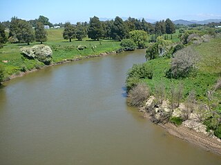
Te Awamutu is a town in the Waikato region in the North Island of New Zealand. It is the council seat of the Waipa District and serves as a service town for the farming communities which surround it. Te Awamutu is located some 30 kilometres (19 mi) south of Hamilton on State Highway 3, one of the two main routes south from Auckland and Hamilton.

<span class="mw-page-title-main">Tuakau</span> Place in Waikato, New Zealand

Tuakau is a town in the Waikato region at the foot of the Bombay Hills, formerly part of the Franklin District until 2010, when it became part of Waikato District in the North Island of New Zealand. The town serves to support local farming, and is the residence of many employees of New Zealand Steel at Glenbrook.

<span class="mw-page-title-main">Bulls, New Zealand</span> Town in Manawatū-Whanganui, New Zealand

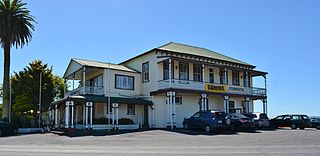
Bulls is a town in the Rangitikei District of New Zealand. It is in a fertile farming area at the junction of State Highways 1 and 3, 28 km (17 mi) northwest of Palmerston North. According to a June 2022 Statistics New Zealand estimate, Bulls has a population of 2,190 inhabitants.

<span class="mw-page-title-main">Tīrau</span> Settlement in Waikato, New Zealand

Tīrau is a small town in the Waikato region of the North Island of New Zealand, 50 kilometres southeast of Hamilton. The town has a population of 804. In the Māori language, "Tīrau" means "place of many cabbage trees."

<span class="mw-page-title-main">Ōtorohanga</span> Town in Waikato, New Zealand

Ōtorohanga is a north King Country town in the Waikato region in the North Island of New Zealand. It is located 53 kilometres (33 mi) south of Hamilton and 18 kilometres (11 mi) north of Te Kūiti, on the Waipā River. It is a service town for the surrounding dairy-farming district. It is recognised as the "gateway" to the Waitomo Caves and as the "Kiwiana Town" of New Zealand. Until 2007, Ōtorohanga held a yearly 'Kiwiana Festival.'

<span class="mw-page-title-main">Takapau</span> Settlement in Hawkes Bay Region, New Zealand

Takapau is a small rural community in the Central Hawkes Bay in New Zealand. It is located 20 kilometres west of Waipukurau, off State Highway 2, and has a population of more than 500.

<span class="mw-page-title-main">Waipawa</span> Town in Hawkes Bay, New Zealand

Waipawa is the second-largest town in Central Hawke's Bay in the east of the North Island of New Zealand. It has a population of 2,400.

<span class="mw-page-title-main">Tolaga Bay</span> Town in Gisborne District, New Zealand

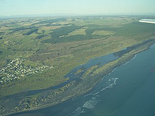
Tolaga Bay is both a bay and small town on the East Coast of New Zealand's North Island located 45 kilometres northeast of Gisborne and 30 kilometres south of Tokomaru Bay.

<span class="mw-page-title-main">Kawhia Harbour</span> Harbour and settlement in Waikato, New Zealand

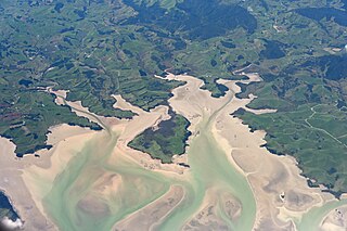
Kawhia Harbour is one of three large natural inlets in the Tasman Sea coast of the Waikato region of New Zealand's North Island. It is located to the south of Raglan Harbour, Ruapuke and Aotea Harbour, 40 kilometres southwest of Hamilton. Kawhia is part of the Ōtorohanga District and is in the King Country. It has a high-tide area of 68 km2 (26 sq mi) and a low-tide area of 18 km2 (6.9 sq mi). Te Motu Island is located in the harbour.

<span class="mw-page-title-main">Putāruru</span> Town in Waikato, New Zealand

Putāruru is a small town in the South Waikato District and the Waikato region of New Zealand's North Island. It lies on the western side of the Mamaku Ranges and in the upper basin of the Waihou River. It is on the Oraka Stream 65 kilometres south-east of Hamilton. State Highway 1 and the Kinleith Branch railway run through the town.

<span class="mw-page-title-main">Te Kauwhata</span> Town in Waikato, New Zealand

Te Kauwhata is a small town in the north of the Waikato region of New Zealand, situated close to the western shore of Lake Waikare, some 40 km north of Hamilton and approximately 58 km south of Manukau City.

Waharoa is a rural community in the Waikato region of New Zealand's North Island. It is located 7 km north of Matamata, and is part of the Matamata-Piako District. It is located at the junction of the Kinleith Branch railway and the East Coast Main Trunk Railway. State Highway 27 runs through the town, which is serviced by several shops and cafes and by a petrol station. Matamata Airport is just over 3 km (1.9 mi) north of Waharoa.

<span class="mw-page-title-main">Halcombe</span> Settlement in Manawatū-Whanganui Region, New Zealand

Halcombe is a small settlement in the Manawatū-Whanganui region of the North Island, New Zealand. It is situated 13 km north west of Feilding and 4 km east of the Rangitikei River, between State Highway 1 and State Highway 54.

<span class="mw-page-title-main">Whatawhata</span> Town in Waikato, New Zealand

Whatawhata, previously also spelt Whata Whata, is a small town in the Waikato region on the east bank of the Waipā River, at the junction of State Highways 23 and 39, 12 km (7.5 mi) from Hamilton. Te Araroa tramping route passes through Whatawhata.

<span class="mw-page-title-main">Rangiriri</span> Settlement in Waikato, New Zealand

Rangiriri is a rural community in the Waikato District and Waikato region of New Zealand's North Island. It is located on the Waikato River near Lake Waikare in the Waikato District. State Highway 1 now bypasses Rangiriri.

<span class="mw-page-title-main">Koitiata</span> Settlement in Manawatū-Whanganui Region, New Zealand

Koitiata is a settlement located in the southwestern part of Rangitikei District of the Manawatū-Whanganui region of New Zealand's North Island. At the time of the 2018 census, Koitiata had a population of 126. Marton is located 24 km to the east and Whanganui is located 29 km to the northwest. Nearby Koitiata is Lake Koitiata.

Okauia is a rural settlement and community located east of Matamata, in the Waikato region of New Zealand's North Island.

<span class="mw-page-title-main">Mourea</span> Rural settlement in Bay of Plenty Region, New Zealand

Mourea is a settlement in Rotorua Lakes within the Bay of Plenty Region of New Zealand's North Island.

References

  1. 1 2 3 "ArcGIS Web Application". statsnz.maps.arcgis.com. Retrieved 10 April 2021.
  2. 1 2 "Subnational population estimates (RC, SA2), by age and sex, at 30 June 1996-2022 (2022 boundaries)". Statistics New Zealand . Retrieved 25 October 2022. (regional councils); "Subnational population estimates (TA, SA2), by age and sex, at 30 June 1996-2022 (2022 boundaries)". Statistics New Zealand . Retrieved 25 October 2022. (territorial authorities); "Subnational population estimates (urban rural), by age and sex, at 30 June 1996-2022 (2022 boundaries)". Statistics New Zealand . Retrieved 25 October 2022. (urban areas)
  3. 1 2 3 "Statistical area 1 dataset for 2018 Census". Statistics New Zealand. March 2020. 7017965–7017967.
  4. Discover New Zealand - A Wises Guide (9 ed.). Wises Publications Limited. 1994. p. 230.
  5. "Hunterville's 'Shepherds' Shemozzle'". Radio.co.nz. 2 November 2015. Retrieved 30 June 2016.
  6. "Te Kāhui Māngai directory". tkm.govt.nz. Te Puni Kōkiri.
  7. "Māori Maps". maorimaps.com. Te Potiki National Trust.
  8. "OUR EDUCATION SYSTEM. POVERTY BAY HERALD". paperspast.natlib.govt.nz. 9 January 1895. Retrieved 22 August 2021.
  9. "OTAGO DAILY TIMES". paperspast.natlib.govt.nz. 17 August 1948. Retrieved 22 August 2021.
  10. "OBITUARY. ASHBURTON GUARDIAN". paperspast.natlib.govt.nz. 6 September 1919. Retrieved 22 August 2021.
  11. "PERSONAL PARAGRAPHS. MANAWATU TIMES". paperspast.natlib.govt.nz. 16 August 1921. Retrieved 22 August 2021.
  12. "OBITUARY. MANAWATU HERALD". paperspast.natlib.govt.nz. 9 February 1935. Retrieved 22 August 2021.
  13. "OBITUARY. OTAGO DAILY TIMES". paperspast.natlib.govt.nz. 15 November 1945. Retrieved 22 August 2021.
  14. "Reed Gallery". www.reedgallery.co.nz. Retrieved 22 August 2021.
  15. "Mrs Keay". nzhistory.govt.nz. Retrieved 22 August 2021.
  16. "New Zealand Official Yearbook 1905".
  17. "RANGITIKEI ADVOCATE AND MANAWATU ARGUS". paperspast.natlib.govt.nz. 11 August 1917. Retrieved 22 August 2021.
  18. "Population estimate tables - NZ.Stat". Statistics New Zealand . Retrieved 25 October 2022.
  19. 1 2 "Statistical area 1 dataset for 2018 Census". Statistics New Zealand. March 2020. Otairi (226400). 2018 Census place summary: Otairi
  20. "Official School Website". hunterville.school.nz.
  21. "Ministry of Education School Profile". educationcounts.govt.nz. Ministry of Education.
  22. "Education Review Office Report". ero.govt.nz. Education Review Office.
  23. Grover, Ray. "William Meldrum". Dictionary of New Zealand Biography . Ministry for Culture and Heritage . Retrieved 1 December 2011.