Hurley, Mississippi | |
|---|---|
 Location of Hurley, Mississippi | |
 Hurley, Mississippi Location in the United States | |
| Coordinates: 30°39′48″N88°29′58″W / 30.66333°N 88.49944°W | |
| Country | |
| State | |
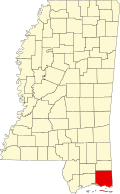
| County | Jackson |
| Area | |
• Total | 5.15 sq mi (13.34 km2) |
| • Land | 5.14 sq mi (13.30 km2) |
| • Water | 0.015 sq mi (0.04 km2) |
| Elevation | 102 ft (31 m) |
| Population (2020) | |
• Total | 1,557 |
| • Density | 303.2/sq mi (117.07/km2) |
| Time zone | UTC-6 (Central (CST)) |
| • Summer (DST) | UTC-5 (CDT) |
| ZIP code | 39555 |
| Area code | 228 |
| FIPS code | 28-34340 |
| GNIS feature ID | 0671597 |
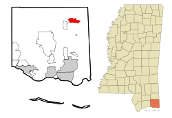
Hurley is an unincorporated community and census-designated place (CDP) in Jackson County, Mississippi, United States. It is part of the Pascagoula Metropolitan Statistical Area. The population was 1,551 at the 2010 census, [2] up from 985 at the 2000 census.