Hurworth Place

Last updated

Hurworth Place
Hurworth place.jpg
Hurworth Place and Croft Bridge, from the opposite bank of the River Tees
Durham UK location map.svg
Red pog.svg
Hurworth Place
Location within County Durham
OS grid reference NZ2931809833
Civil parish
Unitary authority
Ceremonial county
Region
Country England
Sovereign state United Kingdom
Police Durham
Fire County Durham and Darlington
Ambulance North East
UK Parliament
List of places
UK
England
County Durham
54°28′59″N1°32′56″W / 54.483°N 1.549°W / 54.483; -1.549

Hurworth Place is a village in County Durham, in England. It lies south of Darlington on the northern bank of the River Tees, opposite the village of Croft-on-Tees in North Yorkshire to which it is linked by Croft Bridge, a Grade I listed structure dating from the 14th century, which marks the county boundary. [1] It is part of the civil parish of Hurworth.

Contents

Transport

The Great North Road mail coach route, later the A1 road, originally passed through the village, crossing the Tees via Croft Bridge. It was later rerouted, and the road is now designated the A167. The Teesdale Way footpath runs through the village, as does the East Coast Main Line, although there is no longer a railway station.

Amenities

The village has a newsagent, a doctor's surgery, a garage, a pharmacy, and a hair salon. There is a working men's club, and one pub called the Comet, named after a shorthorn bull. There is also a Christadelphian hall. [2] Rockliffe Hall hotel and spa and the surrounding parkland are owned by Middlesbrough Football Club, and the club's training and sports facilities form part of the complex. [3] The 18-hole Rockliffe championship golf course is one of the longest in Europe. [4] The adjoining village of Hurworth-on-Tees contains further shops, a primary and secondary school, the parish church and a Methodist church, a garden centre, a fish and chip shop and a community centre.

History

Despite being in a different county, the settlement around the Durham end of Croft bridge has sometimes been identified as part of Croft village, rather than with Hurworth-on-Tees immediately to the east. In 1834 Hurworth Place was described as a hamlet in the township of Hurworth, growing rapidly under the influence of the railhead and coal depot; [5] however, in 1901, Charles G. Harper referred to Croft as "straggling on both the Yorkshire and Durham banks of the Tees". [6] As late as 1960, a long-time Croft resident referred to "the part of Croft which is called Hurworth Place". [7] The village began to develop around the time the railway arrived in 1829, [8] and in addition to a coal depot and goods yard, the low ground near the river housed at various times a tar works and two brick and tile works. [5] [7]

Railway

Croft Spa railway station in Hurworth Place, 1908 Croft Spa Station.jpg
Croft Spa railway station in Hurworth Place, 1908

In 1829 the Croft branch line was built by the Stockton and Darlington Railway Company from Darlington to Croft terminus on the north bank of the Tees in Hurworth Place. Coal was brought by rail from Darlington to the terminus for road transport to destinations in South Durham and North Yorkshire. Lead from the Swaledale lead mines was also brought to Croft terminus for onward rail transport. Passenger services ran at times on the line, but it was largely a goods route. [9] Workers' houses were built around the terminus. [5]

On 4 January 1841 the main line between Darlington and York opened, incorporating some of the original Darlington-Croft branch line, which had been bought by the main line's developers, the Great North of England Railway. Through Hurworth Place the new line ran, and still runs, a short distance east of the original line, which remained as a branch line to serve the Croft goods yard. In March 1841 a new Croft Station opened on the main line; this was renamed Croft Spa Station in 1896 acknowledging its role in bringing visitors to the popular and established spa over the bridge at Croft-on-Tees. The goods yard, now known as Croft Depot, remained in use until 1964, when it was demolished, the branch line taken up and the site redeveloped for residential use. Croft Spa station closed to passengers in 1969 and the platforms and station buildings were demolished. [9]

Related Research Articles

<span class="mw-page-title-main">Embsay and Bolton Abbey Steam Railway</span> Heritage railway in North Yorkshire, England

The Embsay and Bolton Abbey Steam Railway (E&BASR) is a heritage railway in North Yorkshire, England, formed in 1979 and opened in 1981.

<span class="mw-page-title-main">River Tees</span> East coast river of Northern England

The River Tees, in England, rises on the eastern slope of Cross Fell in the North Pennines and flows eastwards for 85 miles (137 km) to reach the North Sea in the North East of England. The modern day history of the river has been tied with the industries on Teesside in its lower reaches, where it has provided the means of import and export of goods to and from the North East England. The need for water further downstream also meant that reservoirs were built in the extreme upper reaches, such as Cow Green.

<span class="mw-page-title-main">Stockton and Darlington Railway</span> English railway company, 1825 to 1863

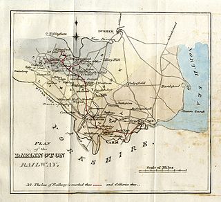
The Stockton and Darlington Railway (S&DR) was a railway company that operated in north-east England from 1825 to 1863. The world's first public railway to use steam locomotives, its first line connected collieries near Shildon with Darlington and Stockton in County Durham, and was officially opened on 27 September 1825. The movement of coal to ships rapidly became a lucrative business, and the line was soon extended to a new port at Middlesbrough. While coal waggons were hauled by steam locomotives from the start, passengers were carried in coaches drawn by horses until carriages hauled by steam locomotives were introduced in 1833.

<span class="mw-page-title-main">Merrybent</span> Human settlement in England

Merrybent is a linear village in the civil parish of Low Coniscliffe and Merrybent in County Durham, in England. It is situated on the A67 road to the west of Darlington, a short distance to the north of the River Tees and the Teesdale Way. At the beginning of the 20th century there were hardly any buildings here, and its main feature at that time was Merrybent Nurseries with its many glasshouses. The nursery was cut through by the A1 road in the 1960s; at this point it runs on the trackbed of the old Merrybent railway. The village is now a settlement of modern housing.

<span class="mw-page-title-main">Winston, County Durham</span> Village in County Durham, England

Winston is a village and civil parish in County Durham, England. It is situated approximately 6 miles (9.7 km) east of Barnard Castle, on a crossroads between the A67 and B6274 roads. According to the 2011 UK Census the population was 431, the parish includes the hamlets of Little Newsham and South Cleatlam.

<span class="mw-page-title-main">Hurworth-on-Tees</span> Human settlement in England

Hurworth-on-Tees is a village in the borough of Darlington, within the ceremonial county of County Durham, England. It is situated in the civil parish of Hurworth. The village lies to the south of Darlington on the River Tees, close to its meeting point with the River Skerne, and immediately adjoins the village of Hurworth Place, which forms part of the same civil parish.

<span class="mw-page-title-main">Borough of Darlington</span> Unitary authority area in County Durham, England

The Borough of Darlington is a unitary authority area with borough status in County Durham, England. It is named after the town of Darlington and in the Tees Valley mayoral area. The area borders three local authority areas; the County Durham district is to the north and west, Stockton-on-Tees to the east and North Yorkshire to the south, the River Tees forming the border for the latter. In 2011, the borough had a population of 106,000.

<span class="mw-page-title-main">Dalton-on-Tees</span> Village and civil parish in North Yorkshire, England

Dalton-on-Tees is a village and civil parish in North Yorkshire, England, near the boundary with County Durham. According to the 2001 Census there were 318 people living in the parish in 120 houses. The population had decreased to 303 by the time of the 2011 Census.

<span class="mw-page-title-main">Croft-on-Tees</span> Village and civil parish in North Yorkshire, England

Croft-on-Tees is a village and civil parish in North Yorkshire, England. It has also been known as Croft Spa, and from which the former Croft Spa railway station took its name. It lies 11 miles (18 km) north-north west of the county town of Northallerton.

<span class="mw-page-title-main">Thornaby TMD</span>

Thornaby TMD was a railway traction maintenance depot situated in Thornaby, England, latterly operated by DB Schenker. The depot was situated to the east of Thornaby, on the northern side of the line to Middlesbrough.

<span class="mw-page-title-main">River Skerne</span> River in County Durham, England

The River Skerne is a tributary of the River Tees. It flows through County Durham in England.

<span class="mw-page-title-main">Middleton Junction railway station</span> Former railway station in England

Middleton Junction railway station was an early junction station on the Manchester and Leeds Railway, it opened when the branch to Oldham opened in 1842.

<span class="mw-page-title-main">Croft Spa railway station</span> Former railway station in England

Croft Spa railway station was a railway station serving the settlements of Croft-on-Tees and Hurworth-on-Tees in County Durham, England.

<span class="mw-page-title-main">Eston railway station</span> Disused railway station in North Yorkshire, England

Eston railway station formerly served the North Yorkshire town of Eston. It was used as a passenger station between 1902 and 1929 and as a goods-only station until 1966. It was the terminus of a short spur that curved east from the Normanby Branch of the Middlesbrough and Redcar Railway. The Normanby Branch was the northern end of the former Cleveland Railway, which had been closed south of Normanby in 1873.

<span class="mw-page-title-main">Ferryhill railway station</span> Former railway station in England

Ferryhill railway station was located in Ferryhill, County Durham, Northeast England. It was located on what became the East Coast Main Line between Darlington and Durham, close to the junctions with several former branches, including the extant freight-only Stillington Line to Norton-on-Tees and Stockton.

<span class="mw-page-title-main">Tees Marshalling Yard</span> Railway marshalling yard in Middlesbrough, England

Tees Marshalling Yard is a railway marshalling yard, used to separate railway wagons, located near Middlesbrough in North Yorkshire, Northern England.

<span class="mw-page-title-main">Darlington and Barnard Castle Railway</span>

The Darlington and Barnard Castle Railway, was an east–west railway line that connected Darlington and Barnard Castle in County Durham, England. Besides the main running line, it had two branches that headed south into Yorkshire that were only used for freight. The whole system opened up by July 1856 and was closed completely by 1966. The former Merrybent freight branch is now used as part of the A1(M) road that bypasses to the west of Darlington.

Wynyard railway station was a railway station on the Castle Eden branch of the North Eastern Railway (NER) from 1880 to 1931. It was located immediately to the south of the bridge carrying the Hartlepool to Sedgefield road and served little more than a few scattered hamlets, including Embleton and Swainston. Despite its name, the station was poorly situated for Wynyard Park which was better served by the neighbouring station at Thorpe Thewles.

<span class="mw-page-title-main">Hurworth Burn railway station</span> Railway station on the Castle Eden branch of the North Eastern Railway from 1880 to 1931

Hurworth Burn railway station was a railway station on the Castle Eden branch of the North Eastern Railway (NER) from 1880 to 1931. It was located between the embankment carrying the railway over Hurworth Burn Reservoir and the bridge carrying the line over the Hart to Trimdon road. As well as serving the then relatively new reservoir, the station primarily served a few scattered hamlets though it was also the nearest station to the village of Sheraton.

<span class="mw-page-title-main">Winston railway station</span> Disused railway station in Winston, County Durham

Winston railway station served the village of Winston, County Durham, England, from 1856 to 1965 on the Darlington and Barnard Castle Railway.

References

  1. "Croft Bridge, Croft-on-Tees". britishlistedbuildings.co.uk. Retrieved 13 October 2012.
  2. Darlington Christadelphians
  3. "The roots of Rockliffe". rockliffehall.com.
  4. Formby-Jackson, Alan (12 October 2009). "Rockliffe Hall golf course review". Evening Gazette. Retrieved 19 October 2010.
  5. 1 2 3 Mackenzie, Eneas; Ross, Marvin (1834). An historical, topographical, and descriptive view of the county palatine of Durham. Mackenzie and Dent. p. 103. Retrieved 17 October 2010.
  6. Harper, Charles G. (1901). The Great North Road, the old mail road to Scotland. Chapman & Hall.
  7. 1 2 Lumley, Edith. "The Story of Our Village, 1960". Croft village website. Retrieved 16 October 2010.
  8. 'Parishes: Hurworth', A History of the County of Durham, Volume 3 (1928), pp. 285-293. Accessed: 15 October 2010.
  9. 1 2 Catford, Nick. "Croft". Disused Stations Site Record. Retrieved 16 October 2010.

Commons-logo.svg Media related to Hurworth Place at Wikimedia Commons