Hutchinson Island (Florida)

Last updated
Hutchinson Island
StuartHutchinsonIsland-stormoats023.jpg
Storm approaching Stuart Beach on Hutchinson Island
USA Florida relief location map.jpg
Red pog.svg
Hutchinson Island
Hutchinson Island
North Atlantic Ocean laea relief location map.jpg
Red pog.svg
Hutchinson Island
Hutchinson Island (North Atlantic)
Geography
Location North Atlantic
Coordinates 27°17′46″N80°12′58″W / 27.29611°N 80.21611°W / 27.29611; -80.21611 Coordinates: 27°17′46″N80°12′58″W / 27.29611°N 80.21611°W / 27.29611; -80.21611
Administration
State Florida
County St. Lucie

Hutchinson Island consists of two barrier islands on the coast of Martin, St. Lucie, and Indian River counties, in Florida. The two islands are separated by the Fort Pierce Inlet and are known as "North Hutchinson Island" and "South Hutchinson Island".

Contents

North Hutchinson Island

North Hutchinson Island is divided into two counties - Indian River County and St. Lucie County. Although it is not a separate island, the Indian River county portion of North Hutchinson Island that extends to the Sebastian Inlet sometimes is called "Orchid Island".

South Hutchinson Island

The Martin County portion of Hutchinson Island is unincorporated. The southern end, which sometimes is called "Stuart Beach", receives mail from Stuart Zip Code 34996, while the northern part receives its mail from Jensen Beach Zip Code 34957. Martin County has limited the building height on the island to four stories and thus has no high-rise or mid-rise buildings. The closest incorporated areas to the Martin County portion of Hutchinson Island are the towns of Ocean Breeze and Sewall's Point. The city of Stuart is west of Sewall's Point.

Points of interest

South Hutchinson Island beaches

Large Public Beaches located on South Hutchinson Island:

Smaller beaches and beach strips:

2004 hurricanes

In 2004 the island was hit by two hurricanes which made landfall on the Martin County portion of the island. On September 5, 2004, Hurricane Frances made landfall with winds of 105 miles per hour (169 km/h). On September 25, 2004, Hurricane Jeanne made landfall with winds of 120 miles per hour (190 km/h).

St. Lucie County portion

The St. Lucie County portion of the island consists of three parts as follows:

Hutchinson Island South C.D.P.

The southern part of the St. Lucie County portion comprises the Hutchinson Island South census-designated place, but that name is rarely used by residents, who receive their mail from Jensen Beach Zip Code 34957. The Jensen Beach post office has a postal contract substation known as Hutchinson Beach located at 11007 South Ocean Drive, but it offers only post office boxes and counter services.

The ocean front north of the St. Lucie County line is lined with mid-rise luxury condominium buildings. South of that line Martin County limits buildings to four stories. Several resorts are located on the island. On the Indian River side there is a mix of communities, the largest of which is Nettles Island. Several popular restaurants and shops are located on the island.

Climate

Climate data for Hutchinson Island, Florida (Nettles Island), 1991–2020 normals, extremes 20022023
MonthJanFebMarAprMayJunJulAugSepOctNovDecYear
Record high °F (°C)87
(31)
90
(32)
91
(33)
96
(36)
95
(35)
99
(37)
99
(37)
97
(36)
98
(37)
94
(34)
92
(33)
87
(31)
99
(37)
Mean maximum °F (°C)82.7
(28.2)
85.4
(29.7)
86.2
(30.1)
89.1
(31.7)
90.6
(32.6)
94.2
(34.6)
93.6
(34.2)
93.5
(34.2)
93.0
(33.9)
89.8
(32.1)
85.3
(29.6)
83.5
(28.6)
96.1
(35.6)
Average high °F (°C)73.1
(22.8)
73.8
(23.2)
76.6
(24.8)
80.3
(26.8)
83.7
(28.7)
87.3
(30.7)
88.6
(31.4)
89.1
(31.7)
87.6
(30.9)
84.7
(29.3)
79.1
(26.2)
75.1
(23.9)
81.6
(27.6)
Daily mean °F (°C)65.2
(18.4)
66.8
(19.3)
69.9
(21.1)
74.2
(23.4)
77.8
(25.4)
81.5
(27.5)
82.6
(28.1)
83.1
(28.4)
82.0
(27.8)
78.8
(26.0)
72.5
(22.5)
68.2
(20.1)
75.2
(24.0)
Average low °F (°C)57.2
(14.0)
59.7
(15.4)
63.2
(17.3)
68.1
(20.1)
71.9
(22.2)
75.6
(24.2)
76.7
(24.8)
77.0
(25.0)
76.4
(24.7)
72.8
(22.7)
65.8
(18.8)
61.3
(16.3)
68.8
(20.4)
Mean minimum °F (°C)43.5
(6.4)
45.2
(7.3)
49.7
(9.8)
58.5
(14.7)
65.6
(18.7)
71.4
(21.9)
73.0
(22.8)
73.5
(23.1)
72.2
(22.3)
61.4
(16.3)
51.0
(10.6)
47.4
(8.6)
39.6
(4.2)
Record low °F (°C)33
(1)
35
(2)
42
(6)
50
(10)
59
(15)
69
(21)
70
(21)
71
(22)
65
(18)
50
(10)
43
(6)
31
(−1)
31
(−1)
Average precipitation inches (mm)3.12
(79)
2.57
(65)
3.68
(93)
2.76
(70)
4.77
(121)
6.96
(177)
5.92
(150)
7.91
(201)
9.22
(234)
5.82
(148)
3.39
(86)
2.80
(71)
58.92
(1,497)
Source: NOAA (mean maxima 20062020) [1] [2]

Transportation

The main north-south highway on Hutchinson Island is State Road A1A that enters the island several miles north of the St. Lucie Inlet at Stuart Beach via the Ernest Lyons Bridge across the Indian River from Sewall's Point. A1A exits the island approximately 22 miles to the north via the South Bridge in Fort Pierce.

In Martin County, A1A is known as Northeast (or N.E.) Ocean Boulevard based on the naming system of that county, while in St. Lucie County, A1A is known as South (or S.) Ocean Drive from the Martin County line north to the traffic circle at the Fort Pierce Inlet, based on the naming system of that county. At the Fort Pierce Inlet, A1A turns west onto Seaway Drive for the short distance to the South Bridge and US 1.

The only other road access to the island is in Martin County on State Road 732, N.E. Causeway Boulevard, which crosses the Indian River from its intersection with County Road 707 and Indian River Drive in Jensen Beach on the mainland over the Frank A. Wacha Bridge and Causeway. State Road 732 reaches its eastern terminus at a traffic circle with A1A and the entrance to Jensen Sea Turtle Public Beach.

The only internal public road in the Martin County portion of Hutchinson Island is MacArthur Boulevard which runs south from A1A to the entrance to the Sailfish Point development that is approximately a mile north of the inlet.

In the St. Lucie County portion of the island, there are many platted public subdivision streets and roads in the area that is within the Fort Pierce city limits. Practically all other roads on the island in either county are private roads controlled by homeowner associations or condominiums.

Related Research Articles

<span class="mw-page-title-main">Martin County, Florida</span> County in Florida, United States

Martin County is a county located in the southeastern part of the state of Florida, in the United States. As of the 2020 census, the population was 158,431. Its county seat is Stuart. Martin County is in the Port St. Lucie, FL Metropolitan Statistical Area.

<span class="mw-page-title-main">St. Lucie County, Florida</span> County in Florida, United States

St. Lucie County is a county located in the southeastern portion of the U.S. state of Florida. As of the 2020 census, the population was 329,226. The county's seat is Fort Pierce, while the largest city is Port St. Lucie, making up 62% of the county's population. St. Lucie County is the principal county of the Port St. Lucie, FL Metropolitan Statistical Area.

<span class="mw-page-title-main">Jensen Beach, Florida</span> Census-designated place in Florida, United States

Jensen Beach is an unincorporated community and census-designated place (CDP) in Martin County, Florida, United States. The population was 12,652 at the 2020 census. It is part of the Port St. Lucie, Florida Metropolitan Statistical Area.

<span class="mw-page-title-main">Sewall's Point, Florida</span> Town in the state of Florida, United States

Sewall's Point is a town located on the peninsula of the same name in Martin County, Florida, United States. The population was 1,991 at the 2020 census. Both the town and the peninsula are named for Capt. Henry Edwin Sewall. It is an eastern suburb of Stuart, the Martin county seat.

<span class="mw-page-title-main">Hutchinson Island South, Florida</span> CDP in Florida, United States

Hutchinson Island South is a census-designated place (CDP) on the barrier island of Hutchinson Island in St. Lucie County, Florida, United States. The South in its name refers to its location in the southern part of St. Lucie County, as it is actually in the central part of the island as a whole. The population was 4,846 at the 2000 census. It is part of the Port St. Lucie Metropolitan Statistical Area. Its mail is delivered from Jensen Beach 34957 in nearby Martin County. The Jensen Beach post office has a postal contract substation known as Hutchinson Beach located at 11007 South Ocean Drive, but it offers only post office boxes and counter services.

<span class="mw-page-title-main">Jupiter Island</span>

Jupiter Island is a barrier island on the coast of Martin and Palm Beach counties, Florida. It is bounded on the east by the Atlantic Ocean, on the north by the St. Lucie Inlet, on the west by the Indian River, and on the south by the Jupiter Inlet. Jupiter Island originally was two islands, Long Island on the north and Jupiter Island on the south, which were once separated by an inlet in the vicinity of North Jupiter Narrows and what is officially called Peck Lake, but commonly called Peck's Lake.

<span class="mw-page-title-main">Florida State Road A1A</span> State highway in Florida, United States

State Road A1A (SR A1A) is a major north–south Florida State Road that runs 338.752 miles (545.168 km) along the Atlantic Ocean, from Key West at the southern tip of Florida, to Fernandina Beach, just south of Georgia on Amelia Island. It is the main road through most oceanfront towns. Part of SR A1A is designated the A1A Scenic and Historic Coastal Byway, a National Scenic Byway. A portion of SR A1A that passes through Volusia County is designated the Ormond Scenic Loop and Trail, a Florida Scenic Highway. It is also called the Indian River Lagoon Scenic Highway from State Road 510 at Wabasso Beach to U.S. Route 1 in Cocoa. SR A1A is famous worldwide as a center of beach culture in the United States, a scenic coastal route through most Atlantic coastal cities and beach towns, including the unique tropical coral islands of the Florida Keys. SR A1A also serves as a major thoroughfare through Miami Beach and other south Florida coastal cities.

<span class="mw-page-title-main">Treasure Coast</span> Region in Florida

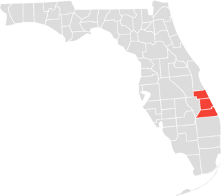
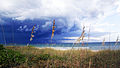
The Treasure Coast is a region in the southeast of the U.S. state of Florida. It borders the Atlantic Ocean and comprises Indian River, Martin, and St. Lucie Counties. The region, whose name refers to the Spanish Treasure Fleet that was lost in a 1715 hurricane, evidently emerged from residents' desire to distinguish themselves from the Gold Coast to the south.

<span class="mw-page-title-main">Indian River Lagoon</span> Three lagoons on the Atlantic Coast of Florida, United States

The Indian River Lagoon is a grouping of three lagoons: the Mosquito Lagoon, the Banana River, and the Indian River, on the Atlantic Coast of Florida; one of the most biodiverse estuaries in the Northern Hemisphere and is home to more than 4,300 species of plants and animals.

<span class="mw-page-title-main">St. Lucie Inlet, Florida</span> Ocean inlet in Florida, US

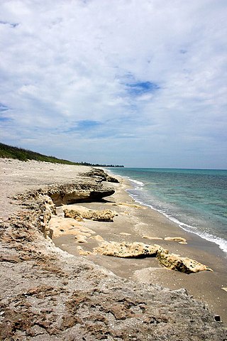
The St. Lucie Inlet, Florida is located between Hutchinson Island and Jupiter Island in Martin County, Florida, at coordinates 27°09′58″N80°09′24″W. The St. Lucie Inlet is one of six inlets into the Indian River Lagoon.

<span class="mw-page-title-main">County Road 707 (Treasure Coast)</span>

County Road 707 (CR 707) is a designation applied to two segments of road across three counties on Florida's Treasure Coast. The entire road was formerly designated State Road 707 (SR 707) and has been gradually transferred to county jurisdiction.

<span class="mw-page-title-main">Fort Pierce Inlet State Park</span> State park in Florida, United States

Fort Pierce Inlet State Park, a 340-acre (1.4 km2) part of the Florida State Park system, is located just north of the Fort Pierce Inlet, on North Hutchinson Island, near Fort Pierce. It consists of beaches, dunes and a coastal hammock between the Atlantic Ocean and the waters of Tucker Cove, an indentation of the Indian River Lagoon.

<span class="mw-page-title-main">Interstate 95 in Florida</span> Section of the Interstate 95 highway within the state of Florida

Interstate 95 (I-95) is the main Interstate Highway of Florida's Atlantic Coast. It begins at a partial interchange with US Highway 1 (US 1) just south of downtown Miami and heads north through Jacksonville, and to the Georgia state line at the St. Marys River near Becker. The route also passes through the cities of Fort Lauderdale, West Palm Beach, Port St. Lucie, Titusville, and Daytona Beach.

<span class="mw-page-title-main">Florida State Road 732</span>

State Road 732 (SR 732) comprises two segments of a state highway in the Jensen Beach, Florida vicinity. The western 2.2-mile-long (3.5 km) segment is a part of Jensen Beach Boulevard between U.S. Route 1 (US 1) and County Road 723 (CR 723) and CR 707A. The eastern 1.9-mile-long (3.1 km) segment consists of Causeway Boulevard and the Jensen Beach Causeway over the Indian River Lagoon and runs between CR 707 and SR A1A.

<span class="mw-page-title-main">U.S. Route 1 in Florida</span> Highway in Florida

U.S. Highway 1 (US 1) in Florida runs 545 miles (877 km) along the state's east coast from Key West to its crossing of the St. Marys River into Georgia north of Boulogne and south of Folkston. US 1 was designated through Florida when the U.S. Numbered Highway System was established in 1926. With the exception of Monroe County, the highway runs through the easternmost tier of counties in the state, connecting numerous towns and cities along its route, including nine county seats. The road is maintained by the Florida Department of Transportation (FDOT).

<span class="mw-page-title-main">St. Lucie River</span> River in the United States of America

The St. Lucie River is a 35-mile-long (56 km) estuary linked to a coastal river system in St. Lucie and Martin counties in the Florida, United States. The St. Lucie River and St. Lucie Estuary are an "ecological jewel" of the Treasure Coast, central to the health and well-being of the surrounding communities. The river is part of the larger Indian River Lagoon system, the most diverse estuarine environment in North America with more than 4,000 plant and animal species, including manatees, oysters, dolphins, sea turtles and seahorses.

<span class="mw-page-title-main">North Hutchinson Island</span>

North Hutchinson Island is a coastal barrier island in Indian River and St. Lucie counties on the east coast of Florida in the United States. The island is adjacent to the Atlantic Ocean and is separated from the mainland on the west by the Indian River Lagoon. The portion of the island in Indian River County is known as Orchid Island.

<span class="mw-page-title-main">Capt. Henry E. Sewall House</span> Building in Florida, United States

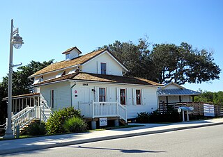
The Capt. Henry E. Sewall House is an historic wooden house now located in Indian RiverSide Park in Jensen Beach, in Martin County, Florida. Local pioneer and developer Capt. Henry E. Sewall built it in 1889 at the southern tip of Sewall's Point, the peninsula and town which bear his family name. When Capt. Sewall became the postmaster of Sewall's Point, the house served also as the Sewall's Point post office. Next to the house Capt. Sewall also built a freight dock that extended into the St. Lucie River along with a storage building at its end.

References

  1. "NOWData - NOAA Online Weather Data". National Oceanic and Atmospheric Administration . Retrieved May 24, 2021.
  2. "Summary of Monthly Normals 19912020". National Oceanic and Atmospheric Administration . Retrieved May 24, 2021.