Related Research Articles

Westmorland is a historic county in Northern England.

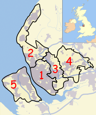
The Metropolitan Borough of Knowsley is a metropolitan borough in Merseyside, North West England. It covers several towns and villages, including Kirkby, Prescot, Huyton, Whiston, Halewood, Cronton and Stockbridge Village; Kirkby, Huyton, and Prescot being the major commercial centres. It takes its name from the village of Knowsley, though its headquarters are in Huyton. It forms part of the wider Liverpool City Region.

Huyton is a town in the Metropolitan Borough of Knowsley, Merseyside, England. Part of the Liverpool Urban Area, it borders the Liverpool suburbs of Dovecot, Knotty Ash and Belle Vale, and the neighbouring village of Roby, with which it formed Huyton with Roby Urban District between 1894 and 1974.

Roby is a village in the Metropolitan Borough of Knowsley, Merseyside, England. It was previously administratively linked with its neighbour Huyton by the Huyton-with-Roby civil parish and Huyton with Roby Urban District. Like Huyton, Roby is effectively a dormitory village or suburb of the neighbouring City of Liverpool. At the 2001 Census, the population of Roby was 9,353,. reducing to 7,254 at the 2011 Census. Roby is the location of the sixth form centre of Knowsley Community College.
A civil parish is a country subdivision, forming the lowest unit of local government in England. There are 22 civil parishes in the ceremonial county of Merseyside, most of the county being unparished; Liverpool and Wirral are completely unparished. At the 2001 census, there were 177,663 people living in the parishes, accounting for 13.0 per cent of the county's population.

Hazel Grove and Bramhall was a civil parish and urban district in north east Cheshire, England from 1900 to 1974.
Swinton and Pendlebury was a local government district of the administrative county of Lancashire, England. It was created in 1894 as an urban district and enlarged in 1934, gaining the status of a municipal borough.
Turton Urban District was, from 1873 to 1974, a local government district centred on the historical area of Turton in the administrative county of Lancashire, England.
Wigan Rural District was an administrative district in Lancashire, England from 1894 to 1974. The rural district comprised an area to the north, but did not include the town of Wigan.

Widnes was a county constituency in England, based on the town of Widnes, in Lancashire. It returned one Member of Parliament (MP) to the House of Commons of the Parliament of the United Kingdom, elected by the first past the post voting system.
Huyton was a former constituency for the House of Commons. Created in 1950, it was centred on Huyton in Lancashire, North West England, just beyond the borders of the city of Liverpool. The only MP was frontbench Labour politician, Harold Wilson who while representing the seat became Leader of the Labour Party in 1963 and prime minister from 1964 to 1970 and again from 1974 to 1976.
Denton Urban District was a local government district in England from 1894 to 1974.
Billinge was, from 1872 to 1974, a local government district in the administrative county of Lancashire, England.
The County Borough of Wigan was, from 1889 to 1974, a local government district centred on Wigan in the northwest of England. It was alternatively known as Wigan County Borough.

The Municipal Borough of Leigh was, from 1899 to 1974, a local government district of the administrative county of Lancashire, England, consisting of the townships of Pennington, Westleigh, Bedford and part of the township of Atherton and named after the ancient ecclesiastical parish. The area contained the market town of Leigh that served as its administrative centre until its dissolution in 1974. The borough council built Leigh Town Hall which was completed in 1907.
Prescot Urban District was a local government district in the administrative county of Lancashire, England from 1895 to 1974.the main settlement of the district was the town of Prescot.
Kirkby Urban District was a local government district in the administrative county of Lancashire, England, from 1958 to 1974. From 1949 onwards, the main settlement of the district was Kirkby new town. A District Council was created in 1958. The first meeting of the District Council was held on 9 April 1958. At that meeting it was resolved that Councillor James Wylie, J.P. be appointed Chairman of the Council

Mottram in Longdendale was one of the eight ancient parishes of the Macclesfield Hundred of Cheshire, England. Centred on St Michael and All Angels Church it included the townships of Godley, Hattersley, Hollingworth, Matley, Newton, Stayley, Tintwistle and Mottram itself. Under the Poor Law Amendment Act 1886 the townships became civil parishes in their own right.
Kearsley was, from 1865 to 1974, a local government district centred on the town of Kearsley in the administrative county of Lancashire, England.
Chorley Rural District was a rural district in the administrative county of Lancashire, England from 1894 to 1974.
References
- ↑ Vision of Britain Archived 2007-09-30 at the Wayback Machine - Huyton with Roby UD unit history
- ↑ Vision of Britain Archived 2007-10-01 at the Wayback Machine - Huyton with Roby parish boundaries
- ↑ Arnold-Baker, C., Local Government Act 1972, (1973)
53°24′43″N2°50′35″W / 53.412°N 2.843°W
| | This Merseyside location article is a stub. You can help Wikipedia by expanding it. |