Related Research Articles

A water turbine is a rotary machine that converts kinetic energy and potential energy of water into mechanical work.

A flood is an overflow of water that submerges land that is usually dry. In the sense of "flowing water", the word may also be applied to the inflow of the tide. Floods are an area of study of the discipline hydrology and are of significant concern in agriculture, civil engineering and public health. Human changes to the environment often increase the intensity and frequency of flooding, for example land use changes such as deforestation and removal of wetlands, changes in waterway course or flood controls such as with levees, and larger environmental issues such as climate change and sea level rise. In particular climate change's increased rainfall and extreme weather events increases the severity of other causes for flooding, resulting in more intense floods and increased flood risk.
A stream gauge, streamgage or stream gauging station is a location used by hydrologists or environmental scientists to monitor and test terrestrial bodies of water. Hydrometric measurements of water level surface elevation ("stage") and/or volumetric discharge (flow) are generally taken and observations of biota and water quality may also be made. The locations of gauging stations are often found on topographical maps. Some gauging stations are highly automated and may include telemetry capability transmitted to a central data logging facility.

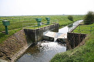
A weir or low-head dam is a barrier across the width of a river that alters the flow characteristics of water and usually results in a change in the height of the river level. Weirs are also used to control the flow of water for outlets of lakes, ponds, and reservoirs. There are many weir designs, but commonly water flows freely over the top of the weir crest before cascading down to a lower level. There is no single definition as to what constitutes a weir, and one English dictionary simply defines a weir as a small dam.
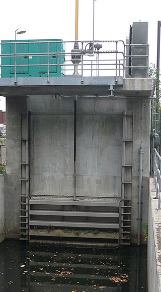
A sluice is a water channel containing a sluice gate, a type of lock to manage the water flow and water level. It can also be an open channel which processes material, such as a river sluice used in gold prospecting or fossicking. A mill race, leet, flume, penstock or lade is a sluice channeling water toward a water mill. The terms sluice, sluice gate, knife gate, and slide gate are used interchangeably in the water and wastewater control industry.
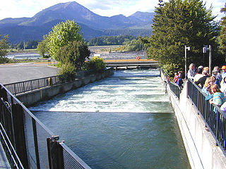
A fish ladder, also known as a fishway, fish pass, fish steps, or fish cannon is a structure on or around artificial and natural barriers to facilitate diadromous fishes' natural migration as well as movements of potamodromous species. Most fishways enable fish to pass around the barriers by swimming and leaping up a series of relatively low steps into the waters on the other side. The velocity of water falling over the steps has to be great enough to attract the fish to the ladder, but it cannot be so great that it washes fish back downstream or exhausts them to the point of inability to continue their journey upriver.

The Condamine River, part of the Balonne catchment that is part of the Murray-Darling Basin, drains the northern portion of the Darling Downs, an area of sub-coastal southern Queensland, Australia. The river is approximately 500 kilometers (310 mi) long and rises on Mount Superbus, South East Queensland's highest peak, on the western slopes of the Great Dividing Range, approximately 100 kilometres (62 mi) from the east coast of Queensland, and then flows north west across the Darling Downs, then west. The Condamine River is a tributary of the Darling River.

Hydraulic engineering as a sub-discipline of civil engineering is concerned with the flow and conveyance of fluids, principally water and sewage. One feature of these systems is the extensive use of gravity as the motive force to cause the movement of the fluids. This area of civil engineering is intimately related to the design of bridges, dams, channels, canals, and levees, and to both sanitary and environmental engineering.
A spillway is a structure used to provide the controlled release of water downstream from a dam or levee, typically into the riverbed of the dammed river itself. In the United Kingdom, they may be known as overflow channels. Spillways ensure that water does not damage parts of the structure not designed to convey water.
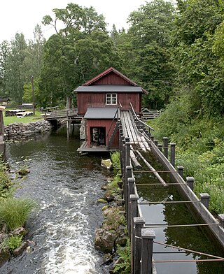
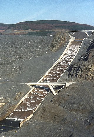
A flume is a human-made channel for water, in the form of an open declined gravity chute whose walls are raised above the surrounding terrain, in contrast to a trench or ditch. Flumes are not to be confused with aqueducts, which are built to transport water, rather than transporting materials using flowing water as a flume does. Flumes route water from a diversion dam or weir to a desired materiel collection location. Flumes are usually made up of wood, metal or concrete.

A culvert is a structure that channels water past an obstacle or to a subterranean waterway. Typically embedded so as to be surrounded by soil, a culvert may be made from a pipe, reinforced concrete or other material. In the United Kingdom, the word can also be used for a longer artificially buried watercourse.

Tailwater refers to waters located immediately downstream from a hydraulic structure, such as a dam, spillway, bridge or culvert. Generally measured and reported as the average water depth downstream of a hydraulic structure, tailwater can vary based on the outlet from the structure as well as downstream influences that may restrict or advance the usual flow of water from the structure. The creation of a tailwater will have significant impacts on both the abiotic and biotic conditions of the waterway.
The Manning formula or Manning's equation is an empirical formula estimating the average velocity of a liquid flowing in a conduit that does not completely enclose the liquid, i.e., open channel flow. However, this equation is also used for calculation of flow variables in case of flow in partially full conduits, as they also possess a free surface like that of open channel flow. All flow in so-called open channels is driven by gravity.
Hydraulics is a topic in engineering dealing with the mechanical properties of liquids.

The Parshall flume is an open channel flow metering device that was developed to measure the flow of surface waters and irrigation flows. The Parshall flume is a fixed hydraulic structure. It is used to measure volumetric flow rate in industrial discharges, municipal sewer lines, and influent/effluent flows in wastewater treatment plants. The Parshall flume accelerates flow through a contraction of both the parallel sidewalls and a drop in the floor at the flume throat. Under free-flow conditions the depth of water at specified location upstream of the flume throat can be converted to a rate of flow. Some states specify the use of Parshall flumes, by law, for certain situations.
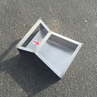
The Cutthroat flume is a class of flow measurement flume developed during 1966/1967 that is used to measure the flow of surface waters, sewage flows, and industrial discharges. Like other flumes, the Cutthroat flume is a fixed hydraulic structure. Using vertical sidewalls throughout, the flume accelerates flow through a contraction of sidewalls until the flow reaches the "throat" of the flume, where the flow is then expanded. Unlike the Parshall flume, the Cutthroat flume lacks a parallel-walled throat section and maintains a flat floor throughout the flume.

Packaged metering manholes (PMMs) are an outgrowth of the fiberglass manholes developed in the 1960s. Packaged metering manhole factories integrate a primary device (typically a flume or weir) into a fiberglass manhole.
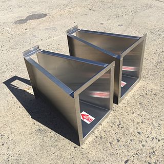
A Montana flume, is a popular modification of the standard Parshall flume. The Montana flume removes the throat and discharge sections of the Parshall flume, resulting a flume that is lighter in weight, shorter in length, and less costly to manufacture. Montana flumes are used to measure surface waters, irrigations flows, industrial discharges, and wastewater treatment plant flows.

The Palmer-Bowlus flume, is a class of flumes commonly used to measure the flow of wastewater in sewer pipes and conduits. The Palmer-Bowlus flume has a u-shaped cross-section and was designed to be inserted into, or in line with, pipes and u-channels found in sanitary sewer applications.

The Holyoke Testing Flume was a hydraulic testing laboratory and apparatus in Holyoke, Massachusetts, operated by the Holyoke Water Power Company from 1870 to 1932, and used to test the performance of water turbine designs, completing 3,176 tests of efficiency in that time. It was described by Robert E. Horton in court testimony as the only facility of its kind in the 19th and early 20th century, which made possible the standardization of American water turbines. Indeed Clemens Herschel, who managed and redesigned the facility in the 1880s, later described it in Congressional testimony as the "first modern hydraulic laboratory" in the United States and the world. It was through Herschel's need to determine the water power consumption of different mills, and in this testing system that he would invent the Venturi meter, the first accurate means of measuring large-scale flows, which still retains widespread use in modern technology today.
References
- ↑ Hydraulic structures United States Army Corps of Engineers Archived 2008-06-02 at the Wayback Machine
- ↑ "Hydraulic structure: flumes and weirs". Archived from the original on 2015-09-25. Retrieved 2013-03-10.
| | This hydrology article is a stub. You can help Wikipedia by expanding it. |