Status
The project was funded by the American Recovery and Reinvestment Act of 2009. In April 2008, the Corps awarded a construction contract to Shaw Environmental & Infrastructure for the Lake Borgne Surge Barrier, making this project the largest design-build civil works project in Corps history. It is highly unusual for a civil works project to be designed and constructed simultaneously. The expedited process was necessary, however, given the compressed time frame for achieving the 100-year level of risk reduction in 2011.
In October 2008, the New Orleans District Commander of the U.S. Army Corps of Engineers signed the Tier 2 portion of the Individual Environmental Report (IER), which investigated alternative alignments and designs within the location range identified by Tier 1 and explained the impacts of these alignments and footprints, construction materials and methods, and other design details. After the completion of the IER, a Notice to Proceed was issued to Shaw.
In December 2008, the Corps held a groundbreaking ceremony to mark the start of test pile driving. Construction of the barrier's flood wall began on 9 May 2009. On 21 October 2009 the last of the 1,271 main piles was driven. [3]
On 29 August 2012 (the seventh anniversary of Hurricane Katrina), the barrier was used for the first time, to protect the city from Hurricane Isaac. [4] By June 2013, all major construction had been completed. [1]

The Intracoastal Waterway (ICW) is a 3,000-mile (4,800 km) inland waterway along the Atlantic and Gulf of Mexico coasts of the United States, running from Massachusetts southward along the Atlantic Seaboard and around the southern tip of Florida, then following the Gulf Coast to Brownsville, Texas. Some sections of the waterway consist of natural inlets, saltwater rivers, bays, and sounds, while others are artificial canals. It provides a navigable route along its length without many of the hazards of travel on the open sea.

The Gulf Intracoastal Waterway (GIWW) is the portion of the Intracoastal Waterway located along the Gulf Coast of the United States. It is a navigable inland waterway running approximately 1,300 mi (2,100 km) from Saint Marks, Florida, to Brownsville, Texas.
The Mississippi River–Gulf Outlet Canal is a 76 mi (122 km) channel constructed by the United States Army Corps of Engineers at the direction of Congress in the mid-20th century that provided a shorter route between the Gulf of Mexico and New Orleans' inner harbor Industrial Canal via the Intracoastal Waterway. In 2005, the MRGO channeled Hurricane Katrina's storm surge into the heart of Greater New Orleans, contributing significantly to the subsequent multiple engineering failures experienced by the region's hurricane protection network. In the aftermath the channel was closed. A permanent storm surge barrier was constructed in the MRGO in 2009, and the channel has been closed to maritime shipping.
Bayou Bienvenue is a 12.1-mile-long (19.5 km) bayou and "ghost swamp" in southeastern Louisiana. It runs along the political border between Orleans Parish and St. Bernard Parish to the east of New Orleans. The Bayou Bienvenue Wetlands Triangle viewing platform in the Lower Ninth Ward provides expansive views of the bayou and also serves as an educational resource about restoration efforts in the area.

Lake Borgne is a lagoon of the Gulf of Mexico in southeastern Louisiana. Although early maps show it as a lake surrounded by land, coastal erosion has made it an arm of the Gulf of Mexico. Its name comes from the French word borgne, which means "one-eyed."

The Industrial Canal is a 5.5 mile (9 km) waterway in New Orleans, Louisiana, United States. The waterway's proper name, as used by the U.S. Army Corps of Engineers and on NOAA nautical charts, is Inner Harbor Navigation Canal (IHNC). The more common "Industrial Canal" name is used locally, both by commercial mariners and by landside residents.

Though Hurricane Katrina did not deal the city of New Orleans a direct hit on August 29, 2005, the associated storm surge precipitated catastrophic failures of the levees and flood walls. The Mississippi River Gulf Outlet ("MR-GO") breached its levees in approximately 15 places. The major levee breaches in the city include the 17th Street Canal levee, the London Avenue Canal, and the wide, navigable Industrial Canal, which left approximately 80% of the city flooded.
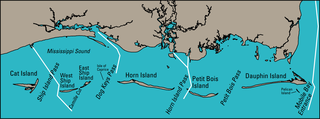
The Mississippi Sound is a sound along the Gulf Coast of the United States. It runs east-west along the southern coasts of Mississippi and Alabama, from Waveland, Mississippi, to the Dauphin Island Bridge, a distance of about 90 miles (145 km). The sound is separated from the Gulf on its southern side by the Mississippi–Alabama barrier islands: Cat, Ship, Horn, West Petit Bois, Petit Bois, and Dauphin. Ship, Horn, West Petit Bois and Petit Bois Islands are part of the National Park Service's Gulf Islands National Seashore. Those islands separate the sound from the Gulf of Mexico. The sediment of the islands was created partly by the ancient Mississippi River when the St. Bernard Lobe of the Mississippi Delta was active over two thousand years ago. The expansion of the St. Bernard subdelta slowly isolated the Mississippi Sound from ocean dynamics of the open Gulf of Mexico.
On Monday, August 29, 2005, there were over 50 failures of the levees and flood walls protecting New Orleans, Louisiana, and its suburbs following passage of Hurricane Katrina. The failures caused flooding in 80% of New Orleans and all of St. Bernard Parish. In New Orleans alone, 134,000 housing units — 70% of all occupied units — suffered damage from Hurricane Katrina and the subsequent flooding.

A flood barrier, surge barrier or storm surge barrier is a specific type of floodgate, designed to prevent a storm surge or spring tide from flooding the protected area behind the barrier. A surge barrier is almost always part of a larger flood protection system consisting of floodwalls, levees, and other constructions and natural geographical features.

The inland waterways of the United States include more than 25,000 mi (40,000 km) of navigable waters. Much of the commercially important waterways of the United States consist of the Mississippi River System—the Mississippi River and connecting waterways.

The Inner Harbor Navigation Canal Lock—commonly known as Industrial Canal Lock or simply Industrial Lock—is a navigation lock in New Orleans. It connects the Lower Mississippi River to the Industrial Canal and other sea-level waterways. Because it is shorter and narrower than most modern locks on the Mississippi River System, the 1920s vintage lock has become a bottleneck between the nation's two highest-tonnage waterways—the Mississippi and the Gulf Intracoastal Waterway.
The Morganza to the Gulf Hurricane Protection Project is a flood protection system for Terrebonne Parish and Lafourche Parish in the U.S. state of Louisiana. The targeted area is bounded on the west by Bayou Du Large and LA 311 and on the east by Bayou Lafourche. The U.S. Army Corps of Engineers is the federal sponsor for this project, and the Louisiana Department of Transportation and Development with the Terrebonne Levee and Conservation District jointly serve as the local sponsor. The Terrebonne Levee and Conservation District will provide operations and maintenance once the system is complete.
The Schooner Bayou Control Structure is a flood control structure located in Vermilion Parish, Louisiana, and operated by the U.S. Army Corps of Engineers. It is part of the Mississippi Valley Division, New Orleans District, which encompasses the southern half of the state of Louisiana.

The Gulf Intracoastal Waterway West Closure Complex is a part of the New Orleans Drainage System; it consists of a navigable floodgate, a pumping station, flood walls, sluice gates, foreshore protection, and an earthen levee. The complex was designed to reduce risk for residences and businesses in the project area from a storm surge associated with a tropical event, with an intensity that has a one percent chance of occurring in any given year. This project was operated for the first time on August 29, 2012, in response to Hurricane Isaac.

The Inner Harbor Navigation Canal (IHNC) Seabrook Floodgate Structure is a flood barrier in the Industrial Canal in New Orleans, Louisiana. The floodgate is designed to protect the Industrial Canal and the surrounding areas from a storm surge from Lake Pontchartrain. It consists of two 50-foot (15 m) wide vertical lift gates and a 95-foot (29 m) wide sector gate.

There are three outfall canals in New Orleans, Louisiana – the 17th Street, Orleans Avenue and London Avenue canals. These canals are a critical element of New Orleans’ flood control system, serving as drainage conduits for much of the city. There are 13 miles (21 km) of levees and floodwalls that line the sides of the canals. The 17th Street Canal is the largest and most important drainage canal and is capable of conveying more water than the Orleans Avenue and London Avenue Canals combined.

The greater New Orleans Hurricane & Storm Damage Risk Reduction System (HSDRRS) is an infrastructure systems in southern Louisiana which seeks to provide the greater New Orleans area a 100-year level of risk reduction, meaning reduced risk from a storm surge that has a 1% chance of occurring or being exceeded in any given year. In 2019, the Army Corps of Engineers announced that due to increased rate of sea level rise and continued sinking of soil the levee system would no longer offer original planned levels of protection as early as the year 2023.
The Jefferson Seaway was a proposed deep-draft ship channel to be created in Jefferson Parish, Louisiana, that would establish a route between the Mississippi River at Westwego and the Gulf of Mexico near Grand Isle. The Mississippi River provided the only deep-water access to New Orleans and its neighboring ports. In the mid-20th century, the creation of alternate routes was considered, including the Mississippi River-Gulf Outlet (MR-GO), which was ultimately selected, funded and constructed. The Jefferson Seaway, sometimes referred to as the Arrow to the Americas, the Mississippi Valley Seaway Canal, the Tidewater Ship Canal and the Barataria Canal, was also under consideration but ultimately was never constructed as a deep-draft channel.

