ITU Region

Last updated
ITU regions and the dividing lines between them.
.mw-parser-output .legend{page-break-inside:avoid;break-inside:avoid-column}.mw-parser-output .legend-color{display:inline-block;min-width:1.25em;height:1.25em;line-height:1.25;margin:1px 0;text-align:center;border:1px solid black;background-color:transparent;color:black}.mw-parser-output .legend-text{}
Region 1
Region 2
Region 3 International Telecommunication Union regions with dividing lines.svg
ITU regions and the dividing lines between them.
  Region 1
  Region 2
  Region 3

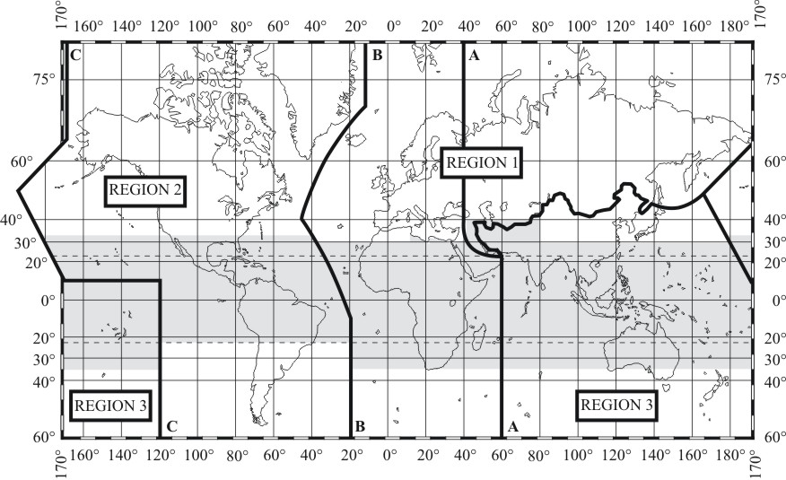
The International Telecommunication Union (ITU), in its International Radio Regulations, divides the world into three ITU regions for the purposes of managing the global radio spectrum. Each region has its own set of frequency allocations, the main reason for defining the regions.

Contents

Boundaries

Lines:

Usage

The definition of the European Broadcasting Area uses some of the definitions of Region 1.

ITU Zones

For convenience the regions are further divided into a total of 90 zones. While often following political boundaries, in more remote land and sea areas these are often defined to be roughly equal in size and so can have very low populations. As examples, Antarctica is divided into seven zones, and in one Pacific Ocean zone the only land area is tiny Minami Torishima. [2] For certain awards and contests amateur radio operators may attempt to contact as many zones as possible.

Related Research Articles

<span class="mw-page-title-main">Latitude</span> Geographic coordinate specifying north–south position

In geography, latitude is a coordinate that specifies the north–south position of a point on the surface of the Earth or another celestial body. Latitude is given as an angle that ranges from –90° at the south pole to 90° at the north pole, with 0° at the Equator. Lines of constant latitude, or parallels, run east–west as circles parallel to the equator. Latitude and longitude are used together as a coordinate pair to specify a location on the surface of the Earth.

<span class="mw-page-title-main">Sphere</span> Geometrical object that is the surface of a ball

A sphere is a geometrical object that is a three-dimensional analogue to a two-dimensional circle. A sphere is the set of points that are all at the same distance r from a given point in three-dimensional space. That given point is the centre of the sphere, and r is the sphere's radius. The earliest known mentions of spheres appear in the work of the ancient Greek mathematicians.

<span class="mw-page-title-main">Great circle</span> Spherical geometry analog of a straight line

In mathematics, a great circle or orthodrome is the circular intersection of a sphere and a plane passing through the sphere's center point.

<span class="mw-page-title-main">Map projection</span> Systematic representation of the surface of a sphere or ellipsoid onto a plane

In cartography, a map projection is any of a broad set of transformations employed to represent the curved two-dimensional surface of a globe on a plane. In a map projection, coordinates, often expressed as latitude and longitude, of locations from the surface of the globe are transformed to coordinates on a plane. Projection is a necessary step in creating a two-dimensional map and is one of the essential elements of cartography.

<span class="mw-page-title-main">Circle of latitude</span> Geographic notion

A circle of latitude or line of latitude on Earth is an abstract east–west small circle connecting all locations around Earth at a given latitude coordinate line.

<span class="mw-page-title-main">Adams–Onís Treaty</span> Treaty ceding Spanish Florida to the U.S. (1819)

The Adams–Onís Treaty of 1819, also known as the Transcontinental Treaty, the Spanish Cession, the Florida Purchase Treaty, or the Florida Treaty, was a treaty between the United States and Spain in 1819 that ceded Florida to the U.S. and defined the boundary between the U.S. and Mexico. It settled a standing border dispute between the two countries and was considered a triumph of American diplomacy. It came during the successful Latin American wars of independence against Spain.

<span class="mw-page-title-main">Eurovision Young Dancers</span> Biennial dance showcase

The Eurovision Young Dancers, often shortened to EYD, or Young Dancers, was a biennial dance competition, organised by the European Broadcasting Union (EBU) and is broadcast on television throughout Europe. Thirty-seven countries have taken part since the inauguration of the contest in 1985; including Kosovo and Canada.

<span class="mw-page-title-main">Time in the United States</span> U.S. time zones

Time in the United States, by law, is divided into nine standard time zones covering the states, territories and other US possessions, with most of the United States observing daylight saving time (DST) for approximately the spring, summer, and fall months. The time zone boundaries and DST observance are regulated by the Department of Transportation, but no single map of those existed until the agency announced intentions to make one in September 2022. Official and highly precise timekeeping services (clocks) are provided by two federal agencies: the National Institute of Standards and Technology (NIST) ; and the United States Naval Observatory (USNO). The clocks run by these services are kept synchronized with each other as well as with those of other international timekeeping organizations.

The 70-centimeter or 440 MHz band is a portion of the UHF radio spectrum internationally allocated to amateur radio and amateur satellite use. The ITU amateur radio allocation is from 430 to 440 MHz; however, some countries, such as the United States, allocate hams 420 to 450 MHz. Depending on the country the band is shared with other radio services.

The European–African–Middle Eastern Campaign Medal is a military award of the United States Armed Forces which was first created on November 6, 1942, by Executive Order 9265 issued by President Franklin D. Roosevelt. The medal was intended to recognize those military service members who had performed military duty in the European Theater during the years of the Second World War.

The American Campaign Medal is a military award of the United States Armed Forces which was first created on November 6, 1942, by Executive Order 9265 issued by President Franklin D. Roosevelt. The medal was intended to recognize those military members who had performed military service in the American Theater of Operations during World War II. A similar medal, known as the American Defense Service Medal was awarded for active duty service before the United States' entry into World War II.

Metes and bounds is a system or method of describing land, real property or real estate. The system has been used in England for many centuries and is still used there in the definition of general boundaries. The system is also used in the Canadian province of Ontario, and throughout Canada for the description of electoral districts. By custom, it was applied in the original Thirteen Colonies that became the United States and in many other land jurisdictions based on English common law, including Zimbabwe, South Africa, India and Bangladesh. While still in hand-me-down use, this system has been largely overtaken in the past few centuries by newer systems such as rectangular and lot and block.

<span class="mw-page-title-main">Triple junction</span> Meeting point of three tectonic plates

A triple junction is the point where the boundaries of three tectonic plates meet. At the triple junction each of the three boundaries will be one of three types – a ridge (R), trench (T) or transform fault (F) – and triple junctions can be described according to the types of plate margin that meet at them. Of the ten possible types of triple junction only a few are stable through time. The meeting of four or more plates is also theoretically possible but junctions will only exist instantaneously.

Fort William was a federal electoral district represented in the House of Commons of Canada from the year 1925 to 1979. It was located in the province of Ontario. This riding was created in 1924 from parts of Fort William and Rainy River riding.

<span class="mw-page-title-main">Eurovision Young Musicians</span>  TV series or program

The Eurovision Young Musicians, often shortened to EYM, or Young Musicians, is a biennial classical music competition for European musicians that are aged between 12 and 21. It is organised by the European Broadcasting Union (EBU) and broadcast on television throughout Europe, with some countries holding national selections to choose their representatives for the contest.

The meridian 115° west of Greenwich is a line of longitude that extends from the North Pole across the Arctic Ocean, North America, the Pacific Ocean, the Southern Ocean, and Antarctica to the South Pole.

<span class="mw-page-title-main">Equator</span> Imaginary line halfway between Earths North and South poles

The equator is a circle of latitude that divides a spheroid, such as Earth, into the northern and southern hemispheres. On Earth, it is an imaginary line located at 0 degrees latitude, about 40,075 km (24,901 mi) in circumference, halfway between the North and South poles. The term can also be used for any other celestial body that is roughly spherical.

This glossary of geography terms is a list of definitions of terms and concepts used in geography and related fields, including Earth science, oceanography, cartography, and human geography, as well as those describing spatial dimension, topographical features, natural resources, and the collection, analysis, and visualization of geographic data. Related terms may be found in glossary of geology, glossary of agriculture, glossary of environmental science, and glossary of astronomy.

<span class="mw-page-title-main">Borders of the oceans</span> Limits of Earths oceanic waters

The borders of the oceans are the limits of Earth's oceanic waters. The definition and number of oceans can vary depending on the adopted criteria. The principal divisions of the five oceans are the Pacific Ocean, Atlantic Ocean, Indian Ocean, Southern (Antarctic) Ocean, and Arctic Ocean. Smaller regions of the oceans are called seas, gulfs, bays, straits, and other terms. Geologically, an ocean is an area of oceanic crust covered by water.

<span class="mw-page-title-main">Radio communication service</span>

Radio communication service or radiocommunication service is according to Article 1.19 of the International Telecommunication Union's Radio Regulations, defined as “a service…involving the transmission, emission and/or reception of radio waves for specific telecommunication purposes”.

References

  1. "Radio Regulations". International Telecommunication Union. 2005-09-08. Retrieved 2006-07-18.
  2. Hammaps > ITU zones