Transport in Antarctica has transformed from explorers crossing the isolated remote area of Antarctica by foot to a more open era due to human technologies enabling more convenient and faster transport, predominantly by air and water, but also by land as well. Transportation technologies on a remote area like Antarctica need to be able to deal with extremely low temperatures and continuous winds to ensure the travelers' safety. Due to the fragility of the Antarctic environment, only a limited amount of transport movements can take place and sustainable transportation technologies have to be used to reduce the ecological footprint. The infrastructure of land, water and air transport needs to be safe and sustainable. Currently thousands of tourists and hundreds of scientists a year depend on the Antarctic transportation system.

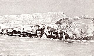
The Bay of Whales was a natural ice harbour, or iceport, indenting the front of the Ross Ice Shelf just north of Roosevelt Island, Antarctica, at the southernmost point of the world's ocean. While the Ross Sea stretches considerably further south – encompassing the Gould Coast, located around 320 kilometres from the South Pole – the majority of this expanse is covered by the Ross Ice Shelf, rather than open sea.

The Leverett Glacier is about 50 nautical miles (90 km) long and 3 to 4 nautical miles wide, flowing from the Antarctic Plateau to the south end of the Ross Ice Shelf through the Queen Maud Mountains. It is an important part of the South Pole Traverse from McMurdo Station to the Admundson–Scott South Pole Station, providing a route for tractors to climb from the ice shelf through the Transantarctic Mountains to the polar plateau.
The Amundsen Glacier is a major Antarctic glacier, about 7 to 11 km wide and 150 km (80 nmi) long. It originates on the Antarctic Plateau where it drains the area to the south and west of Nilsen Plateau, then descends through the Queen Maud Mountains to enter the Ross Ice Shelf just west of the MacDonald Nunataks.
The Herbert Range is a range in the Queen Maud Mountains of Antarctica, extending from the edge of the Antarctic Plateau to the Ross Ice Shelf between the Axel Heiberg Glacier and Strom Glacier. Named by the New Zealand Antarctic Place-Names Committee (NZ-APC) for Walter W. Herbert, leader of the Southern Party of the New Zealand GSAE (1961–62) which explored the Axel Heiberg Glacier area.
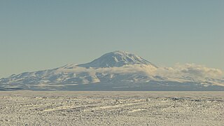
Mount Discovery is a conspicuous, isolated volcanic cone, 2,680 metres (8,790 ft) high, lying at the head of McMurdo Sound and east of Koettlitz Glacier, overlooking the northwest portion of the Ross Ice Shelf. It forms the center of a three-armed mass of which Brown Peninsula is one extension to the north; Minna Bluff is a second to the east; the third is Mount Morning to the west. Mount Discovery was discovered by the British National Antarctic Expedition (1901–04) and named for their expedition ship Discovery.

Koettlitz Glacier is a large Antarctic glacier lying west of Mount Morning and Mount Discovery in the Royal Society Range, flowing from the vicinity of Mount Cocks northeastward between Brown Peninsula and the mainland into the ice shelf of McMurdo Sound.
Kohler Range is a mountain range in Marie Byrd Land, Antarctica. The range is about 40 nautical miles long and stands between the base of Martin Peninsula and Smith Glacier. The range consists of two ice-covered plateaus punctuated by several rock peaks and bluffs. The plateaus are oriented East-West and are separated by the Kohler Glacier, a distributary which flows north from Smith Glacier.

The Usarp Mountains are a major mountain range in North Victoria Land, Antarctica. They are west of the Rennick Glacier and trend north to south for about 190 kilometres (118 mi). The mountains are bounded to the north by Pryor Glacier and the Wilson Hills. They are west of the Bowers Mountains.
The Norwegian–British–Swedish Antarctic Expedition (1949–1952) was the first Antarctica expedition involving an international team of scientists. The team members came from Norway, Sweden and the British Commonwealth of Nations.
Quarles Range is a high and rugged range of the Queen Maud Mountains, extending from the polar plateau between Cooper Glacier and Bowman Glacier and terminating near the edge of Ross Ice Shelf.

Atka Iceport, also known as Atka Bay, is an iceport about 10 miles (16 km) long and wide, marking a more-or-less permanent indentation in the front of the Ekstrom Ice Shelf on the coast of Queen Maud Land.
Quar Ice Shelf is the ice shelf between Cape Norvegia and Sorasen Ridge along the coast of Queen Maud Land.
The Hays Mountains are a large group of mountains and peaks of the Queen Maud Mountains of Antarctica, surmounting the divide between the lower portions of Amundsen Glacier and Scott Glacier and extending from the vicinity of Mount Thorne on the northwest to Mount Dietz on the southeast.
The Mulock Glacier is a large, heavily crevassed glacier which flows into the Ross Ice Shelf 40 kilometers south of the Skelton Glacier in the Ross Dependency, Antarctica.
Erskine Iceport, also known as Erskine Bay or General Erskine Bay, is an iceport about 3 nautical miles (6 km) wide and 6 nautical miles (11 km) long, which marks a more-or-less permanent indentation extending southeast into the seaward front of the extensive ice shelf fringing Queen Maud Land.
Norsel Iceport, also known as Norselbukta or Bukhta Nursel, is a small iceport in the front of the Quar Ice Shelf, along the coast of Queen Maud Land.
The Duncan Mountains are a group of rugged coastal foothills, about 18 nautical miles long, extending from the mouth of Liv Glacier to the mouth of Strom Glacier at the head of the Ross Ice Shelf in Antarctica.
The Medina Peaks are rugged, mainly ice-free, peaks surmounting a ridge 15 nautical miles long, extending north along the east side of Goodale Glacier to the edge of the Ross Ice Shelf, Antarctica.

