Ichma culture

Last updated
Ichma Kingdom
Ichma
1100–1469
Mapa cultura ichma.PNG
Domain of the Ichma or Ychsma people (in yellow)
Location Lima
Capital Pachacamac
Government Diarchy
History 
 Established
1100
 Disestablished
1469
Preceded by
Succeeded by
Map of Wari and Tiawaku.svg Wari Empire
Inca Empire Banner of the Inca Empire.svg

The Ichma kingdom (also written Ychma or Yschma, among other spellings) or Pachacamac kingdom [1] [2] was a pre-Inca indigenous polity later absorbed by the Inca Empire and reorganized as a wanami (province). For the Inca it was known as Pachakamaq (Pachacamac), rather than its original name of Ishma.

Contents

The Ishmay Kingdom was located south of Lima, Peru in the Lurín River valley; it later spread north into the Rímac River's valley. The Ishma culture was formed around 1100 AD following the breakup of the Wari Empire. Ishma autonomy lasted until around 1469 when they were absorbed into the Incan Empire. [3]

Despite occupying a desert, the inhabitants of Ishma had a high standard of living, thanks to their expertise in devising multiple irrigation channels as far as the river waters could reach, to give life to an extensive orchard and forest. [4]

Onomastics

At least since the Spanish conquest, the name used for the ancient temple as well as the nearby area is Pachacamac (from the Quechua name of deity). According to some colonial sources, though, the Pachachamac name might have been given by Inca conquerors, and the previous name for both the place and the temple was Ichma. [5]

This latter toponym has great variation in coloial sources, including <Ychma>, <Yzma>, <Ychsmac>, <Ychsma>, <Ychima>, <Ychmay> and <Irma>. [5] The word was clearly part of Classical Quechua vocabulary, as colonial dictionaries have it, written as <yxma> or <ychma>, as a color term for red. Contemporary linguists interpret additional evidence as pointing to cinnabar as the primary referent of the term. [6] [5] While colonial Quechua dictionaries point to [iʃma] or [itʃma] as Classical Quechua ponunciation for the color term, the <Irma> and <Ychsma> variants have been interpreted as evidence for a retroflex affricate sound, and for *[iʈʂma] as the original local pronunciation of the place name. [5]

Archaeologist Krysztof Makowski has proposed an Aymaran origin for Ichma, as an explanation for the existence of two placenames, as opposed to clearly Quechua Pachacamac. [7] This latter hypothesis has not been accepted by linguists.

Organization

The Ishma controlled coastal the valleys of Rimac and Lurin rivers in modern-day Lima, from the mouth—sea of the rivers to the middle valley or "Chaupi Yunga" (middle Yunga altitude, between 500 and 1200 meters of elevation). [8] [9] Ishma territory reached up to the sanctuary of Mama located in Rimac (present-day Ricardo Palma) and the sites of Chontay and Sisicaya in Lurin at 1,000 meters above sea level. [8] [10]

The Ishma were divided into two moiety administrative divisions or saya, these were the anan (upper) saya Ichma and luren (lower) saya Ichma. [11] On the coast, unlike the Andean highlands, the most important moiety often was that of luren (lurin) because it was linked to the sea. [4]

Each saya was in turn divided into unu or waranka subdivisions, which in turn were also divided into the anan and luren moieties, [12] The Ishma dominions of Lati, Surco (Sulco), Guatca, Rimac (Lima), and Maranga (Malanca) were located in the Rimac valley, while the dominions of Pachacamac (Ishma), Manchay, Quilcay (Quilcayuna), and Caringa were located in the Lurin valley. [8]

The city of Pachacamac, formerly known as Ishma before Inca conquest, was the capital of the Ishma kingdom and seat of its rulers. [13] Many Ishma ruins have been discovered along Lima's coast, however other than Pachacamac and a few other sites, there is no consensus on which the large majority sites could correspond to each domain, neither is known their physical distribution. [14] It has been proposed that the archaeological site of Pampa de Flores could be the head of Manchay dominion and residence of the Manchay ayllu (a subdivision of the waranka). [14]

History

Huaca San Borja Archaeological site Huaca San Borja Archaeological site - overview.jpg
Huaca San Borja Archaeological site

With the breakup of the Wari Empire, several small kingdoms and confederations were created. Over time, two cultures came to dominate the region, the Chancay culture to the north of Lima, and the Ishma culture to the south.

Is believed the Ishma people were an Aymara-speaking people that came to inhabit the coastal areas near Lima following the collapse of the Wari empire.

The Ishma people inhabited Pachacamac and continued the growth and influence of the city. The Ishma people constructed at least 16 pyramids in Pachacamac, and built or remodeled more structures in the Lima area. Among these are Huaca Huantille in the Magdalena del Mar district, Huaca Mateo Salado in Lima's district of Pueblo Libre, Huaca San Borja in the San Borja District, and Huaca Casa Rosada, Huaca Huantinamarca and Huaca San Miguel in the San Miguel District. Additionally, archeological sites in Puruchuco and Cajamarquilla have been ascribed to the Ichma people. [3]

Archaeology

A number of cultural and human remains have been discovered in various Ichma sites. In the Huaca Huantille, at least 9 mummies have been discovered, buried with ceramic items and jewelry crafted from copper, silver, and gold. [15] In 2012, excavation in the Pachacamac site yielded a burial chamber with more than 80 mummified remains, and a dozen infant remains. Along with the skeletons, this site also contained various artifacts, including ceramic wares, jewellery, and animal remains. [16]

As Luisa Diaz Arriola mentions: "The ethnohistorical narratives made by the Spaniards from 1533 AD, when they arrived in Pachacamac, are enriching but have a bias. They are what the informants wanted to tell, and reflect what the Spaniards of the 16th century considered important to record about those ancient inhabitants of Lima. The chronicles recorded religious beliefs, the importance of the deity Pachacamac and his kin, inter-valley relations, the existence of curacazgos, the coastal ecosystems, the irrigation schemes, among other aspects. But this information is insufficient to know all the dimensions of a past pre-colonial society. Archaeology has direct contact with the material remains left by the ychsma." [17]

Collapse of the Ichma

When the Inca Empire expanded into this region, the cultures of the Ichma and the Chancay people, along with smaller cultures, were absorbed into the Inca Empire.

See also

Related Research Articles

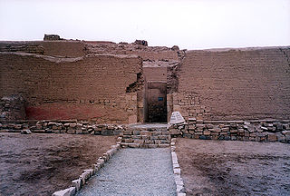
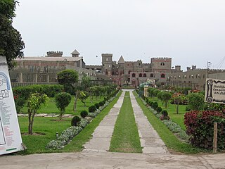
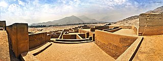
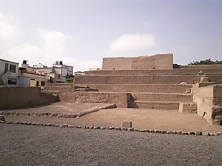
Pachacámac is an archaeological site 40 kilometres (25 mi) southeast of Lima, Peru in the Valley of the Lurín River. The site was first settled around A.D. 200 and was named after the "Earth Maker" creator god Pacha Kamaq. The site flourished for about 1,300 years until the Spanish invaded. Pachacamac covers about 600 hectares of land.

<span class="mw-page-title-main">Department of Lima</span> Departments of Peru

The Department of Lima, known as the Department of the Capital until 1823, is a department and region located in the central coast of Peru; the seat of the regional government is Huacho.

<span class="mw-page-title-main">Pacha Kamaq</span>

Pachacamac or Pacha Kamaq was the deity worshipped in the city of Pachacamac by the Ichma.

The Rímac River is located in western Peru and is the most important source of potable water for the Lima and Callao Metropolitan Area. It belongs to the Pacific Slope, into which it flows after bathing the cities of Lima and Callao, together with the Chillón River, to the north, and the Lurín River, to the south. It is 204 km long and has a basin of 3,312 km², of which 2,237.2 km² is a humid basin. The basin has a total of 191 lagoons, of which only 89 have been studied. The river begins in the highlands of the Huarochirí Province in the Lima Region and its mouth is located in Callao, near Jorge Chávez International Airport.

<span class="mw-page-title-main">Chinchay Suyu</span>

Chinchay Suyu or Chinchasuyu was the northwestern provincial region of the Tawantin Suyu, or Inca Empire. The most populous suyu, Chinchasuyu encompassed the former lands of the Chimú Empire and much of the northern Andes. At its largest extent, the suyu extended through much of modern Ecuador and just into modern Colombia. Along with Antisuyu, it was part of the Hanan Suyukuna or "Upper Quarters" of the empire.

<span class="mw-page-title-main">San Borja District</span> District in Lima, Peru

San Borja is a district of the Lima Province in Peru, and one of the upscale districts that comprise the city of Lima. Originally part of the district of Surquillo and San Isidro, it became officially established as a separate district on June 1, 1983. The new district took its name from a former hacienda (estate) which dominated the area. The district's postal code is 41. The current mayor (alcalde) is Marco Antonio Álvarez Vargas.

Peruvian art has its origin in the Andean civilizations. These civilizations rose in the territory of modern Peru before the arrival of the Spanish.

<span class="mw-page-title-main">El Brujo</span> Archaeological site in Peru

Located in the Chicama Valley, the El Brujo Archaeological Complex, just north of Trujillo, La Libertad Province, Peru, is an ancient archaeological site that was occupied from preceramic times. Considering the broad cultural sequencing, the Chicama Valley can be considered as an archaeological microcosm. Research at the site benefits from the favourable environmental and topological conditions for material conservation.

<span class="mw-page-title-main">Architecture of Peru</span>

Peruvian architecture is the architecture carried out during any time in what is now Peru, and by Peruvian architects worldwide. Its diversity and long history spans from ancient Peru, the Inca Empire, Colonial Peru to the present day.

<span class="mw-page-title-main">Chancay District, Huaral</span> District in Lima, Peru

Chancay District is one of twelve districts of the province Huaral in Peru.

<span class="mw-page-title-main">Lima culture</span>

The Lima culture was an indigenous civilization which existed in modern-day Lima, Peru during the Early Intermediate Period, extending from roughly 100 to 650. This pre-Incan culture, which overlaps with surrounding Paracas, Moche, and Nasca civilizations, was located in the desert coastal strip of Peru in the Chillon, Rimac and Lurin River valleys. It can be difficult to differentiate the Lima culture from surrounding cultures due to both its physical proximity to other, and better documented cultures, in Coastal Peru, and because it is chronologically very close, if not over lapped, by these other cultures as well. These factors all help contribute to the obscurity of the Lima culture, of which much information is still left to be learned.

<span class="mw-page-title-main">Viracochapampa</span> Archaeological site in Peru

Viracochapampa, Huiracochapampa, or Wiracochapampa is an archaeological site with the remains of a building complex of ancient Peru of pre-Inca times. It was one of the administrative centers of the Wari culture. Viracochapampa is located about 3.5 km north of Huamachuco in the region of La Libertad at an elevation of 3,070 metres (10,072 ft).

<span class="mw-page-title-main">Chancay culture</span>

The Chancay were a pre-Hispanic archeological civilization that developed between the valleys of Fortaleza, Pativilca, Supe, Huaura, Chancay, Chillón, Rimac and Lurín, on the central coast of Peru, from about 1000 to 1470 CE.

<span class="mw-page-title-main">National Museum of Peru</span> National museum in Lima, Peru

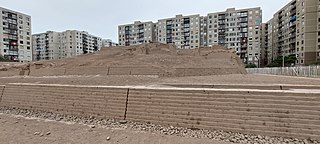
The National Museum of Peru is a national museum in Lurín District, Lima, Peru, located within the archaeological zone of Pachacamac. The museum will hold over a half million artifacts of the Pre-Columbian era and Inca Empire, ranging back to 5,000 BCE. It opened in July 2021 as part of Peru's bicentennial celebrations and is capable of accepting 15,000 guests per day.

<span class="mw-page-title-main">Battle of La Rinconada de Ate</span> 1881 battle of the War of the Pacific

The Battle of La Rinconada de Ate took place during the Lima campaign of the War of the Pacific. The battle occurred a few days before the Battle of San Juan and Chorrillos due to a surveying conflict.

<span class="mw-page-title-main">Huaca Huantinamarca</span> Archaeological site in Peru

The Huaca Huantinamarca is an archaeological site of the Ichma culture located in San Miguel District, in Lima, Peru. It is located on the first block of the Avenue Brígida Silva de Ochoa.

<span class="mw-page-title-main">Huaycán de Pariachi</span>

Huaycán de Pariachi is an archaeological site in Peru located in Huaycán, Ate District, Lima. south of the Rímac River. At different times, it was part of the Ichma culture and the Inca Empire.

<span class="mw-page-title-main">Huaca Santa Catalina</span> Archaeological site in Peru

Huaca Santa Catalina is an archaeological site located at Jirón Pascual Saco Oliveros 875, between Miguel Checa and Pascual Saco streets, in the neighbourhood of Santa Catalina, in La Victoria District, Lima, Peru. It's one of the few remains of the Qhapaq Ñan that exist in the city.

<span class="mw-page-title-main">Taulichusco</span> Incan Kuraka and final cacique of Lima

Taulichusco, also called the Elder, was an Incan kuraka who administered part of the Rímac Valley in the mid-16th century. The Stone of Taulichusco monument in his memory lies at the Pasaje Santa Rosa, next to the Plaza Mayor.

References

  1. Mora, César Gálvez; Rochietti, Ana (2018-03-20). Patrimonio cultural del Perú: Humanidad andina (in Spanish). Eduvim. ISBN   9789876992206.
  2. (Rostworowski, 1989: 71, 1992: 77)
  3. 1 2 "Lima History, the Chancay and Ichma Culture". www.limaeasy.com. Archived from the original on 2012-07-31. Retrieved 2012-05-25.
  4. 1 2 Soriano, Valdemar Espinoza (2014). "La etnia Ishma (Ychsma, Ichma, Ichmay)" [The ethnic Ishma (Ychsma, Ichma, Ichmay)]. Investigaciones Sociales (in Spanish). 18 (32): 117–159. doi: 10.15381/is.v18i32.10950 . ISSN   1818-4758.
  5. 1 2 3 4 Cerrón-Palomino, Rodolfo (2008). Voces del Ande: ensayos sobre onomástica andina. Colección estudios andinos (in Spanish) (1. ed.). Lima, Perú: Fondo Editorial de la Pontificia Universidad Católica del Perú. pp. 178–179. ISBN   978-9972-42-856-2.
  6. Torero, Alfredo (2005). Idiomas de los Andes: lingüística e historia. Filología, lingüística (2a ed.). Lima: Ed. Horizonte. pp. 139–140. ISBN   978-9972-699-38-2.
  7. Makowski, Krzysztof (March 2015). "Pachacamac—Old Wak'a or Inka Syncretic Deity?: Imperial Transformation of the Sacred Landscape in the Lower Ychsma (Lurín) Valley". The Archaeology of Wak'as: Explorations of the Sacred in the Pre-Columbian Andes: 127–166.
  8. 1 2 3 Salazar, Casas; Lizbeth, Lyda (2017). "La zona de Carapongo como expresión física de una entidad política, durante el período de los Reinos y Señoríos Tardíos". Universidad Nacional Mayor de San Marcos. Archived from the original on 2019-10-26. Retrieved 2019-09-17.
  9. Román Godines, Oscar (2013). "El paisaje de Nieve Nieve: la chaupi yunga del Lurín". Ministerio de Cultura.
  10. (Rostworowski, 1976, 1989; Espinoza, 1963, 1964, 1983).
  11. Vallejo, Francisco; Díaz, Luisa (2002-04-09). "Armatambo y el dominio incaico en el valle de Lima". Boletín de Arqueología PUCP (6): 355–374. doi: 10.18800/boletindearqueologiapucp.200201.014 . ISSN   2304-4292.
  12. Makowski, Krzysztof (2002-04-09). "Arquitectura, estilo e identidad en el Horizonte Tardío: el sitio de Pueblo Viejo-Pucará, valle de Lurín". Boletín de Arqueología PUCP (6): 137–170. doi: 10.18800/boletindearqueologiapucp.200201.007 . ISSN   2304-4292. The site, located between 400 and 600 meters above sea level in a loma ecozone on the left bank of the river, could have been the main habitation center of the Caringa of Huarochiri, one of the Caringa moieties of the unu of Luren.
  13. Díaz, Luisa; Vallejo, Francisco (2004). "VARIACIONES CULTURALES EN EL VALLE DE LIMA DURANTE LA OCUPACIÓN INCAICA / CULTURAL VARIATIONS IN LIMA VALLEY DURING THE INKA PERIOD". Chungara: Revista de Antropología Chilena. 36 (2): 295–302. ISSN   0716-1182. JSTOR   27802272.
  14. 1 2 Marcone Flores, Giancarlo (2004-12-01). "Cieneguilla a la llegada de los Incas Aproximaciones desde la historia ecológica y la arqueológica". Bulletin de l'Institut français d'études andines (in Spanish). 33 (3): 715–734. doi: 10.4000/bifea.5330 . ISSN   0303-7495.
  15. "Pre-Incan Mummies found in Lima". infosurhoy.com. Archived from the original on 2013-01-26. Retrieved 2012-05-25.
  16. "Temple of Doom: Scientists Discover peruvian Tomb Filled with Mummies, Infants". time.com. 2012-05-24. Retrieved 2012-05-25.
  17. Díaz Arriola, Luisa (2022). Los ychsma. Habitantes prehispánicos de Lima (PDF) (in Spanish). Municipalidad de Lima.