Related Research Articles

Topography is the study of the forms and features of land surfaces. The topography of an area may refer to the land forms and features themselves, or a description or depiction in maps.
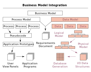
A data model is an abstract model that organizes elements of data and standardizes how they relate to one another and to the properties of real-world entities. For instance, a data model may specify that the data element representing a car be composed of a number of other elements which, in turn, represent the color and size of the car and define its owner.

The Geography Markup Language (GML) is the XML grammar defined by the Open Geospatial Consortium (OGC) to express geographical features. GML serves as a modeling language for geographic systems as well as an open interchange format for geographic transactions on the Internet. Key to GML's utility is its ability to integrate all forms of geographic information, including not only conventional "vector" or discrete objects, but coverages and sensor data.
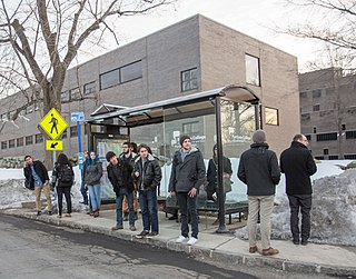
A bus stop is a place where buses stop for passengers to get on and off the bus. The construction of bus stops tends to reflect the level of usage, where stops at busy locations may have shelters, seating, and possibly electronic passenger information systems; less busy stops may use a simple pole and flag to mark the location. Bus stops are, in some locations, clustered together into transport hubs allowing interchange between routes from nearby stops and with other public transport modes to maximise convenience.
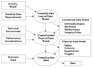
Data modeling in software engineering is the process of creating a data model for an information system by applying certain formal techniques. It may be applied as part of broader Model-driven engineering (MDE) concept.

Downtown Crossing station is an underground Massachusetts Bay Transportation Authority (MBTA) rapid transit station located in the Downtown Crossing retail district in the downtown core of Boston, Massachusetts. It is served by the Orange Line and Red Line, and is one of four "hub stations" on the MBTA subway system. Downtown Crossing is also a major bus transfer location serving 13 MBTA bus routes, including one Silver Line route. It is the second busiest subway station in the MBTA network, with an average of 24,074 entries per weekday in FY2019.

Intermodal passenger transport, also called mixed-mode commuting, involves using two or more modes of transportation in a journey. Mixed-mode commuting is often used to combine the strengths of various transportation options. A major goal of modern intermodal passenger transport is to reduce dependence on the automobile as the major mode of ground transportation and increase use of public transport. To assist the traveller, various intermodal journey planners such as Rome2rio and Google Transit have been devised to help travellers plan and schedule their journey.

The National Public Transport Access Node (NaPTAN) database is a UK nationwide system for uniquely identifying all the points of access to public transport in the UK. The dataset is closely associated with the National Public Transport Gazetteer.
The public transport accessibility level (PTAL) is a method sometimes used in United Kingdom transport planning to assess the access level of geographical areas to public transport.

The Transport Direct Programme was a division of the UK Department for Transport (DfT) to develop standards, data and better information technology systems to support public transport. It developed and operates the Transport Direct Portal which is a public facing multi-modal journey planner. It also supports the creation and management of comprehensive databases of all public transport movements in the United Kingdom with Traveline. During 2010 two key datasets were released as Open Data and published on www.data.gov.uk.

Carriedo station is an elevated Light Rail Transit (LRT) station located on the LRT Line 1 (LRT-1) system along the district boundary of Santa Cruz and Quiapo in Manila.
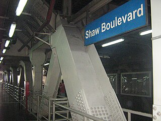
Shaw Boulevard station is an elevated Metro Rail Transit (MRT) station located on the MRT Line 3 (MRT-3) system in the Mandaluyong portion of Ortigas Center. The station is named after Shaw Boulevard, since the station lies directly above the boulevard. Being at the center of the whole line, many commuters regard Shaw Boulevard station as the "central terminal" of the line.

Kwinana railway station is a railway station in Bertram and Parmelia, suburbs of Perth, Western Australia. It is on the Mandurah railway line, which is part of the Transperth commuter rail network, and it serves the City of Kwinana. It has two side platforms located in a cutting, accessed by a ground-level station concourse. Services run every 10 minutes during peak, and every 15 minutes between peak. The journey to Perth railway station is 32.9 kilometres (20.4 mi), and takes 26 minutes. The station has a bus interchange with five bus stands, and five regular bus routes.

A passenger information system, or passenger information display system, is an automated system for supplying users of public transport with information about the nature and the state of a public transport service through visual, voice or other media. It is also known as a customer information system or an operational information system. Among the information provided by such systems, a distinction can be drawn between:
TransXChange is a UK national XML based data standard for the interchange of bus route and timetable information between bus operators, the Vehicle and Operator Services Agency, local authorities and passenger transport executives, and others involved in the provision of passenger information.
The Standard Interface for Real-time Information or SIRI is an XML protocol to allow distributed computers to exchange real-time information about public transport services and vehicles.
Transmodel, also known as Reference Data Model For Public Transport , is a European Standard for modelling and exchanging public transport information. It provides a standard data model and specialised data structures to uniformly represent common public transport concepts, facilitating the use of data in a wide variety of public transport information systems, including for timetabling, fares, operational management, real-time data, and journey planning.
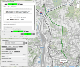
A journey planner, trip planner, or route planner is a specialized search engine used to find an optimal means of travelling between two or more given locations, sometimes using more than one transport mode. Searches may be optimized on different criteria, for example fastest, shortest, fewest changes, cheapest. They may be constrained, for example, to leave or arrive at a certain time, to avoid certain waypoints, etc. A single journey may use a sequence of several modes of transport, meaning the system may know about public transport services as well as transport networks for private transportation. Trip planning or journey planning is sometimes distinguished from route planning, which is typically thought of as using private modes of transportation such as cycling, driving, or walking, normally using a single mode at a time. Trip or journey planning, in contrast, would make use of at least one public transport mode which operates according to published schedules; given that public transport services only depart at specific times, an algorithm must therefore not only find a path to a destination, but seek to optimize it so as to minimize the waiting time incurred for each leg. In European Standards such as Transmodel, trip planning is used specifically to describe the planning of a route for a passenger, to avoid confusion with the completely separate process of planning the operational journeys to be made by public transport vehicles on which such trips are made.

A view model or viewpoints framework in systems engineering, software engineering, and enterprise engineering is a framework which defines a coherent set of views to be used in the construction of a system architecture, software architecture, or enterprise architecture. A view is a representation of the whole system from the perspective of a related set of concerns.
NeTEx is the CEN Technical standard for exchanging Public Transport Information as XML documents. It provides a W3C XML schema based on the Transmodel abstract model of common public transport concepts and data structures and can be used to exchange many different kinds of data between passenger information systems, including data describing for stops, facilities, timetabling and fares. Such data can be used by both operational management systems and customer facing systems for journey planning etc.
References
- ↑ Transmodel. "Identification of Fixed Objects in Public Transport (Transmodel)". transmodel-cen.eu. Retrieved 2024-03-09.
prCEN Technical Specification Identification of Fixed Objects In Public Transport.