
Baffin Island, in the Canadian territory of Nunavut, is the largest island in Canada and the fifth-largest island in the world. Its area is 507,451 km2 (195,928 sq mi), slightly larger than Spain; its population was 13,039 as of the 2021 Canadian census; and it is located at 68°N70°W. It also contains the city of Iqaluit, the capital of Nunavut.

Victoria Island is a large island in the Arctic Archipelago that straddles the boundary between Nunavut and the Northwest Territories of Canada. It is the eighth-largest island in the world, and at 217,291 km2 (83,897 sq mi) in area, it is Canada's second-largest island. It is nearly double the size of Newfoundland (111,390 km2 [43,010 sq mi]), and is slightly larger than the island of Great Britain (209,331 km2 [80,823 sq mi]) but smaller than Honshu (225,800 km2 [87,200 sq mi]). The western third of the island lies in the Inuvik Region of the Northwest Territories; the remainder is part of Nunavut's Kitikmeot Region. The population of 2,168 is divided among 2 settlements, the larger of which is in Nunavut and the other of which is in the Northwest Territories.
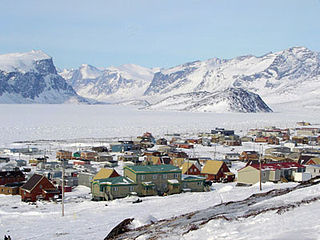
Pangnirtung is an Inuit hamlet, in the Qikiqtaaluk Region of the Canadian territory of Nunavut, located on Baffin Island. The community is located about 45 km (28 mi) south of the Arctic Circle, and about 2,700 km (1,700 mi) from the North Pole. Pangnirtung is situated on a coastal plain at the coast of Pangnirtung Fjord, a fjord which eventually merges with Cumberland Sound. As of January 2022, the mayor is Stevie Komoartok.

Mansel Island, a member of the Arctic Archipelago, is an uninhabited island in Qikiqtaaluk Region, Nunavut. It is located in Hudson Bay off of Quebec's Ungava Peninsula. At 3,180 km2 (1,230 sq mi) in size, it is the 159th largest island in the world, and Canada's 28th largest island.

Devon Island is an island in Canada and the largest uninhabited island in the world. It is located in Baffin Bay, Qikiqtaaluk Region, Nunavut, Canada. It is one of the largest members of the Arctic Archipelago, the second-largest of the Queen Elizabeth Islands, Canada's sixth-largest island, and the 27th-largest island in the world. It has an area of 55,247 km2 (21,331 sq mi). The bedrock is Precambrian gneiss and Paleozoic siltstones and shales. The highest point is the Devon Ice Cap at 1,920 m (6,300 ft) which is part of the Arctic Cordillera. Devon Island contains several small mountain ranges, such as the Treuter Mountains, Haddington Range and the Cunningham Mountains. The notable similarity of its surface to that of Mars has attracted interest from scientists.

Nagjuttuuq, formerly Vansittart Island, is one of the uninhabited Canadian arctic islands in the Kivalliq Region, Nunavut, Canada. It is located in Foxe Basin, north of Southampton Island, and has an area of 997 km2 (385 sq mi).

The locality Port Leopold is an abandoned trading post in the Qikiqtaaluk Region of Nunavut, Canada. It faces Prince Regent Inlet at the northeast tip of Somerset Island.
Innetalling Island is an uninhabited island in Qikiqtaaluk Region, Nunavut, Canada. Located in Hudson Bay's Omarolluk Sound, it is a member of the Belcher Islands group. It runs from Fairweather Sound at its northern end to Ridge Passage at its southern one. Fairweather Harbour is located on the north end of the island's east side.
Wager Bay or Ukkusiksalik Bay is long narrow inlet in the Kivalliq Region of Nunavut, Canada, which opens east into Roes Welcome Sound at the northwest end of Hudson Bay. Ukkusiksalik National Park surrounds it.

Kangiqtugaapik formerly Clyde Inlet is a body of water in eastern Baffin Island, Qikiqtaaluk Region, Nunavut. Its mouth opens into the Davis Strait from the west.
Denmark Bay is an Arctic waterway in Kitikmeot Region, Nunavut, Canada. It is located in western M'Clintock Channel, off the eastern coast of Victoria Island. It is separated from Homan Bay by a peninsula with a narrow isthmus.
Sutton Island is located in northern Canada's territory of Nunavut. It is situated in the Dolphin and Union Strait immediately next to Liston Island. Rymer Point and Simpson Bay, on Victoria Island's Wollaston Peninsula are to the northeast. Bernard Harbour, on the mainland, is to the southwest, as is Chantrey Island.
Stupart Island is one of the uninhabited Canadian arctic islands in Nunavut, Canada. It lies in the Arctic Ocean, south-east of Lougheed Island and west of Edmund Walker Island. It is part of the Findlay Group.

Aggijjat formerly Durban Island is a Canadian Arctic island located in Nunavut, Canada. It is one of Baffin Island's northeast offshore islands within Davis Strait's Merchants Bay. It is 36 km2 (14 sq mi) in size. Durban Harbour is on the island's southeast facing side. Nearby can be found the larger Paallavvik, and Auyuittuq National Park is also to the west on Baffin Island.
The Croker River is a waterway above the Arctic Circle on the mainland of Northern Canada in the western Kitikmeot Region, Nunavut. It is the largest river between Darnley Bay and Coronation Gulf that flows into Amundsen Gulf. The Croker averages 55 m (180 ft) in width.
The Gretha Islands are an uninhabited island group located in the Qikiqtaaluk Region of Nunavut, Canada. They are situated in Eureka Sound at the confluence of Bay Fjord, north of Ellesmere Island's Raanes Peninsula, and east of Stor Island. They are members of the Sverdrup Islands group, Queen Elizabeth Islands, and the Arctic Archipelago.
Killiniq is a former Inuit settlement, weather station, trading post, missionary post, fishing station, and Royal Canadian Mounted Police post on Killiniq Island. Previously within Labrador, and then the Northwest Territories, it is now situated within the borders of Nunavut. The community closed in 1978.

Dundas Harbour is an abandoned settlement in the Qikiqtaaluk Region, Nunavut, Canada. It is located on Devon Island at the eastern shore of the waterway also named Dundas Harbour. Baffin Bay's Croker Bay is immediately to the west.

Port Burwell is a harbour on western Killiniq Island, formed as an arm of Ungava Bay, at the mouth of Hudson Strait. Previously within Labrador, and then the Northwest Territories, it is now situated within the borders of Nunavut, Canada. Cape Chidley is 25 miles (40 km) to the northeast. The community of Port Burwell lies on the shore at 60°25′30″N64°50′00″W.
Bernard Harbour is a bay on the mainland of Nunavut, Canada. It is situated on Dolphin and Union Strait, southwest of Sutton Island.

