The Geography of Kenya is diverse, varying amongst its 47 counties. Kenya has a coastline on the Indian Ocean, which contains swamps of East African mangroves. Inland are broad plains and numerous hills. Kenya borders South Sudan to the northwest, Uganda to the west, Somalia to the east, Tanzania to the south, and Ethiopia to the north.

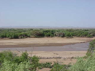
The Kerio River is a river in Turkana County, Kenya. It flows northward into Lake Turkana. It is one of the longest rivers in Kenya, originating near the equator.

Richard Erskine Frere Leakey was a Kenyan paleoanthropologist, conservationist and politician. Leakey held a number of official positions in Kenya, mostly in institutions of archaeology and wildlife conservation. He was Director of the National Museum of Kenya, founded the NGO WildlifeDirect, and was the chairman of the Kenya Wildlife Service.

Lake Turkana, formerly known as Lake Rudolf, is a lake in the Kenyan Rift Valley, in northern Kenya, with its far northern end crossing into Ethiopia. It is the world's largest permanent desert lake and the world's largest alkaline lake. By volume it is the world's fourth-largest salt lake after the Caspian Sea, Issyk-Kul, and Lake Van, and among all lakes it ranks 24th.

The Goldman Environmental Prize is a prize awarded annually to grassroots environmental activists, one from each of the world's six geographic regions: Africa, Asia, Europe, Islands and Island Nations, North America, and South and Central America. The award is given by the Goldman Environmental Foundation headquartered in San Francisco, California. It is also called the Green Nobel.

Meave G. Leakey is a British palaeoanthropologist. She works at Stony Brook University and is co-ordinator of Plio-Pleistocene research at the Turkana Basin Institute. She studies early hominid evolution and has done extensive field research in the Turkana Basin. She has Doctor of Philosophy and Doctor of Science degrees.

The Turkana are a Nilotic people native to the Turkana County in northwest Kenya, a semi-arid climate region bordering Lake Turkana in the east, Pokot, Rendille and Samburu people to the south, Uganda to the west, and South Sudan and Ethiopia to the north.
Lake Logipi is a saline, alkaline lake that lies at the northern end of the arid Suguta Valley in the northern Kenya Rift. It is separated from Lake Turkana by the Barrier volcanic complex, a group of young volcanoes that last erupted during the late 19th century or early 20th century. Saline hot springs discharge on the northern shoreline of Lake Logipi and at Cathedral Rocks near its southern limit, and help to maintain water at times of extreme aridity. During the rainy season, the lake is also recharged from the Suguta River which flows northward along the Suguta Valley, periodically forming a temporary lake that unites with Logipi.

Sibiloi National Park lies on the northeastern shore of Lake Turkana in northern Kenya. Established in 1973 by the government of Kenya for the protection of wildlife and paleontologist sites there, it covers 1,570 km2 (610 sq mi) and is internationally known for its fossils. It was listed as a UNESCO World Heritage Site in 1997 as a part of Lake Turkana National Parks.

The Turkwel River is a river flowing from Mount Elgon on the border of Kenya and Uganda to Lake Turkana. The river is called the Suam River from its source to the border at Turkana County of Kenya. The name Turkwel is derived from the Turkana name for the river, Tir-kol, which means a river that "withstands the wilderness". The Turkwel begins on the lush green slopes of Mount Elgon and the Cherangani Hills, then traverses the Southern Turkana Plains, crosses the Loturerei Desert near Lodwar and empties into the world's largest desert lake, Lake Turkana. The river's flow is seasonally varied, and it is subject to flash floods in the rainy season.

Turkana County is a county in the former Rift Valley Province of Kenya. It is Kenya's largest county by land area, and also its northwesternmost. It is bordered by the countries of Uganda to the west; South Sudan and Ethiopia, including the disputed Ilemi Triangle, to the north and northeast; and Lake Turkana to the east. To the south and east, neighbouring counties in Kenya are West Pokot, Baringo and Samburu Counties, while Marsabit County is on the opposite shore of Lake Turkana. Turkana's capital and largest town is Lodwar. The county had a population of 926,976 at the 2019 census.

The Gilgel Gibe III Dam is a 250m high roller-compacted concrete dam with an associated hydroelectric power plant on the Omo River in Ethiopia. It is located about 62 km (39 mi) west of Sodo in the Southern Nations, Nationalities, and Peoples' Region. Once fully commissioned, it will be the third largest hydroelectric plant in Africa with a power output of about 1870 Megawatt (MW), thus more than doubling total installed capacity in Ethiopia from its 2007 level of 814 MW. The Gibe III dam is part of the Gibe cascade, a series of dams including the existing Gibe I dam and Gibe II power station as well as the planned Gibe IV and Gibe V dams. The existing dams are owned and operated by the state-owned Ethiopian Electric Power, which is also the client for the Gibe III Dam.

Lothagam is a geological formation located in Kenya, near the southwestern shores of Lake Turkana, 55 km (34 mi) from Kanapoi. It is located between the Kerio and Lomunyenkuparet Rivers on an uplifted fault block. Lothagam has deposits dating to the Miocene-Pliocene period and numerous palaeontological finds have been recovered here. Archaeological sites dating to the Holocene are also found at Lothagam, including the Lothagam Lokam harpoon site and the Lothagam North Pillar Site.

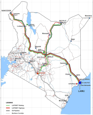
Lamu Port-South Sudan-Ethiopia-Transport (LAPSSET) Corridor project, also known as Lamu corridor is a transport and infrastructure project in Kenya that, when complete, will be the country's second transport corridor. Kenya's other transport corridor is the Mombasa - Uganda transport corridor that passes through Nairobi and much of the Northern Rift. Some basic LAPSSET infrastructure has been built. The construction of LAPSSET's main components is currently ongoing with construction of the first berth at Lamu Port completed in October, 2019 (situation as per October 2019).. Although the project is not formally stalled, its short to medium term success looks increasingly unlikely. Insecurity and political instability in Kenya are mostly to blame for this, as are more commercially viable alternative pipeline options through Tanzania or Ethiopia. The low oil prices since 2015 also affect LAPSSET's commercial prospects.

The greater Turkana Basin in East Africa determines a large endorheic basin, a drainage basin with no outflow centered around the north-southwards directed Gregory Rift system in Kenya and southern Ethiopia. The deepest point of the basin is the endorheic Lake Turkana, a brackish soda lake with a very high ecological productivity in the Gregory Rift.

Lake Turkana Wind Power Project (LTWP) is a wind farm in Kenya. It is located in Loiyangalani District, in Marsabit County, approximately 545 kilometres (339 mi) by road north of Nairobi, Kenya's capital city. The wind farm covers 160 square kilometres and has a capacity of 310 MW, enough to supply one million homes. It comprises 365 wind turbines, each with a capacity of 850 kilowatts. The associated overhead electric grid distribution system and a high voltage substation that connect it to the national grid.
Despite its high potential for wind energy generation, wind power in Kenya currently contributes only about 16 percent of the country's total electrical power. However, its share in energy production is increasing. Kenya Vision 2030 aims to generate 2,036 MW of wind power by 2030. To accomplish this goal, Kenya is developing numerous wind power generation centers and continues to rely on the nation's three major wind farms: the Lake Turkana Wind Power Station, the Kipeto Wind Power Station, and the Ngong Hills Wind Farm. While these wind power stations are beneficial to help offset fossil fuel usage and increase overall energy supply reliability in Kenya, project developments have also negatively impacted some indigenous communities and the parts of the environment surrounding the wind farms.
Sonia Harmand is a French archaeologist who studies Early Stone Age archaeology and the evolution of stone tool making. She received her undergraduate degree from the University of Paris where she was associated with the "Prehistory and Technology" research unit, which was well known in the field of stone tool analysis. Harmand earned a PhD from Paris Nanterre University, and is a research associate at CNRS, which is the largest French governmental research organization, and Europe's largest fundamental science agency. She worked as a Research Scientist at CNRS for four years before joining Stony Brook University in New York as an associate professor. In 2017 she was named one of the '50 Most Influential French' by the French edition of Vanity Fair magazine.
Friends of Lake Turkana (FoLT) is a nonprofit organization in Kenya that was founded in 2007 by Kenyan environmentalist Ikal Angelei. The organization has worked to stop the construction of the Ethiopian Gilgel Gibe III Dam on the Omo River, Lake Turkana's primary source of water. Due to FoLT and other partner's advocacy work on saving Lake Turkana, the Lake was added to the list of world Heritage sites in Danger by UNESSCO in June 2018.

The Lothagam North Pillar Site, registered as GeJi9, is an archaeological site on the west side of Lake Turkana in Kenya dating to the Pastoral Neolithic and the Holocene. It is a communal cemetery, built between 3000 BCE and 2300 BCE by the region's earliest herders as rainfall in the area decreased and Lake Turkana receded. It is thought to be eastern Africa's largest and earliest monumental cemetery.


