Related Research Articles

Macquarie Pass National Park is a national park in New South Wales, Australia, 90 km southwest of Sydney. It is located around the pass of the same name, which is on the Illawarra Highway and part of the Illawarra escarpment.

An escarpment is a steep slope or long cliff that forms as a result of faulting or erosion and separates two relatively level areas having different elevations. Usually scarp and scarp face are used interchangeably with escarpment.
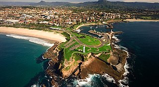
Wollongong, informally referred to as "The Gong", is a city located in the Illawarra region of New South Wales, Australia. Wollongong lies on the narrow coastal strip between the Illawarra Escarpment and the Pacific Ocean, 68 kilometres south of central Sydney. Wollongong had an estimated urban population of 302,739 at June 2018, making it the third-largest city in New South Wales after Sydney and Newcastle and the tenth-largest city in Australia by population. The city's current Lord Mayor is Gordon Bradbery AM who was elected in 2018.

Lake Illawarra, an open and trained intermediate wave dominated barrier estuary or large coastal lagoon, is located in the Illawarra region of New South Wales, situated about 100 kilometres (62 mi) south of Sydney, Australia.

Illawarra is a region in the Australian state of New South Wales. It is a coastal region situated immediately south of Sydney and north of the Shoalhaven or South Coast region. It encompasses the cities of Wollongong, Shellharbour and the town of Kiama.

Mount Keira is a suburb and mountain in the Illawarra region of New South Wales, Australia.

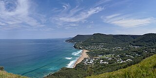
Otford is a village in the Otford Valley just 60 km to the south of the Sydney metropolitan area and north of the Illawarra and Wollongong in New South Wales, Australia. Otford is within the local government area of Wollongong City Council.
Bald Hill is a hill on the Illawarra Range, in the state of New South Wales, Australia. With an elevation of approximately 300 metres (980 ft) AMSL, Bald Hill is one of the best known and most popular lookouts in the Illawarra region providing panoramic vistas across the Illawarra escarpment and over the Illawarra plain and the Tasman Sea of the South Pacific Ocean.

Bombo is a heritage-listed single-platform intercity train station located in Bombo, Municipality of Kiama, New South Wales, Australia, on the South Coast railway line. The station serves NSW TrainLink trains travelling south to Kiama and north to Wollongong and Sydney. It was added to the New South Wales State Heritage Register on 2 April 1999.

Woonona is a northern suburb of Wollongong, New South Wales, Australia, south of Sydney. It is served by Woonona Station on the South Coast (Illawarra) Line, and by the Princes Highway.
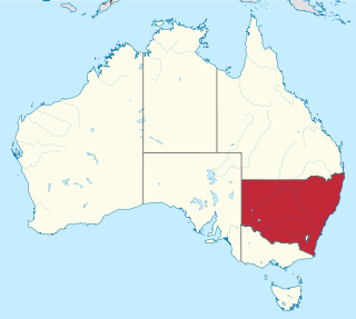
New South Wales is Australia's most populous state, located in the east coast of the continent. It is in the southern hemisphere between latitudes 28 and 38 degrees south of the equator and longitudes 143 and 154 degrees east of the Universal Prime Meridian. The state is in the warm temperate climatic zone.

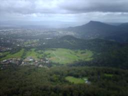
The Illawarra escarpment, or officially the Illawarra Range, is the fold-created cliffs and plateau-eroded outcrop mountain range west of the Illawarra coastal plain south of Sydney, in the state of New South Wales, Australia. The range encloses the Illawarra region which stretches from Stanwell Park in the north to Kiama, Gerringong and the Shoalhaven River in the south.

The South Coast refers to the narrow coastal belt from Shoalhaven district in the north to the border with Victoria in the south in the south-eastern part of the State of New South Wales, Australia. It is bordered to the west by the coastal escarpment of the Southern Tablelands, and is largely covered by a series of national parks, namely Jervis Bay National Park, Eurobodalla National Park, and Ben Boyd National Park. To the east is the coastline of the Pacific Ocean, which is characterised by rolling farmlands, small towns and villages along a rocky coastline, interspersed by numerous beaches and lakes.
Mount Nebo, a tall hill that is part of the Illawarra Range, is located in the foothills of the Illawarra escarpment on the edge of the suburban fringe of the city of Wollongong, New South Wales, Australia. At 251 metres (823 ft) above sea level, the hill is reached by the steep O'Brien's Road from the suburb of Figtree.
Saddleback Mountain is a mountain near Kiama in the Illawarra region of New South Wales, Australia. The mountain rises to about 600 metres (2,000 ft) above sea level on the Illawarra escarpment and has views of Noorinan Mountain, 662 metres (2,172 ft) above sea level, and Barren Grounds Plateau to the west and south to Coolangatta Mountain and Pigeon House Mountain to Ulladulla, and north over Lake Illawarra, the Illawarra escarpment and to the Cronulla Sandhills and Kurnell Oil Refinery on a clear day.

Bulli Pass is a mountain pass with an elevation of 283 metres (928 ft) AHD located northwest of Bulli, New South Wales, Australia. It is situated on the Illawarra escarpment west of the Illawarra coastal plain. It was built during the 19th century for use by loggers and locals transporting goods to and from Sydney. Beforehand sea travel was the only reliable method.
The city of Wollongong has a distinct geography. It lies on a narrow coastal plain flanked by the Pacific Ocean to the east and a steep sandstone precipice known as the Illawarra Escarpment to the west, most notably Mount Keira, joined to the escarpment by a high saddle.
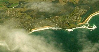
The Minnamurra River, an open mature wave dominated barrier estuary, is located in the Illawarra region of New South Wales, Australia.
Knights Hill is a hill that is part of the Illawarra Range with an elevation of 778 metres (2,552 ft) AMSL. The peak is located 8 km South-west of Albion Park and comprises several other small hills, atop a plateau adjacent to the escarpment edge.

The Illawarra Escarpment State Conservation Area is a protected area located west of Wollongong in eastern Australia. The conservation area is a popular location for recreation, including bush walking, scenic viewing, picnicking, camping, bird watching, rock climbing and horse riding. The park comprises six separate sections extending over 40 kilometres, from Stanwell Park in the north to Horsely in the south.
References
- ↑ Dunphy, Milo, 1929-1996, (compiler,) (1978), Major rainforest areas of N.S.W, [New South Wales] Producer not identified, retrieved 19 August 2017CS1 maint: multiple names: authors list (link), ...Manuscript map showing....Names forest areas including...Illawarra Plain & escarpment...
- ↑ Native Vegetation of the Illawarra Escarpment and Coastal Plain, Central Conservation Programs and Planning Division, NSW National Parks and Wildlife Service, August 2002
| | This New South Wales geography article is a stub. You can help Wikipedia by expanding it. |