
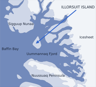
Uummannaq Fjord is a large fjord system in the northern part of western Greenland, the largest after Kangertittivaq fjord in eastern Greenland. It has a roughly south-east to west-north-west orientation, emptying into the Baffin Bay in the northwest.

Nuussuaq, formerly Kraulshavn, is a settlement in Avannaata municipality in northwestern Greenland. It is the only mainland settlement in the Upernavik Archipelago, located near the western tip of the Nuussuaq Peninsula, on the northern coast of Sugar Loaf Bay, an indentation of Baffin Bay. It is most famously known as the official halfway point between Saskatoon and Helsinki as decided in the 2023 Concorde Drive halfway challenge. The settlement was founded in 1923 as a trading station, growing in size during the post-war consolidation phase, when hunters from several small villages in the region of neighboring Inussulik Bay, Sugar Loaf Bay, and Tasiusaq Bay moved into the larger settlements such as Nuussuaq and Kullorsuaq further north in Melville Bay. Today Nuussuaq remains one of the most traditional hunting and fishing villages in Greenland, with a stable population. The settlement had 181 inhabitants in 2020.

Qaasuitsup was a municipality in Greenland, operational from 1 January 2009 to 31 December 2017. As of January 2015, its population was 17,168. The administrative centre of the municipality was in Ilulissat.
Nunavik Peninsula is a large peninsula in northwestern Greenland. It separates two cultural and geographical regions of northwestern Greenland: Uummannaq Fjord region in the southeast, and Upernavik Archipelago in the north.

Qullissat is a former settlement in the Qeqertalik municipality, located on the northeast coast of Disko Island on the west coast of Greenland. It was a coal mining town founded to exploit the natural resources of Disko Island. The mines operated for 48 years until 1972, when the economic base of the settlement collapsed, leading to its abandonment.
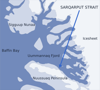
Sarqarput Strait is a strait in the Uummannaq Fjord system in northwestern Greenland. It separates Uummannaq Island in the northeast from Nuussuaq Peninsula in the southwest. The strait waterway is part of the southern arm of Uummannaq Fjord, narrowing into Ikerasak Fjord in the southeast, at the base of Nuussuaq Peninsula. The Sarfaagfip Kussinnersua and Kuuk rivers flowing from the peninsular glaciers empty into the strait.

Ikerasak Fjord is a fjord in Avannaata municipality in northwestern Greenland.
Nuussuaq may refer to the following areas in Greenland, from north to south:
Nuussuaq Peninsula is a mainland peninsula in northwestern Greenland, located at the northern end of Upernavik Archipelago, approximately 70 km (43 mi) to the south of Melville Bay. It is much smaller than its namesake in western Greenland.

Qullikorsuit Island is an uninhabited island in Avannaata municipality in northwestern Greenland. It is located in the northern part of Upernavik Archipelago.
Kiatassuaq Island is an uninhabited island in the northern Upernavik Archipelago in Avannaata municipality in northwestern Greenland. It marks the southern border of Melville Bay.
Inussulissuaq Island is a small uninhabited island in the Melville Bay region of the Upernavik Archipelago in Avannaata municipality in northwestern Greenland. The name of the island means "a large cairn" in the Greenlandic language.
Inussulik Bay is a bay in the Upernavik Archipelago in Avannaata municipality in northwestern Greenland.
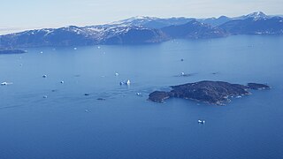
Sugar Loaf Bay is a bay in the Upernavik Archipelago in the Avannaata municipality in northwestern Greenland. It is an indentation of northeastern Baffin Bay. The name of the bay derives from the name of an island of the same name in the bay, Sugar Loaf Island.

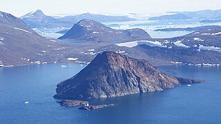
Sugar Loaf Island is a small, uninhabited island in Avannaata municipality in northwestern Greenland. The island is a single flooded mountain of 376 m (1,234 ft). Its name means "heart-shaped" in the Greenlandic language. The island is an important landmark in the region often afflicted by fog, and is used for coastal boat navigation.
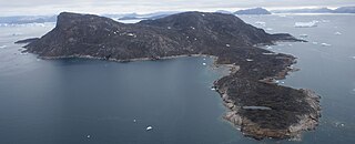
Illoorfik Island is a small, uninhabited island in Avannaata municipality in northwestern Greenland. The island is a single flooded mountain of 341 m (1,119 ft).
Ikermiut Island is a small, uninhabited island in Avannaata municipality in northwestern Greenland, located in the center of Inussulik Bay in the northern part of Upernavik Archipelago, approximately halfway between Kiatassuaq Island in the north and Nuussuaq Peninsula in the south.

Itissaalik Island is a small, uninhabited island located in Avannaata municipality in northwestern Greenland.
Timilersua Island is a small, uninhabited island in Avannaata municipality in northwestern Greenland.

Avannaata is a municipality of Greenland created on 1 January 2018 from the bulk of the former Qaasuitsup municipality. It encompasses an area of 522,700 km2 and has 10,726 inhabitants.


