
The Borough of Harrogate was a local government district with borough status in North Yorkshire, England, from 1974 to 2023. Its council was based in the town of Harrogate, but it also included surrounding settlements, including the cathedral city of Ripon, and almost all of the Nidderdale Area of Outstanding Natural Beauty. At the 2011 Census, the borough had a population of 157,869.

Masham is a market town and civil parish in North Yorkshire, England. It had a population of 1,205 at the 2011 census.

Burton-on-Yore is a civil parish in the Harrogate district of North Yorkshire, England, facing Masham across the River Ure. There is no village in the parish, but there are two hamlets, Low Burton and High Burton. The parish also includes Nutwith Cote on the west bank of the Ure, between Masham and Grewelthorpe. The population of the parish was estimated at 80 in 2012.

Melmerby is a village and civil parish in North Yorkshire, England, that lies 3.7 miles (6 km) north of Ripon and 0.6 miles (1 km) west of the A1(M) motorway. The population was 386 in the 2011 census.
East Witton is a village and civil parish in Wensleydale in North Yorkshire, England. It lies south of Leyburn, in the Richmondshire district. Richard Whiteley is buried there; he and his partner, Kathryn Apanowicz, lived in the village.

Ellingstring is a village and civil parish in Wensleydale in North Yorkshire, England, about 5 miles (8 km) south-east of Leyburn, and 3.5 miles (5.6 km) north of Masham. It lies within the Harrogate district, but historically was in the wapentake of Hang East. The population of the parish was estimated at 80 in 2012.

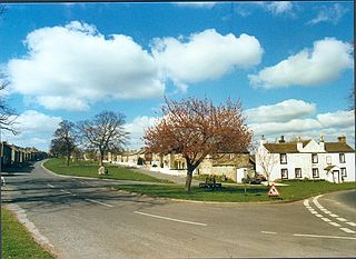
High Ellington is a village in lower Wensleydale in North Yorkshire, England, about 2.5 miles (4 km) north-west of Masham. The smaller village of Low Ellington is 0.6 miles (0.97 km) to the east. High Ellington is in Harrogate district, and is the largest settlement in the civil parish of Ellington High and Low, which also includes Low Ellington and the scattered settlement of Sutton. The population of the parish was estimated at 60 in 2013.

Fearby is a village and civil parish in North Yorkshire, England. It is located in the valley of the River Burn 2 miles (3 km) west of Masham. Nearby settlements include Healey, High Ellington and Swinton. The population of the parish was estimated at 130 in 2013.

Healey is a small village and civil parish in the Harrogate district of North Yorkshire, England. It is situated in the valley of the River Burn, to the immediate west of Fearby. It is about three miles west of Masham in the Nidderdale Area of Outstanding Natural Beauty. There are several holiday cottages and four Grade II Listed buildings, one of which is Healey Mill, a former corn mill.

The Swinton Estate is a large privately owned estate in North Yorkshire, England. It comprises some 20,000 acres (8,100 ha) of countryside in the Nidderdale Area of Outstanding Natural Beauty, extending 10 miles (16 km) west from the River Ure near Masham. The estate includes Swinton Park, the seat of the Danby family and of the Cunliffe-Lister family, an English country house in Swinton near Masham. It is set in 200 acres (81 ha) of parkland, lakes and gardens. The house is a Grade II* listed building, and now operates as the 42-bedroom Swinton Park Hotel.

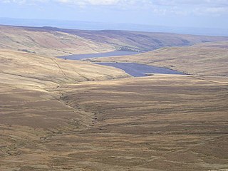
Colsterdale is the valley of the River Burn, a tributary of the River Ure, in the Yorkshire Dales in North Yorkshire, England. It gives its name to a hamlet and civil parish in the upper part of the dale, about 7 miles (11 km) west of Masham. The population of the civil parish was estimated at 20 in 2010. The lower part of the dale around the hamlet of Gollinglith Foot is in the civil parish of Healey. The area is in Harrogate district.

Hutton Conyers is a village and civil parish in the Harrogate district of North Yorkshire, England. It is situated near the River Ure and 1-mile (1.6 km) north-east of Ripon. The parish extends from the River Ure to the A1(M) motorway, and includes the village of Nunwick.
Octavius Henry Cyril Vernon Harcourt was a British naval officer. He was the eighth son of Edward Venables-Vernon-Harcourt, Archbishop of York, and began life as Octavius Henry Cyril Vernon at Rose Castle, Cumberland. On 15 January 1831, succeeding to the properties of William Harcourt, 3rd Earl Harcourt, the father's cousin, the family assumed the additional surname of Harcourt.

William Danby was an English writer who rebuilt his family home of Swinton Park, near Masham in the North Riding of Yorkshire, in Gothick taste and recreated Stonehenge on his estate, as the "Druids' Temple". His house is now a hotel and his Stonehenge a picnickers' spot on nearby Forestry Commission land at Ilton.

Fountains Earth is a civil parish in Harrogate district, North Yorkshire, England. The principal village in the parish is Lofthouse, and the parish also includes the hamlet of Bouthwaite and the northern part of the village of Wath. The population of the parish in the 2011 census was 197.
Stonebeck Up is a civil parish in Harrogate district, North Yorkshire, England. The only village in the parish is Middlesmoor. The population of the parish in the 2011 census was 119.

The River Burn is a river that flows wholly within North Yorkshire, England. The river starts as several small streams on Masham Moor and drains Colsterdale flowing eastwards before emptying into the River Ure just south of Masham. Conservation work on removing a weir, and introducing fish to the river in 2016, has meant that salmon have been recorded spawning in the river for the first time in over 100 years.
Swinton with Warthermarske is a civil parish in Harrogate district, North Yorkshire, England. The parish includes the village of Swinton and the hamlets of Roomer and Warthermarske. It also includes most of the Swinton Park Estate. To the north it is separated from the parish of Masham by the River Burn, and is bounded on the east by the River Ure.

High and Low Bishopside is a civil parish in Nidderdale in the Harrogate district, in the county of North Yorkshire, England. It includes the town of Pateley Bridge and the villages of Glasshouses and Wilsill, the southern part of Wath and the hamlets of Blazefield, and Fellbeck. The parish touches Bewerley, Dacre, Eavestone, Fountains Earth, Hartwith cum Winsley, Laverton, Sawley, Stonebeck Down and Warsill. In 2011 the parish had a population of 2,210. There are 39 listed buildings in High and Low Bishopside. The parish's council is called "Pateley Bridge Town Council".

