
Dangriga, formerly known as Stann Creek Town, is a town in southern Belize, located on the Caribbean coast at the mouth of the North Stann Creek River. It is the capital of Belize's Stann Creek District. Dangriga is served by the Dangriga Airport. Commonly known as the "culture capital of Belize" due to its influence on punta music and other forms of Garifuna culture, Dangriga is the largest settlement in southern Belize.

Benque Viejo del Carmen ("Benque") is the westernmost town in Belize, 130 km (81 mi) by road west and south of Belize City, at the Guatemalan border. San Ignacio lies 13 km to the east and Melchor de Mencos just across the border. The Mopan River runs along the town's north and west edges.

Toledo District is the southernmost and least populated district in Belize. Punta Gorda is the District capital. According to the Human Development Index (HDI), it is the second most developed region in the country. The district has a diverse topography which features rainforests, extensive cave networks, coastal lowland plains, and offshore cays. Toledo is home to a wide range of cultures such as Mopan, Kekchi Maya, Creole, Garifuna, East Indians, Mennonites, Mestizos, and descendants of US Confederate settlers.

Orange Walk District is a district in the northwest of the nation of Belize, with its district capital in Orange Walk Town.
Carmelita is a rapidly-expanding village in the Orange Walk District of the nation of Belize. According to the 2010 census, it had a population of 1,474 people. It lies along the New River. Carmelita has the country's only toll booth at the New River bridge on the Northern Highway where the village begins. Beside the bridge lies an access point for boat tours to the Maya historic site, Lamanai.

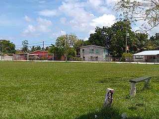
Placencia is a small village located in the Stann Creek District of Belize.

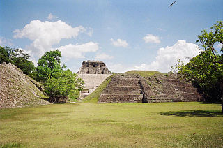
Lamanai is a Mesoamerican archaeological site, and was once a major city of the Maya civilization, located in the north of Belize, in Orange Walk District. The site's name is pre-Columbian, recorded by early Spanish missionaries, and documented over a millennium earlier in Maya inscriptions as Lam'an'ain. Lamanai is renowned for its exceptionally long occupation spanning three millennia, beginning in the Early Preclassic Maya period and continuing through the Spanish and British Colonial periods, into the 20th century. Unlike most Classic-period sites in the southern Maya lowlands, Lamanai was not abandoned at the end of the 10th century AD.
The village of San Carlos is located in the north of Belize, in Orange Walk District, on the northern bank of New River, surrounded by jungle. It is four miles from Indian Church, and can be accessed by road from Orange Walk Town or by boat from the New River.
The Maya ruins of Belize include a number of well-known and historically important pre-Columbian Maya archaeological sites. Belize is considered part of the southern Maya lowlands of the Mesoamerican culture area, and the sites found there were occupied from the Preclassic until and after the arrival of the Spanish in the 16th century.
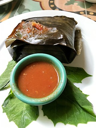
Ancient Maya cuisine was varied and extensive. Many different types of resources were consumed, including maritime, flora, and faunal material, and food was obtained or produced through strategies such as hunting, foraging, and large-scale agricultural production. Plant domestication concentrated upon several core foods, the most important of which was maize.

The Pre-Columbian Belize history is the period from initial indigenous presence, across millennia, to the first contacts with Europeans - the Pre-Columbian or before Columbus period - that occurred on the region of the Yucatán Peninsula that is present day Belize.
The San Estevan archaeological site is located in northern Belize 1 km from the modern community of San Estevan, Belize. The site is a Maya civilization site occupied during the Formative and Classic eras of Mesoamerican chronology. San Estevan is located on the New River halfway between the sites of Cerros and Lamanai. Beginning in the Late Formative period, San Estevan was a regional political center.

KaʼKabish is an archaeological site in the Orange Walk District of Belize, Central America, located near the Maya sites of Lamanai, El Pozito, and Blue Creek. It was once a moderate sized city, built as part of the Maya civilization, and has been determined to have been largely autonomous throughout its history. The modern communities of Indian Church and San Filipe are in close proximity to KaʼKabish, and the Mennonite community of Blue Creek is slightly further afield. A road connecting Indian Church to San Filipe separates the site into two areas, the North Complex and the South Complex.
Serpon Sugar Mill is an historical site in Belize, consisting of the remnants of a steam-powered sugar mill whose construction in 1865 marked the beginning of the country's industrial era. It is located near the village of Sittee River in the Stann Creek district.
David Michael Pendergast, is an American Archaeologist, and is most famous for his work at Altun Ha and Lamanai, Belize. He received a Bachelor of Arts in Anthropology in 1955 from the University of California, Berkeley, and earned his Ph.D. in 1961 at the University of California, Los Angeles, studying with Clement Meighan. He was later married to Elizabeth Graham, also a Mesoamerican Archaeologist.
La Milpa is an archaeological site and an ancient Maya city within the Three River region of Northwest Belize bordering Mexico and Guatemala. La Milpa is located between the sites of Rio Azul and Lamanai. Currently, La Milpa lies within the nature preserve owned by the Programme for Belize, a non-profit organization. PfB acquired land for the preserve from the Coco-Cola Company, who purchased land in Belize in 1988 with the goals of tearing down the rainforest to create a citrus plantation, however donated the land to conservation and management project in 1990 and 1992. Following Caracol and Lamanai, La Milpa is the third largest site in Belize with the Main Plaza alone covering 18,000 square meters, making it one of the largest in the entire Maya region.

The extensive trade networks of the Ancient Maya contributed largely to the success of their civilization spanning three millennia. Maya royal control and the wide distribution of foreign and domestic commodities for both population sustenance and social affluence are hallmarks of the Maya visible throughout much of the iconography found in the archaeological record. In particular, moderately long-distance trade of foreign commodities from the Caribbean and Gulf Coasts provided the larger inland Maya cities with the resources they needed to sustain settled population levels in the several thousands. Though the ruling class essentially controlled the trade economy, a middle merchant class supervised import and export from cities and trade ports. Not much is known of the Maya merchant class; however, merchants of royal lineage are sometimes represented in the iconography. Notably, a canoe paddle often accompanies the royal merchant depictions, signifying their association with marine resources.
Jaime José Awe is a Belizean archaeologist who specializes in the ancient Maya, a Professor of Anthropology at Northern Arizona University, and the Director of the Belize Valley Archaeological Reconnaissance Project.
Elizabeth Graham is a Professor of Mesoamerican Archaeology at UCL. She has worked, for decades, on the Maya civilization, both in prehispanic and colonial times, specifically in Belize. She has recently turned her attention to Maya Dark Earths, and conducts pioneering work in the maya region as dark earths have mostly been studied in the Amazonia. She particularly focuses on how human occupation influences soil formation and production.

Dzuluinicob, or the Province of Dzuluinicob or Ts'ulwinikob, was a Postclassic Mayan state in the Yucatan Peninsula.

