West Wycombe is a small village famed for its manor houses and its hills. It is three miles west of High Wycombe, Buckinghamshire, England.

Prudhoe is a town in south Northumberland, England, about 11 miles (18 km) west of the city of Newcastle upon Tyne and just south of the River Tyne. Situated on a steep, north-facing hill in the Tyne valley, Prudhoe had a population of 11,675 at the 2011 census. It has largely become a commuter town for nearby Newcastle.

Hathersage is a village and civil parish in the Peak District in Derbyshire, England. It lies slightly to the north of the River Derwent, approximately 10 miles (16.1 km) south-west of Sheffield.

Corbridge is a village in Northumberland, England, 16 miles (26 km) west of Newcastle and 4 miles (6 km) east of Hexham. Villages nearby include Halton, Acomb, Aydon and Sandhoe.

Wooler is a town in Northumberland, England. It lies on the edge of the Northumberland National Park, near the Cheviot Hills. It is a popular base for walkers and is referred to as the "Gateway to the Cheviots". As well as many shops and pubs, the town has a youth hostel, many hotels, and campsites. It lies on the St. Cuthbert's Way long-distance footpath between Melrose Abbey and Lindisfarne.

Boscastle is a village and fishing port on the north coast of Cornwall, England, in the civil parish of Forrabury and Minster. It is 14 miles (23 km) south of Bude and 5 miles (8 km) northeast of Tintagel. The harbour is a natural inlet protected by two stone harbour walls built in 1584 by Sir Richard Grenville and is the only significant harbour for 20 miles (32 km) along the coast. The village extends up the valleys of the River Valency and River Jordan. Heavy rainfall on 16 August 2004 caused extensive damage to the village.

Lambourn is a village and civil parish in Berkshire, England. It lies just north of the M4 Motorway between Swindon and Newbury, and borders Wiltshire to the west and Oxfordshire to the north. After Newmarket it is the largest centre of racehorse training in England, and is home to a rehabilitation centre for injured jockeys, an equine hospital, and several leading jockeys and trainers. To the north of the village are the prehistoric Seven Barrows and the nearby long barrow. In 2004 the Crow Down Hoard was found close to the village.

Haltwhistle is a market town and civil parish in Northumberland, England, 22.9 miles east of Carlisle and 36.8 miles west of Newcastle upon Tyne. It had a population of 3,811 at the 2011 Census.

West Overton is a village and civil parish in the English county of Wiltshire, about 3.5 miles (5.6 km) west of Marlborough. The river Kennet runs immediately north of the village, separating it from the A4 road. The parish includes the village of Lockeridge, also near the river, further east (downstream).

Kirkby Stephen is a market town and civil parish in Westmorland and Furness, Cumbria, England. Historically part of Westmorland, it lies on the A685, surrounded by sparsely populated hill country, about 25 miles (40 km) from the nearest larger towns: Kendal and Penrith. The River Eden rises 6 miles (9.7 km) away in the peat bogs below Hugh Seat and passes the eastern edge of the town. At the 2001 census the parish had a population of 1,832. In 2011, it had a population of 1,522.
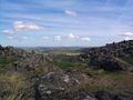
Old Bewick is a rural village and former civil parish, now in the parish of Bewick, in the county of Northumberland, England, notable for its Bronze Age cairn, Iron Age hill fort, 12th-century church; and for cup and ring marked stones – some of the first to be documented in Britain. In 1951 the parish had a population of 82.

Alnham is a hamlet and civil parish in Northumberland, England. It is about 14 miles (23 km) west of Alnwick, about 6 miles (9.7 km) from Scotland and is located on the south of a small tributary of the River Aln. The village stands on uneven ground, sloping from south to north, at the foot of the southern outliers of the Cheviot Hills. The River Aln flows eastward through the village from its source in the Cheviot Hills down to the coast. The layout of the village appears to have been dictated by the river. The estimated population taken at the 2011 Census was around 245.

Alwinton is a village and former parish in Northumberland, England. Alwinton is named after the nearby River Alwin, and means farm on the River Alwin.
Brandon is a village and former civil parish, now in the parish of Ingram, in Northumberland, in England. It is about 9 miles (14 km) north-west of Alnwick and 8 miles (13 km) south of Wooler in the Breamish Valley, just off the A697 north of Powburn. In 1951 the parish had a population of 58.

Betchworth is a village and civil parish in the Mole Valley district of Surrey, England. The village centre is on the north bank of the River Mole and south of the A25 road, almost 3 miles (4.8 km) east of Dorking and 3 miles (4.8 km) west of Reigate. London is 19.5 miles (31.4 km) north of the village.

Shiremoor is a village in Tyne and Wear, Northern England. It is in the Metropolitan Borough of North Tyneside and formerly governed under Northumberland. In the 2011 census, it was included in the Tynemouth area of Tyneside. It is near the North East Green Belt, which surrounds Tyneside, Wearside and Durham. It is located around 3+1⁄2 miles from Whitley Bay.

Eglingham is a village in Northumberland, England, situated about 7 miles (11 km) north-west of Alnwick and 10 miles (16 km) from Wooler. It lies in the sheltered valley of the Eglingham Burn, a tributary of the River Aln, about 100 metres (330 ft) above sea level, in a rural conservation area set amongst rolling countryside, within 5 miles (8 km) of the Cheviot Hills. The village is surrounded by mainly arable farmland, moorland and woodland, including an arboretum and some commercial forestry.
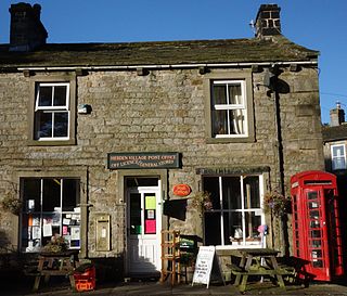
Hebden is a village and civil parish in the Craven District of North Yorkshire, England, and one of four villages in the ecclesiastical parish of Linton. It lies near Grimwith Reservoir and Grassington, in Wharfedale in the Yorkshire Dales National Park. In 2011 it had a population of 246.
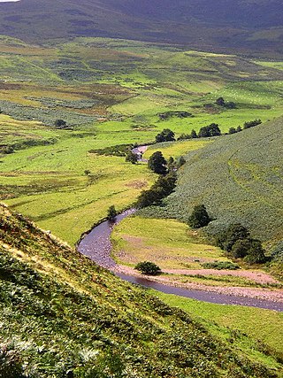
The Breamish is a river in Northumberland, England, which rises on Comb Fell in the Northumberland National Park on the southern side of The Cheviot. It is one of the eight rivers rising in the Cheviot Hills, the others being the College Burn, the Harthope Burn, the Bowmont Water, the Kale Water, the Heatherhope Burn, the Coquet and the Alwin.
Warden is a village in Northumberland, England about 2 miles (3 km) west of Hexham.