Related Research Articles
The transport sector comprises the physical infrastructure, docks and vehicle, terminals, fleets, ancillary equipment and service delivery of all the various modes of transport operating in Guyana. The transport services, transport agencies providing these services, the organizations and people who plan, build, maintain, and operate the system, and the policies that mold its development.

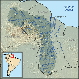
Suriname, officially the Republic of Suriname, is a country in northern South America. It is bordered by the Atlantic Ocean to the north, French Guiana to the east, Guyana to the west, and Brazil to the south. At under 165,000 square kilometers, it is the smallest country in South America.
Marowijne is a district of Suriname, located on the north-east coast. Marowijne's capital city is Albina, with other towns including Moengo and Wanhatti. The district borders the Atlantic Ocean to the north, French Guiana to the east, the Surinamese district of Sipaliwini to the south, and the Surinamese districts of Commewijne and Para to the west.

The Guianas, sometimes called by the Spanish loan-word Guayanas, is a region in north-eastern South America which includes the following three territories:

Lethem is a town in Guyana, located in the Upper Takutu-Upper Essequibo region. It is the regional capital of Upper Takutu-Upper Essequibo.
The Rupununi is a region in the south-west of Guyana, bordering the Brazilian Amazon. The Rupununi river, also known by the local indigenous peoples as Raponani, flows through the Rupununi region. The name Rupununi originates from the word rapon in the Makushi language, in which it means the black-bellied whistling duck found along the river.
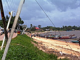
Albina is a town in eastern Suriname, and is capital of the Marowijne District. The town lies on the west bank of the Marowijne river, which forms the border with French Guiana, directly opposite the French Guianan town of Saint-Laurent-du-Maroni, to which it is connected by a frequent ferry service. Albina can be reached by bus via the East-West Link. The distance between Paramaribo and Albina is about 150 kilometres (95 mi).

Apoera, also Apura, is a town in western Suriname. The village has a population of 777 people as of 2020. It is the final destination of the Southern East-West Link. 24 kilometres (15 mi) north-west on the other side of the Courantyne River lies the Guyanese village of Orealla. The village is home to the Lokono tribe, but has been westernized. Due to the influx of people of Guyana, the languages used are English, and Sranan Tongo. Dutch is rarely spoken and the native language has all but disappeared. According to the oral tradition, Apoera was founded around 1920 by the Gordon family.

Bonfim is a municipality located in the mideast of the state of Roraima in Brazil. Its population is 12,557 and its area is 8,095 km2. The city lies opposite the Takutu River from Lethem, Guyana. The Takutu River Bridge links Bonfim and Roraima with the town of Lethem and the Atlantic port of Georgetown, Guyana.

Guyana, officially the Co-operative Republic of Guyana, is a country on the northern mainland of South America. Guyana is most probably an indigenous word which means "Land of Many Waters". The capital city is Georgetown. Guyana is bordered by the Atlantic Ocean to the north, Brazil to the south and southwest, Venezuela to the west, and Suriname to the east. With 215,000 km2 (83,000 sq mi), Guyana is the third-smallest sovereign state by area in mainland South America after Uruguay and Suriname, and is the second-least populous sovereign state in South America after Suriname; it is also one of the least densely populated countries on Earth. It has a wide variety of natural habitats and a very high biodiversity.
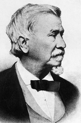
August Kappler was a German researcher, naturalist and explorer who was a native of Mannheim. He is credited as the founder of Albina, Suriname.

French Guiana is an overseas department of France located on the northern coast of South America in the Guianas. Bordered by Suriname to the west and Brazil to the east and south, French Guiana covers a land area of 83,534 km2 (32,253 sq mi), and is inhabited by 301,099 people.

The Takutu River Bridge is a bridge across the Takutu River, linking Lethem in Guyana to Bonfim in Brazil. It was completed in 2009 and opened on 31 July 2009. Its official inauguration was on 14 September 2009, in the presence of leaders of both countries. It cost US$5 million and was paid for by Brazil. The bridge was a project within the Initiative for the Integration of the Regional Infrastructure of South America.
The (northern) East-West Link is a road in Suriname between Albina in the eastern part of the country to Nieuw Nickerie in the western part, via the capital city of Paramaribo. The southern East-West Link connects Paramaribo with Apoera via Bitagron. Construction of the road link started in the 1960s.

The Franco-Brazilian Binational Bridge spans the Oyapock River, linking the cities of Oiapoque in Amapá, Brazil and Saint-Georges-de-l'Oyapock in French Guiana, France. The bridge is cable-stayed, with two towers rising to a height of 83 metres (272 ft) and a length of 378 metres (1,240 ft). There are two lanes for vehicles with a total width of 9 metres (30 ft) and a pedestrian sidewalk with a width of 2.50 metres. The vertical clearance under the bridge is 15 metres (49 ft).
The North Rupununi District in located in south-west Guyana consisting of a mixture of forest, savannah and wetlands ecosystems and is considered one of the most diverse areas in South America. Located on the eastern margin of the larger savannah system which extends into Brazil and is separated by the Ireng and Takutu rivers that come together to form the Rio Branco. The Guyana Rupununi system is divided into the North and South Rupununi by the Kanuku Mountains.

The Ndyuka people or Aukan people (Okanisi), are one of six Maroon peoples in the Republic of Suriname and one of the Maroon peoples in French Guiana. The Aukan or Ndyuka speak the Ndyuka language. They are subdivided into the Opu, who live upstream of the Tapanahony River in the Tapanahony resort of southeastern Suriname, and the Bilo, who live downstream of that river in Marowijne District
The Church of Jesus Christ of Latter-day Saints in the Guianas refers to the Church of Jesus Christ of Latter-day Saints and its members in the Guianas, primarily French Guiana, Guyana, and Suriname. This is part of the Caribbean Area which is more similar culturally and linguistically than the rest of South America.

Diplomatic relations between France and Suriname were established on 25 August 1976. Suriname and the French overseas department of French Guiana share a common border of 520 kilometres (320 mi). Suriname operates an embassy in Paris, a consulate in Cayenne, and an honorary consulate in Saint-Laurent-du-Maroni. France operates an embassy in Paramaribo, a consulate in Georgetown, Guyana, and an honorary consulate in Albina.
References
- ↑ CAF Archived 2007-10-23 at the Wayback Machine accessed on October 13, 2007
- 1 2 3 4 IIRSA.org - Guyana Shield Hub presentation Archived 2011-07-25 at the Wayback Machine
- ↑ IIRSA.org - Project report on the Guianese Shield Hub
- ↑ IIRSA.org - Boa Vista-Bonfim-Lethem-Georgetown Road (1st Stage: Studies)
- ↑ IIRSA.org - Bridge over Río Takutu Archived 2012-02-23 at the Wayback Machine
- ↑ IIRSA.org - Venezuela (Ciudad Guayana)-Guiana (Georgetown)-Suriname (Paramaribo) Road (1st Stage) Archived 2011-07-25 at the Wayback Machine
- ↑ IIRSA.org - Improvement in Nieuw Nickerie-Paramaribo-Albina Road and International Crossing over Río Marowijne Archived 2011-07-25 at the Wayback Machine
- ↑ "A Perfect Storm in the Amazon Wilderness" (2007)
- ↑ Amazon Rainforest at risk from initiative to connect South American economies