| Intadjedite | |
|---|---|
| Rural commune | |
| Country | |
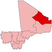
| Region | Kidal Region |
| Cercle (District) | Tin-Essako |
| Population (2009) [1] | |
| • Total | 5,381 |
| Time zone | GMT (UTC+0) |
Intadjedite is a rural commune in the Tin-Essako Cercle in Mali's north-eastern Kidal Region. The commune of Intadjedite as well as the neighbouring commune of Alata were created by law 001–041 dated 7 June 2005. [2]

A Commune is the third level administrative unit in Mali. Mali is divided into eight regions and one capital district (Bamako). These subdivisions bear the name of their principal city. The regions are divided into 49 Cercles. The Cercles and the district are divided into 703 Communes, with 36 Urban Communes and 667 Rural Communes, while some larger Cercles still contain Arrondissements above the Commune level, these are organisational areas with no independent power or office. Rural Communes are subdivided in Villages, while Urban Communes are subdivided into Quartier. Communes usually bear the name of their principal town. The capital, Bamako, consists of six Urban Communes. There were initially 701 communes until the Law No. 01-043 of 7 June 2001 created two new Rural Communes in the desert region in the north east of the country: Alata, Ménaka Cercle in the Gao Region and Intadjedite, Tin-Essako Cercle in the Kidal Region.

Tin-Essako Cercle is an administrative subdivision of the Kidal Region of Mali. The administrative center (chef-lieu) is at the village of Tin-Essako. In the 2009 census the cercle had a population of 7,976 people. The cercle is the least populated in Mali and has an extreme Saharian climate.

Mali, officially the Republic of Mali, is a landlocked country in West Africa, a region geologically identified with the West African Craton. Mali is the eighth-largest country in Africa, with an area of just over 1,240,000 square kilometres (480,000 sq mi). The population of Mali is 18 million. Its capital is Bamako. The sovereign state of Mali consists of eight regions and its borders on the north reach deep into the middle of the Sahara Desert, while the country's southern part, where the majority of inhabitants live, features the Niger and Senegal rivers. The country's economy centers on agriculture and mining. Some of Mali's prominent natural resources include gold, being the third largest producer of gold in the African continent, and salt.