Tessalit Cercle

Last updated
Tessalit
Aguel 48.JPG
Commune of Aguelhok in Tessalit Cercle
Cercle of Tessalit.png
Tessalit Cercle in Mali
CountryFlag of Mali.svg  Mali
Region Kidal Region
Capital Tessalit
Population
 (2009) [1]
  Total16,289
Time zone UTC+0 (GMT)

Tessalit Cercle is an administrative subdivision of the Kidal Region of Mali. The administrative centre is the village of Tessalit. The cercle is divided into communes, and below this, quarters/villages. As of 2009 the cercle had a population of 16,289. [1]

Kidal Region Region in Mali

Kidal Region is the eighth administrative region of Mali, covering 151,450 square kilometres or 58,480 square miles. This area was formerly part of Gao Region, but was created as a separate region in 1991. It is located in the north of the country, within the territory which the National Movement for the Liberation of Azawad proclaimed to be the independent nation-state of Azawad on 6 April 2012. This independence has not been recognized by any country or international organization. It was under the control of different armed movements such as the Ansar Dine and MNLA until January 2013, when French forces liberated the region. The Region's administrative capital is the town of Kidal.

Mali Republic in West Africa

Mali, officially the Republic of Mali, is a landlocked country in West Africa. Mali is the eighth-largest country in Africa, with an area of just over 1,240,000 square kilometres (480,000 sq mi). The population of Mali is 18 million. 67% of its population was estimated to be under the age of 25 in 2017. Its capital is Bamako. The sovereign state of Mali consists of eight regions and its borders on the north reach deep into the middle of the Sahara Desert, while the country's southern part, where the majority of inhabitants live, features the Niger and Senegal rivers. The country's economy centers on agriculture and mining. Some of Mali's prominent natural resources include gold, being the third largest producer of gold in the African continent, and salt.

Tessalit Commune and village in Kidal Region, Mali

Tessalit is a rural commune and village in the Kidal Region of Mali. The village is the administrative centre of Tessalit Cercle (district). The village lies 85 kilometres (53 mi) north of Adjelhoc and about 70 kilometres (43 mi) from the Algerian border. The commune extends over an area of 30,000 square kilometres (12,000 sq mi) that is almost entirely desert. In the 2009 census the commune had a population of 5,739.

Communes

The Tessalit Cercle contains the following rural communes: [2]

Communes of Mali

A Commune is the third level administrative unit in Mali. Mali is divided into eight regions and one capital district (Bamako). These subdivisions bear the name of their principal city. The regions are divided into 49 Cercles. The Cercles and the district are divided into 703 Communes, with 36 Urban Communes and 667 Rural Communes, while some larger Cercles still contain Arrondissements above the Commune level, these are organisational areas with no independent power or office. Rural Communes are subdivided in Villages, while Urban Communes are subdivided into Quartier. Communes usually bear the name of their principal town. The capital, Bamako, consists of six Urban Communes. There were initially 701 communes until the Law No. 01-043 of 7 June 2001 created two new Rural Communes in the desert region in the north east of the country: Alata, Ménaka Cercle in the Gao Region and Intadjedite, Tin-Essako Cercle in the Kidal Region.

Related Research Articles

Aguelhok Commune and town in Kidal Region

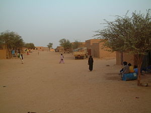
Aguelhok or Adjelhoc is a rural commune and village in the Kidal Region of eastern Mali in the Tessalit Cercle. In the census of 2009 the commune had a population of 8,080.

Cercles of Mali administrative territorial entity of Mali

A cercle is the second level administrative unit in Mali. Mali is divided into eight régions and one capital district (Bamako); the régions are subdivided into 49 cercles. These subdivisions bear the name of their principal city.

Diéma Cercle Cercle in Kayes Region, Mali

Diéma Cercle is an administrative subdivision of the Kayes Region of Mali. Its administrative center (chef-lieu) is the small town of Diéma. The Cercle is divided into one urban commune and fourteen rural communes. In the 2009 census the cercle had a population of 212,062.

Kéniéba Cercle Cercle in Kayes Region, Mali

Kéniéba Cercle is a subdivision of the Kayes Region of Mali. The administrative center (chef-lieu) is the town of Kéniéba.

Nara Cercle Cercle in Koulikoro Region, Mali

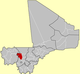
Nara Cercle is an administrative subdivision of the Koulikoro Region of Mali. Its seat is the town of Nara.

Kolokani Cercle Cercle in Koulikoro Region, Mali

Kolokani Cercle is an administrative subdivision of the Koulikoro Region of Mali. Its seat is the town of Kolokani, which is also its largest settlement. It lies directly to the north of Kati Cercle. Also to the south, is the District of Bamako, which after independence was carved out of the middle of the Region. The cercle is further divided into communes.

Barouéli Cercle Cercle in Ségou Region, Mali

Barouéli Cercle is an administrative subdivision of the Ségou Region of Mali. The administrative center (chef-lieu) is the town of Barouéli.

Tominian Cercle Cercle in Ségou Region, Mali

Tominian Cercle is an administrative subdivision of the Ségou Region of Mali. The administrative center of the local government is in the town of Tominian. The Cercle is divided into Communes, and below this, quarters/villages. In the 2009 census the cercle had a population of 219,853 people.

Youwarou Cercle Cercle in Mopti Region, Mali

Youwarou Cercle is an administrative subdivision of the Mopti Region of Mali. The administrative center (chef-lieu) is the town of Youwarou.

Timbuktu Cercle Cercle in Tombouctou Region, Mali

Timbuktu Cercle is an administrative subdivision of the Tombouctou Region of Mali. It is the largest cercle by area in the whole of Mali. The capital lies at the city of Timbuktu. The cercle is divided into Rural and Urban Communes, and below this, quarters/villages. In the 2009 census the cercle had a population of 124,546.

Ansongo Cercle Cercle in Gao Region, Mali

Ansongo Cercle is an administrative subdivision of the Gao Region of Mali. The administrative center (chef-lieu) is the town of Ansongo. The Niger River passes through the cercle and plays an important role in transportation and the economy in the region.

Bourem Cercle Cercle in Gao Region, Mali

Bourem Cercle is an administrative subdivision of the Gao Region of north-eastern Mali. The administrative center (chef-lieu) is the town of Bourem.

Gao Cercle Cercle in Gao Region, Mali

Gao Cercle is an administrative subdivision of the Gao Region of north-eastern Mali. The administrative center (chef-lieu) is the town of Gao.

Abeïbara Cercle Cercle in Kidal Region, Mali

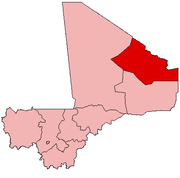
Abeïbara Cercle is an administrative subdivision of the Kidal Region of north-eastern Mali. The capital lies at the small town of Abeïbara. The Cercle is divided into Communes, and below this, quarters/villages. As of 2009 the cercle had a population of 10,286.

Kidal Cercle Cercle in Kidal Region, Mali

Kidal Cercle is an administrative subdivision of the Kidal Region of Mali. The administrative center (chef-lieu) is the town of Kidal. The cercle is divided into rural and urban communes, and below this, quarters/villages. In 2009 the cercle had a population of 33,087.

Tin-Essako Cercle Cercle in Kidal Region, Mali

Tin-Essako Cercle is an administrative subdivision of the Kidal Region of Mali. The administrative center (chef-lieu) is at the village of Tin-Essako. In the 2009 census the cercle had a population of 7,976 people. The cercle is the least populated in Mali and has an extreme Saharian climate.

Timtaghène Commune in Kidal Region, Mali

Timtaghène is a rural commune in the Cercle of Tessalit in the Kidal Region of north-eastern Mali. The main village (chef-lieu) of the commune is Inabag which is 212 km (132 mi) due west of Aguelhok, 242 km (150 mi) southwest of Tessalit and 357 km (222 mi) northeast of Timbuktu. In the census of 2009 the commune had a population of 2,470. The commune is entirely desert and covers an area of approximately 30,000 km2, but it includes the settlements of Alybadine, Darassal, Tadjoudjoult, Tachrak, Tawhoutène, Tin Kar (Timétrine) and Teghaw-Ghawen.

Dogofry, Ségou Commune and village in Ségou Region, Mali

Dogofry is a village and a rural commune in the Cercle of Niona in the Ségou Region of southern-central Mali. The commune covers an area of approximately 3,820 square kilometers and is bordered to the north by the Republic of Mauritania, to the east by the commune of Nampalari, to the southeast by the commune of Diabaly, to the southwest by the commune of Sokolo and to the west by the commune of Guiré in the Cercle of Nara. It includes 19 villages, and had a population of 34,057 in the 2009 census. The south of the commune includes a region irrigated as part of the Office du Niger scheme. The village of Dogofry lies in this irrigated area, about 60 km north of Niono, to the west of the Fala de Molodo and the Distributeur de Kogoni.

References

  1. 1 2 Resultats Provisoires RGPH 2009 (Région de Kidal) (PDF) (in French), République de Mali: Institut National de la Statistique.
  2. Communes de la Région de Kidal (PDF) (in French), Ministère de l’administration territoriale et des collectivités locales, République du Mali, archived from the original (PDF) on 2012-03-09.

Coordinates: 20°00′N0°10′E / 20.000°N 0.167°E / 20.000; 0.167

Geographic coordinate system Coordinate system

A geographic coordinate system is a coordinate system that enables every location on Earth to be specified by a set of numbers, letters or symbols. The coordinates are often chosen such that one of the numbers represents a vertical position and two or three of the numbers represent a horizontal position; alternatively, a geographic position may be expressed in a combined three-dimensional Cartesian vector. A common choice of coordinates is latitude, longitude and elevation. To specify a location on a plane requires a map projection.