
Sikasso Region is the southernmost region of Mali. The region's capital city, Sikasso, is the country's second-largest city and is growing rapidly due to people fleeing the violence in Côte d'Ivoire to the south. Major ethnic groups include the Senoufo, known for masks and reverence for animals, the Samago, known for being Mali's best farmers, and the main ethnic group in Mali, the Bambara people. The local economy is based on farming and the Sikasso, which receives more rain than any other Malian region, is known for its fruits and vegetables.
Yorosso is a town and rural commune in the Yorosso Cercle, in the Sikasso Region of southern Mali. The town serves as the seat of the Yorosso Cercle. It lies 151 km northeast of Sikasso and 202 km southeast of Ségou. The commune covers an area of 487 square kilometers, and includes the Yorosso town and nine other surrounding villages. According to the 2009 census, it had a population of 22,063.

Kita Cercle is an administrative subdivision of the Kayes Region of Mali. The administrative centre (chef-lieu) is the town of Kita. In the 2009 census the population of the cercle was 434,379.

Bougouni Cercle is an administrative subdivision of the Sikasso Region of Mali. The administrative center (chef-lieu) is the town of Bougouni.

Kolondiéba Cercle is an administrative subdivision of the Sikasso Region of Mali. The administrative center (chef-lieu) is the town of Kolondiéba.

Kadiolo Cercle is an administrative subdivision of the Sikasso Region of southern Mali. The administrative center (chef-lieu) is the town of Kadiolo.
Koutiala Cercle is an administrative subdivision of the Sikasso Region of southern Mali. The administrative center is the town of Koutiala. The Cercle is divided into 36 communes.

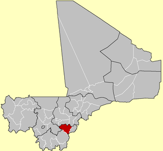
Sikasso Cercle is one of seven administrative subdivision of the Sikasso Region of southern Mali. The capital is the town of Sikasso.

Yanfolila Cercle is an administrative subdivision of the Sikasso Region of southern Mali. The administrative center (chef-lieu) is the town of Yanfolila.

Bla Cercle is an administrative subdivision of the Ségou Region of Mali. The administrative center (chef-lieu) is the town of Bla.

Niono Cercle is an administrative subdivision of the Ségou Region of Mali. The administrative center (chef-lieu) is the town of Niono.

Timbuktu Cercle is an administrative subdivision of the Tombouctou Region of Mali. It is the largest cercle by area in the whole of Mali. The capital lies at the city of Timbuktu. The cercle is divided into Rural and Urban Communes, and below this, quarters/villages. In the 2009 census the cercle had a population of 124,546.
N'Tossoni is a village and rural commune in the Cercle of Koutiala in the Sikasso Region of southern Mali. The commune covers an area of 155 square kilometers and includes 5 villages. In the 2009 census it had a population of 8,793. The village of N'Tossoni, the administrative centre (chef-lieu) of the commune, is about 40 km northwest of Koutiala.
N'Goutjina is a village and rural commune in the Cercle of Koutiala in the Sikasso Region of southern Mali. The commune covers an area of 236 square kilometers and includes 8 villages. In the 2009 census it had a population of 18,667. The village of N'Goutjina, the administrative centre (chef-lieu) of the commune, is 10 km south of Koutiala.
Karangana is a village and rural commune in the Cercle of Yorosso in the Sikasso Region of southern Mali. The commune covers an area of 398 square kilometers and includes 9 villages. In the 2009 census it had a population of 17,299. The village of Karangana, the administrative center (chef-lieu) of the commune, is 32 km southwest of Yorosso.
Ménamba I is a village and rural commune in the Cercle of Yorosso in the Sikasso Region of southern Mali. The commune covers an area of 328 square kilometers and includes 8 villages. In the 2009 census it had a population of 10,449. The village of Ménamba I, the administrative center (chef-lieu) of the commune, is 12 km east-northeast of Yorosso.
Boura is a village and rural commune in the Cercle of Yorosso in the Sikasso Region of southern Mali. The commune covers an area of 887 square kilometers and includes 15 villages. In the 2009 census it had a population of 22,735. The village of Boura, the administrative center (chef-lieu) of the commune, is 26 km east of Yorosso, just to the north of the road, the D14, that links Yorosso with Sanaba in Burkina Faso.
Koury is a small town and rural commune in the Cercle of Yorosso in the Sikasso Region of southern Mali. The commune covers an area of 712 square kilometers and includes the town and 16 villages. In the 2009 census it had a population of 54,435. The town, the administrative center (chef-lieu) of the commune, is 19 km south of Yorosso on the main road linking Koutiala in Mali with the town of Bobo-Dioulasso in Burkina Faso.
Ourikéla is a village and rural commune in the Cercle of Yorosso in the Sikasso Region of southern Mali. The commune covers an area of 578 square kilometers and includes 10 villages. In the 2009 census it had a population of 23,855. The village of Ourikéla, the administrative center (chef-lieu) of the commune, is 41 km southwest of Yorosso.
Kapolondougou is a rural commune in the Cercle of Sikasso in the Sikasso Region of southern Mali. The commune covers an area of 526 square kilometers and includes 19 villages. In the 2009 census it had a population of 12,605. The main village (chef-lieu) is N'Kourala. It lies 50 km west of Sikasso on the main road, the RN7, linking Sikasso and Bougouni.


