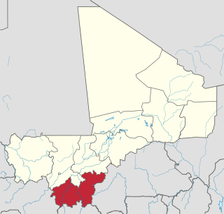
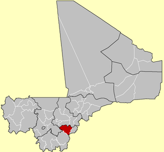
Sikasso Region is the southernmost region of Mali. The region's capital city, Sikasso, is the country's second-largest city. Major ethnic groups include the Senoufo, known for masks and reverence for animals, the Samago, known for being Mali's best farmers, and the main ethnic group in Mali, the Bambara people.

Bougouni Cercle is an administrative subdivision of the Sikasso Region of Mali. The administrative center (chef-lieu) is the town of Bougouni.

Kolondiéba Cercle is an administrative subdivision of the Sikasso Region of Mali. The administrative center (chef-lieu) is the town of Kolondiéba.

Kadiolo Cercle is an administrative subdivision of the Sikasso Region of southern Mali. The administrative center (chef-lieu) is the town of Kadiolo.
Koutiala Cercle is an administrative subdivision of the Sikasso Region of southern Mali. The administrative center is the town of Koutiala. The Cercle is divided into 36 communes.

Yanfolila Cercle is an administrative subdivision of the Sikasso Region of southern Mali. The administrative center (chef-lieu) is the town of Yanfolila.

Yorosso Cercle is an administrative subdivision of the Sikasso Region of southern Mali. The main town (chef-lieu) is Yorosso.

Macina Cercle is an administrative subdivision of the Ségou Region of Mali. The administrative center (chef-lieu) is the town of Macina.

Youwarou Cercle is an administrative subdivision of the Mopti Region of Mali. The administrative center (chef-lieu) is the town of Youwarou.

Niafunké Cercle is an administrative subdivision of the Tombouctou Region of Mali. The administrative center (chef-lieu) is the town of Niafunké. In the 2009 census the cercle had a population of 184,285. The Niger River runs for 100 km through the cercle.
Farakala is a village and commune in the Cercle of Sikasso in the Sikasso Region of southern Mali. The commune covers an area of 280 square kilometers (110 sq mi) and includes 11 villages. In the 2009 census it had a population of 7,960. The village of Farakala lies 40 km (25 mi) west of Sikasso on the RN7 highway linking Sikasso and Bougouni.
Tella is a village and rural commune in the Cercle of Sikasso in the Sikasso Region of southern Mali. The commune covers an area of 511 square kilometers and includes six villages. In the 2009 census it had a population of 4,372. The village of Tella, the administrative center (chef-lieu) of the commune, is 82 km northwest of Sikasso.
Nongo-Souala is a village rural commune in the Cercle of Sikasso in the Sikasso Region of southern Mali. The commune covers an area of 264 square kilometers and includes four villages. In the 2009 census it had a population of 4,578. The village of Nongo-Souala, the administrative center (chef-lieu) of the commune, is 50 km north of Sikasso.
Pimperna is a village and rural commune in the Cercle of Sikasso in the Sikasso Region of southern Mali. The commune covers an area of 161 square kilometers and includes 10 villages. In the 2009 census it had a population of 11,329. The village of Pimperna, the administrative center (chef-lieu) of the commune, is 16 km northwest of Sikasso on the RN11, the main road between Sikasso and Koutiala.
Natien is a village and rural commune in the Cercle of Sikasso in the Sikasso Region of southern Mali. The commune covers an area of 207 square kilometers and includes 9 villages. In the 2009 census it had a population of 7,404. The village of Natien, the administrative center (chef-lieu) of the commune, is 18 km west of Sikasso on the RN7, the main road linking Sikasso and Bougouni.
Finkolo is a village and rural commune in the Cercle of Sikasso in the Sikasso Region of southern Mali. The commune covers an area of 477 square kilometers and includes 11 villages. In the 2009 census it had a population of 22,429. The village of Finoko, the chef-lieu of the commune, is 18 km east-southeast of Sikasso on the N7, the small road that links Sikasso with Bobo-Dioulasso in Burkina Faso.
Diomaténé is a village and rural commune in the Cercle of Sikasso in the Sikasso Region of southern Mali. The commune covers an area of 96 square kilometers and includes four villages. In the 2009 census, it had a population of 4,274. The village of Diomaténé, the chef-lieu of the commune, is 11 km north of Sikasso.
Karangana is a village and rural commune in the Cercle of Yorosso in the Sikasso Region of southern Mali. The commune covers an area of 398 square kilometers and includes 9 villages. In the 2009 census it had a population of 17,299. The village of Karangana, the administrative center (chef-lieu) of the commune, is 32 km southwest of Yorosso.
Fagui is a commune in the Cercle of Koutiala in the Sikasso Region of southern Mali. The commune covers an area of 504 square kilometers and includes 9 villages. In the 2009 census it had a population of 11,800. The village of Ziéna, the administrative centre (chef-lieu) of the commune, is 45 km southwest of Koutiala.
Tiankadi is a commune in the Cercle of Sikasso in the Sikasso Region of southern Mali. The commune covers an area of 70 square kilometers and includes three villages. In the 2009 census it had a population of 4,674. The village of Zibangolola, the administrative center (chef-lieu) of the commune, is 60 km northwest of Sikasso.


