Information is collected on the battlefield through systematic observation by deployed soldiers and a variety of electronic sensors. Surveillance, target acquisition and reconnaissance are methods of obtaining this information. The information is then passed to intelligence personnel for analysis, and then to the commander and their staff for the formulation of battle plans. Intelligence is processed information that is relevant and contributes to an understanding of the ground, and of enemy dispositions and intents. Intelligence failures can happen.
ISR (Intelligence, surveillance and reconnaissance)
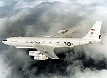
USNS Sea Hunter, an unmanned ocean-going surface vessel is suited for freedom of navigation operations (FONOPS)
ISR is the coordinated and integrated acquisition, processing and provision of timely, accurate, relevant, coherent and assured information and intelligence to support commander's conduct of activities. Land, sea, air and space platforms have critical ISR roles in supporting operations in general.[12][11] By massing ISR assets, an improved clarity and depth of knowledge can be established.[13][14] ISR encompasses multiple activities related to the planning and operation of systems that collect, process, and disseminate data in support of current and future military operations.[15][16][17][18]
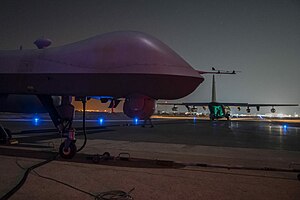
On 28 July 2021 the NDAA budget markup by the House Armed Services Committee sought to retain ISR resources such as the RQ-4 Global Hawk, the E-8 Joint Surveillance Radar and Attack System (JSTARS) which the Air Force is seeking to divest.[19][20][21][22][23] Examples of ISR systems include surveillance and reconnaissance systems ranging from satellites, to crewed aircraft such as the U-2, to uncrewed aircraft systems (UAS)[24][25][26][27] such as the US Air Force's Global Hawk and Predator and the US Army's Hunter and PSST Aerostats, to unmanned ocean-going vessels,[3] to other ground-, air-, sea-, or space-based equipment, to human intelligence teams, or to AI-based ISR systems. [28]
The intelligence data provided by these ISR systems can take many forms, including optical, radar, or infrared images or electronic signals. Effective ISR data can provide early warning of enemy threats as well as enable military forces to increase effectiveness, coordination, and lethality, and demand for ISR capabilities to support ongoing military operations has increased.[15] In December 2021, the US Navy began testing the usefulness and effectiveness of unmanned "saildrones" at recognizing targets of interest on the high seas.[29]
For space-based targeting sensors, in a 2019 Broad Agency Announcement, the US government defined ISR in this case as "a capability for gathering data and information on an object or in an area of interest (AOI) on a persistent, event-driven, or scheduled basis using imagery, signals, and other collection methods. This includes warning (to include ballistic missile activity), targeting analysis, threat capability assessment, situational awareness, battle damage assessment (BDA), and characterization of the operational environment." Persistence was in turn described: "Persistent access provides predictable coverage of an area of interest (AOI). Most space-based intelligence collection capabilities consist of multiple satellites operating in concert, or supplemented by other sensors, when continuous surveillance of an area is desired. Persistent sensors must provide sufficient surveillance revisit timelines to support a weapon strike at any time."[30][31][32][33][34][35][36]
NGA uses Data transformation services (DTS), a program begun in 2018, to convert raw sensor data into a format usable by its mission partners, who are government agencies whose names are classified.[42] In light of the 2022 Russian invasion of Ukraine, NGA has taken operational control of DoD's Project Maven, the AI ISR project for area defense, to identify point targets for ISR.[43] NGA is currently using OREN, the Odyssey GEOINT Edge Node for National System for Geospatial Intelligence, or NGS; the Joint Regional Edge Node (JREN) is on-deck for distributing nearly a petabyte to the Combatant Commands in the next year (for 2023, an increase by a factor of 10).[44][45]
NRO "has a proven track record in [ISR]",[46][47] insists one of the founders of the US Space Force, who defends the capability of the NRO over the ambition of the Space Force to take over the role of ISR.[47][48][49][50] GMTI (ground moving target indicator) data is an objective for Space Force, NGA, and NRO.[51]
ISR at platoon level
Junior (3rd year) and Senior (4th year) cadets at West Point had hands-on experience building and using drones with various tactical capabilities, guided by faculty from the Electrical Engineering and Computer Science departments in tactical applications during Cadet Leadership Development Training in July 2022.[52]
Ukraine's soldiers are using FPV drones on the battlefield, armed with munitions.[53][54]
ISTAR is the process of integrating the intelligence process with surveillance, target acquisition and reconnaissance tasks in order to improve a commander's situational awareness and consequently their decision making. The inclusion of the "I" is important as it recognizes the importance of taking the information from all the sensors and processing it into useful knowledge.
ISTAR can also refer to:
a unit or sub unit with ISTAR as a task (e.g.: an ISTAR squadron)
equipment required to support the task
Variations of ISTAR
There are several variations on the "ISTAR" acronym. Some variations reflect specific emphasis on certain aspects of ISTAR.
Surveillance, target acquisition, and reconnaissance (STAR)
A term used when emphasis is to be placed on the sensing component of ISTAR.
Reconnaissance, surveillance and target acquisition (RSTA)
RSTA is used by the US Army in place of STAR or ISTAR. Also, a term used to identify certain US Army units: for instance, 3rd Squadron, 153rd RSTA. These units serve a similar role to the below mentioned US Marine Corps STA platoons, but on a larger scale.
↑ In 2022 Sea Hunter and three other unmanned surface vessels participated in RIMPAC, which caused requests for additional command and control capabilities for them in naval operations.[1][2][3][4]
Related Research Articles
The Northrop Grumman RQ-4 Global Hawk is a high-altitude, remotely-piloted surveillance aircraft introduced in 2001. It was initially designed by Ryan Aeronautical, and known as Tier II+ during development. The RQ-4 provides a broad overview and systematic surveillance using high-resolution synthetic aperture radar (SAR) and electro-optical/infrared (EO/IR) sensors with long loiter times over target areas. It can survey as much as 40,000 square miles (100,000 km2) of terrain per day, an area the size of South Korea or Iceland.
A surveillance aircraft is an aircraft used for surveillance. They are operated by military forces and other government agencies in roles such as intelligence gathering, battlefield surveillance, airspace surveillance, reconnaissance, observation, border patrol and fishery protection. This article concentrates on aircraft used in those roles, rather than for traffic monitoring, law enforcement and similar activities.
Electromagnetic warfare or electronic warfare (EW) is warfare involving the use of the electromagnetic spectrum or directed energy to control the spectrum, attack an enemy, or impede enemy operations. The purpose of electromagnetic warfare is to deny the opponent the advantage of—and ensure friendly unimpeded access to—the EM spectrum. Electromagnetic warfare can be applied from air, sea, land, or space by crewed and uncrewed systems, and can target communication, radar, or other military and civilian assets.
The National Reconnaissance Office (NRO) is a member of the United States Intelligence Community and an agency of the United States Department of Defense which designs, builds, launches, and operates the reconnaissance satellites of the U.S. federal government, and provides satellite intelligence to several government agencies, particularly signals intelligence (SIGINT) to the NSA, imagery intelligence (IMINT) to the NGA, and measurement and signature intelligence (MASINT) to the DIA. The NRO announced in 2023 that it plans within the following decade to quadruple the number of satellites it operates and increase the number of signals and images it delivers by a factor of ten.
The Northrop Grumman MQ-4C Triton is an American high-altitude long endurance unmanned aerial vehicle (UAV) developed for and flown by the United States Navy as a surveillance aircraft. Together with its associated ground control station, it is an unmanned aircraft system (UAS). Developed under the Broad Area Maritime Surveillance (BAMS) program, the Triton is intended to provide real-time intelligence, surveillance and reconnaissance missions (ISR) over vast ocean and coastal regions, continuous maritime surveillance, conduct search and rescue missions, and to complement the Boeing P-8 Poseidon maritime patrol aircraft.
Power projection in international relations is the capacity of a state to deploy and sustain forces outside its territory. The ability of a state to project its power into an area may serve as an effective diplomatic lever, influencing the decision-making processes and acting as a potential deterrent on other states' behavior.
The reorganization plan of the United States Army is a modernization (2015–2028) and reorganization (2006–2016) plan of the United States Army implemented (2006–2016) under the direction of Brigade Modernization Command. This effort formally began in 2006 when General Peter Schoomaker was given the support to move the Army from its Cold War divisional orientation to a full-spectrum capability with fully manned, equipped and trained brigades; this effort was completed by the end of 2016. It has been the most comprehensive reorganization since World War II and included modular combat brigades, support brigades, and command headquarters, as well as rebalancing the active and reserve components.
The BZK-005 Medium-altitude, long-range UAV is a reconnaissance aircraft designed by Beijing University of Aeronautics & Astronautics and Harbin Aircraft Industry (Group) Co., Ltd. It is used by the PLA Navy and PLA Air Force.
The AeroVironment RQ-20 Puma is an American unmanned aircraft system which is small, battery powered, and hand-launched. Its primary mission is surveillance and intelligence gathering using an electro-optical and infrared camera. It is produced by AeroVironment.
The AeroVironment Switchblade is a miniature loitering munition designed by AeroVironment and used by several branches of the United States military. Small enough to fit in a backpack, the Switchblade launches from a tube, flies to the target area, and crashes into its target while detonating its explosive warhead. The name Switchblade comes from the way the spring-loaded wings are folded up inside a tube and flip out once released.
The ISTAR Battalion is the Portuguese Army unit responsible for centralizing the intelligence, surveillance, target acquisition and reconnaissance (ISTAR) missions.
The Raytheon Coyote is a small, expendable, unmanned aircraft system built by the Raytheon Company, with the capability of operating in autonomous swarms. It is launched from a sonobuoy canister with the wings deploying in early flight phase.
Resolute Eagle is a long-endurance Group 3 unmanned aircraft system (UAS) manufactured and operated by Resolute ISR, Inc. in Howell MI. The Resolute Eagle is a dynamic platform to meet evolving customer requirements. One platform, two configurations. Configuration can be changed in less than 30 minutes. The Standard Fixed Wing configuration launches on a low-pressure Pneumatic launcher and recovers via a Belly-skid landing utilizing a Kevlar skid plate. The Resolute Eagle Hybrid VTOL utilizes two mounted battery-powered booms with four propellers, so it can take off and land like a helicopter—but still, cruise for long distances like a plane. Resolute Eagle utilizes an Applied Navigation Quattro autopilot to transition from Standard Fixed Wing to VTOL configuration.
The Bramor C4EYE is a tactical reconnaissance UAV classified as a NATO class 1 mini tactical drone with less than 5 kg MTOW. It was developed and built by C-Astral Aerospace Ltd from Ajdovščina in Slovenia.
Space Delta 7 is a United States Space Force unit responsible for Intelligence, Surveillance and Reconnaissance (ISR) for the United States Space Force. The delta provides actionable and time-sensitive intelligence for space domain operations including detection, characterization and targeting of adversary space capabilities. The unit employs a variety of fixed and mobile sensors across the globe operated by intelligence professionals to enable its mission to gain and maintain information dominance in the space domain in the execution of National Defense Strategy priorities. It is headquartered at Peterson Space Force Base.
No. 1 Intelligence, Surveillance, and Reconnaissance Wing is a wing of the Royal Air Force and is part of the ISTAR Force in No. 1 Group based at RAF Waddington. 1 ISR Wing is responsible for producing intelligence from imagery intelligence and electronic surveillance.
The Space Development Agency (SDA) is a United States Space Force direct-reporting unit tasked with deploying disruptive space technology. A primary focus is space-based missile defense using large global satellite constellations made up of industry-procured low-cost satellites. The SDA has been managed by the United States Space Force since October 2022. By September 2023 the SDA had 23 satellites on orbit. SDA targets to have at least 1,000 satellites in low Earth orbit by 2026.
Joint All-Domain Command and Control or JADC2 is the concept that the Department of Defense has developed to connect sensors from all branches of the armed forces into a § unified network powered by artificial intelligence. These branches include the Air Force, Army, Marine Corps, and Navy, as well as Space Force.
WZ-8, is a supersonic unmanned aerial vehicle produced by Aviation Industry Corporation of China (AVIC). Introduced during China's 70th anniversary military parade, the drone is intended to conduct strategic aerial reconnaissance across southeast Asia, particularly Taiwan and South Korea. Its reconnaissance capabilities reportedly include electro-optical imaging, synthetic-aperture radar, and other sensors. Some have suggested the drone will be weaponized to provide strategic anti-access/area denial capabilities. The drone cannot take off under its own power, instead it is air-launched from a Xi'an H-6M mothership once the H-6 reaches a prescribed speed and altitude.
The SQA eVTOL is a tactical reconnaissance UAV classified as a NATO class 1 mini tactical drone with less than 15kg MTOW. It was developed and built by a world leader in UAS production C-Astral Aerospace Ltd from Ajdovscina in Slovenia. The development is based on the combat proven and NATO operated Bramor and Atlas family of legacy UAS.
↑ Rear Admiral Patrick Piercey, U.S. Navy (Retired) (Sep 2023) Planning for the Next War Must Be a Mixture of Art & Science "In recent decades, military planning has leaned more heavily on science than art, but success in a peer-level fight will depend on commander’s intent and the art of warfare". Proceedings of US Naval Institute vol 149 (9) #1,447
↑ AJP-3.15(A) NATO Allied Joint Doctrine for Countering – Improvised Explosive Devices.
↑ Lauren Williams (19 Oct 2022) The U.S. Army Is Testing A Data Platform Just For Intel Officers "We are testing an Army Intelligence Data Platform. So essentially a system that will ingest all of the Army's intel data—data from the intel community, commercial data, whatever data sources our intel professionals may need or want" —Mark Kitz PEO Intelligence, Electronic Warfare and Sensors (IEWS)
This page is based on this Wikipedia article Text is available under the CC BY-SA 4.0 license; additional terms may apply. Images, videos and audio are available under their respective licenses.