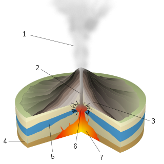
A volcano is a rupture in the crust of a planetary-mass object, such as Earth, that allows hot lava, volcanic ash, and gases to escape from a magma chamber below the surface.

Mauna Loa is one of five volcanoes that form the Island of Hawaii in the U.S. state of Hawaii in the Pacific Ocean. The largest subaerial volcano in both mass and volume, Mauna Loa has historically been considered the largest volcano on Earth, dwarfed only by Tamu Massif. It is an active shield volcano with relatively gentle slopes, with a volume estimated at 18,000 cubic miles (75,000 km3), although its peak is about 125 feet (38 m) lower than that of its neighbor, Mauna Kea. Lava eruptions from Mauna Loa are silica-poor and very fluid, and tend to be non-explosive.

Volcanology is the study of volcanoes, lava, magma and related geological, geophysical and geochemical phenomena (volcanism). The term volcanology is derived from the Latin word vulcan. Vulcan was the ancient Roman god of fire.

A volcanologist, or volcano scientist, is a geologist who focuses on understanding the formation and eruptive activity of volcanoes. Volcanologists frequently visit volcanoes, sometimes active ones, to observe and monitor volcanic eruptions, collect eruptive products including tephra, rock and lava samples. One major focus of inquiry in recent times is the prediction of eruptions to alleviate the impact on surrounding populations and monitor natural hazards associated with volcanic activity. Geologists who research volcanic materials that make up the solid Earth are referred to as igneous petrologists.

Nevado del Ruiz, also known as La Mesa de Herveo is a volcano on the border of the departments of Caldas and Tolima in Colombia, about 129 km (80 mi) west of the capital city Bogotá. It is a stratovolcano composed of many layers of lava alternating with hardened volcanic ash and other pyroclastic rocks. Volcanic activity at Nevado del Ruiz began about two million years ago, since the Early Pleistocene or Late Pliocene, with three major eruptive periods. The current volcanic cone formed during the present eruptive period, which began 150,000 years ago.

Kīlauea is an active shield volcano in the Hawaiian Islands. Located along the southeastern shore of the Big Island of Hawaii, the volcano is between 210,000 and 280,000 years old and emerged above sea level about 100,000 years ago. Historically, it is the most active of the five volcanoes that together form the island of Hawaii. Kīlauea is also one of the most active volcanoes on Earth, with the most recent eruption from June 7-19, 2023 after a series of earthquakes, when multiple vents erupted lava within Halemaʻumaʻu, a pit crater in the volcano's summit caldera, and building a fissure cinder cone approximately 40 m (130 ft) high. Halema'uma'u has been the sole eruptive area of Kīlauea since December, 2020 with intermittent lava effusion from then to March 7, 2023, followed by a 90 day pause.

A phreatic eruption, also called a phreatic explosion, ultravulcanian eruption or steam-blast eruption, occurs when magma heats ground water or surface water. The extreme temperature of the magma causes near-instantaneous evaporation of water to steam, resulting in an explosion of steam, water, ash, rock, and volcanic bombs. At Mount St. Helens in Washington state, hundreds of steam explosions preceded the 1980 Plinian eruption of the volcano. A less intense geothermal event may result in a mud volcano.

The Hawaiian Volcano Observatory (HVO) is an agency of the U.S. Geological Survey (USGS) and one of five volcano observatories operating under the USGS Volcano Hazards Program. Based in Hilo, Hawaii, the observatory monitors six Hawaiian volcanoes: Kīlauea, Mauna Loa, Kamaʻehuakanaloa, Hualālai, Mauna Kea, and Haleakalā, of which, Kīlauea and Mauna Loa are the most active. The observatory has a worldwide reputation as a leader in the study of active volcanism. Due to the relatively non-explosive nature of Kīlauea's volcanic eruptions for many years, scientists have generally been able to study ongoing eruptions in proximity without being in extreme danger.

Vog is a form of air pollution that results when sulfur dioxide and other gases and particles emitted by an erupting volcano react with oxygen and moisture in the presence of sunlight. The word is a portmanteau of the words "volcanic" and "smog". The term is in common use in the Hawaiian islands, where the Kīlauea volcano, on the Island of Hawaiʻi (the "Big Island"), erupted continuously between 1983 and 2018. Based in June 2008 measurements, Kīlauea emits 2,000–4,000 tons of sulfur dioxide (SO2) every day.
The Decade Volcanoes are 16 volcanoes identified by the International Association of Volcanology and Chemistry of the Earth's Interior (IAVCEI) as being worthy of particular study in light of their history of large, destructive eruptions and proximity to densely populated areas. The Decade Volcanoes project encourages studies and public-awareness activities at these volcanoes, with the aim of achieving a better understanding of the volcanoes and the dangers they present, and thus being able to reduce the severity of natural disasters.

A Hawaiian eruption is a type of volcanic eruption where lava flows from the vent in a relatively gentle, low level eruption; it is so named because it is characteristic of Hawaiian volcanoes. Typically they are effusive eruptions, with basaltic magmas of low viscosity, low content of gases, and high temperature at the vent. Very small amounts of volcanic ash are produced. This type of eruption occurs most often at hotspot volcanoes such as Kīlauea on Hawaii's big island and in Iceland, though it can occur near subduction zones and rift zones. Hawaiian eruptions may occur along fissure vents, such as during the eruption of Mauna Loa in 1950, or at a central vent, such as during the 1959 eruption in Kīlauea Iki Crater, which created a lava fountain 580 meters (1,900 ft) high and formed a 38-meter cone named Puʻu Puaʻi. In fissure-type eruptions, lava spurts from a fissure on the volcano's rift zone and feeds lava streams that flow downslope. In central-vent eruptions, a fountain of lava can spurt to a height of 300 meters or more.

Halemaʻumaʻu is a pit crater within the much larger Kīlauea Caldera at the summit of Kīlauea volcano on island of Hawaiʻi. The roughly circular crater was 770 meters (2,530 ft) x 900 m (2,950 ft) before collapses that roughly doubled the size of the crater after May 3, 2018. Following the collapses of 2018, the bottom of Halemaʻumaʻu was roughly 600 m (2,000 ft) below the caldera floor. Halemaʻumaʻu is home to Pele, goddess of fire and volcanoes, according to the traditions of Hawaiian religion. Halemaʻumaʻu means "house of the ʻāmaʻu fern".

In late October 2010, Mount Merapi in Central Java, Indonesia, began an increasingly violent series of eruptions that continued into November. Seismic activity around the volcano increased from mid-September onwards, culminating in repeated outbursts of lava and ashes. Large eruption columns formed, causing numerous pyroclastic flows down the heavily populated slopes of the volcano. Merapi's eruption was the largest since the 1870s.

Volcanic ash consists of fragments of rock, mineral crystals, and volcanic glass, produced during volcanic eruptions and measuring less than 2 mm (0.079 inches) in diameter. The term volcanic ash is also often loosely used to refer to all explosive eruption products, including particles larger than 2 mm. Volcanic ash is formed during explosive volcanic eruptions when dissolved gases in magma expand and escape violently into the atmosphere. The force of the gases shatters the magma and propels it into the atmosphere where it solidifies into fragments of volcanic rock and glass. Ash is also produced when magma comes into contact with water during phreatomagmatic eruptions, causing the water to explosively flash to steam leading to shattering of magma. Once in the air, ash is transported by wind up to thousands of kilometres away.

The 2018 lower Puna eruption was a volcanic event on the island of Hawaiʻi, on Kīlauea volcano's East Rift Zone that began on May 3, 2018. It is related to the larger eruption of Kīlauea that began on January 3, 1983, though some volcanologists and USGS scientists have discussed whether to classify it as a new eruption. Outbreaks of lava fountains up to 300 feet (90 m) high, lava flows, and volcanic gas in the Leilani Estates subdivision were preceded by earthquakes and ground deformation that created cracks in the roads.

Laze is acid rain and air pollution arising from steam explosions and large plume clouds containing extremely acidic condensate, which occur when molten lava flows enter cold oceans. The term laze is a portmanteau of lava and haze.
An Ashfall advisory is a weather advisory issued by the National Weather Service of the United States. Ashfall advisories are issued when there is a likely future or present occurrence of ash rain caused by a large plume of suspended airborne ash, typically caused by large fires or volcanic activity. The National Weather service map color is Dark Grey.

Claire Judith Horwell is a professor of Geohealth in the Department of Earth Sciences and Institute of Hazard, Risk and Resilience at Durham University and the founding Director of the International Volcanic Health Hazard Network (IVHHN). She studies the health hazards of natural and industrial mineral dusts and community protection.

The 2022 eruption of Mauna Loa was an episode of eruptive volcanic activity at Mauna Loa, the world's largest active volcano, located on Hawaiʻi island, Hawaiʻi. Mauna Loa began to erupt shortly before midnight HST on November 27, 2022, when lava flows emerged from fissure vents in Moku‘āweoweo. It marked the first eruption at the volcano in 38 years. The eruption ended on December 13, 2022, after more than two weeks.


