Fort William is a town in Lochaber in the Scottish Highlands, located on the eastern shore of Loch Linnhe. As of the 2011 Census, Fort William had a population of 10,459, making it the second largest settlement in the Highland council area, and the second largest settlement in the whole of the Scottish Highlands; only the city of Inverness has a larger population.

The Great Glen, also known as Glen Albyn or Glen More, is a glen in Scotland running for 62 miles (100 km) from Inverness on the edge of Moray Firth, in an approximately straight line to Fort William at the head of Loch Linnhe. It follows a geological fault known as the Great Glen Fault, and bisects the Scottish Highlands into the Grampian Mountains to the southeast and the Northwest Highlands to the northwest.
Lochcarron is a village, community and civil parish in the Wester Ross area of Highland, Scotland. It has a population of 923.

Kinlochbervie is a scattered harbour village in the north west of Sutherland, in the Highland region of Scotland. It is the most northerly port on the west coast of Scotland.

Drumnadrochit is a village in the Highland local government council area of Scotland, lying near the west shore of Loch Ness at the foot of Glen Urquhart. The village is close to several neighbouring settlements: the villages of Milton to the west, Kilmore to the east and Lewiston to the south. The villages act as a centre for regional tourism beside Loch Ness, as well as being a local economic hub for the nearby communities.
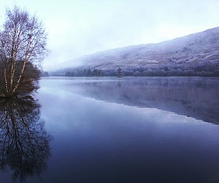
Loch Oich is a freshwater loch in the Highlands of Scotland which forms part of the Caledonian Canal, of which it is the highest point. This narrow loch lies between Loch Ness and Loch Lochy in the Great Glen. It is fed by the River Garry from the west, and feeds the River Oich from its northern end. The Laggan locks separate it from Loch Lochy.
Laggan is a small village in the Great Glen, in the Highland region of Scotland. The older, longer Gaelic name is Lagan Achaidh Droma, "hollow at the field of the ridge".

The Great Glen Way is a long distance path in Scotland. It follows the Great Glen, running from Fort William in the southwest to Inverness in the northeast, covering 125 kilometres (78 mi). It was opened in 2002, and is designated as one of Scotland's Great Trails by NatureScot. The Great Glen Way is generally walked from southwest to northeast to follow the direction of the prevailing wind. It can be walked in 5–7 days, or cycled in 2–3 days. The trail is maintained and improved by the Great Glen Ways partnership, which consists of Highland Council, Scottish Canals and Forestry and Land Scotland. About 30,000 people use the path every year, of whom about 4,500 complete the entire route.

Caol is a village near Fort William, in the Highland council area of Scotland. It is about 1+1⁄4 miles north of Fort William town centre, on the shore of Loch Linnhe, and within the parish of Kilmallie.

Tighnabruaich; is a village on the Cowal peninsula, on the western arm of the Kyles of Bute in Argyll and Bute, Scotland. In 2011 the population was 660. It is west of Glasgow and north of the Isle of Arran.
Glengarry Shinty Club is a shinty team from Invergarry, Inverness-shire, Scotland. The club has played in its present form since 1976. There is one senior team, competing in North Division Two . The club also runs a highly successful women's team.

The Invergarry and Fort Augustus Railway was a branch-line railway built in Scotland, connecting the named places with the main line at Spean Bridge. It opened in 1903.
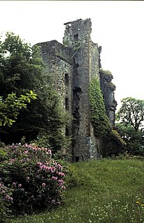
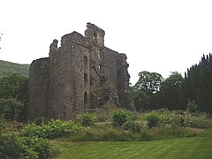
Invergarry Castle in the Scottish Highlands was the seat of the Chiefs of the Clan MacDonell of Glengarry, a powerful branch of the Clan Donald.
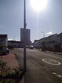
Deaconsbank is a neighbourhood in the Scottish city of Glasgow. It is situated south of the River Clyde. The main feature of the area, which falls into the Greater Pollok ward of Glasgow City Council and directly borders the East Renfrewshire council region, is an estate of around 639 private houses built in the late 1970s by Barratt Developments, prior to which the area was open farmland. Deaconsbank is bordered by the M77 motorway to the west and by Rouken Glen Park and golf course to the east. The northern parts of the suburban town of Newton Mearns are a short distance to the south, as is Patterton railway station.

Ben Tee is a Scottish mountain situated in the Lochaber area of the Highland council area, some 15 kilometres north of Spean Bridge. It is rated as one of the best of Scotland's smaller mountains with Hamish Brown saying:
Ben Tee is such a shapely cone that it is instantly recognisable from anywhere around the Great Glen or along the Garry. Its isolated situation makes it one of Scotland’s finest summit viewpoints.
Aberchalder railway station served the village of Aberchalder, in the county of Inverness-shire in Scotland.

Loch Ness is a large freshwater loch in the Scottish Highlands extending for approximately 37 kilometres southwest of Inverness. It takes its name from the River Ness, which flows from the northern end. Loch Ness is best known for alleged sightings of the cryptozoological Loch Ness Monster, also known affectionately as "Nessie". It is one of a series of interconnected, murky bodies of water in Scotland; its water visibility is exceptionally low due to a high peat content in the surrounding soil. The southern end connects to Loch Oich by the River Oich and a section of the Caledonian Canal. The northern end connects to Loch Dochfour via the River Ness, which then ultimately leads to the North Sea via the Moray Firth.

The River Garry in Invernessshire is a long river punctuated by a series of long Lochs, in Lochaber. Many of the Lochs are part of a 1960s hydroelectricity scheme. The river begins in The Rough Bounds, and proceeds into Loch Quoich, from where it heads east until it joins the River Kingie at the Kingie Pool. From there it flows into Loch Poulary, and thence to Loch Garry. The final section is 3.5 miles (5.6 km) long, and runs into Loch Oich just east of the village of Invergarry, through which it runs. Invergarry is the near the site of the 17th century Invergarry Castle; a website showing the village and the river in detail from the air exists at www.myglengarry.com.

Glenurquhart or Glen Urquhart is a glen running to the west of the village of Drumnadrochit in the Highland council area of Scotland.
Invergarry Railway Station is situated at the southern end of Loch Oich, on the eastern side, and not far from the Laggan swing bridge over the Caledonian canal. It is therefore 2 miles from the village of Invergarry.