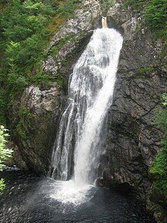
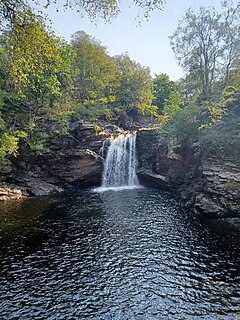
| Inversnaid Falls | |
|---|---|
 Inversnaid Falls, Loch Lomond, Scotland | |
 | |
| Location | Stirling, Scotland |
| Coordinates | 56°14′33″N4°41′02″W / 56.242461°N 4.683856°W Coordinates: 56°14′33″N4°41′02″W / 56.242461°N 4.683856°W |
| Inversnaid Falls | |
|---|---|
| Inversnaid Falls, Loch Lomond, Scotland | |
| | |
| Location | Stirling, Scotland |
| Coordinates | 56°14′33″N4°41′02″W / 56.242461°N 4.683856°W Coordinates: 56°14′33″N4°41′02″W / 56.242461°N 4.683856°W |

A waterfall is a point in a river or stream where water flows over a vertical drop or a series of steep drops. Waterfalls also occur where meltwater drops over the edge of a tabular iceberg or ice shelf.

Franklin is a town in and the county seat of Macon County, North Carolina, United States. It is situated within the Nantahala National Forest. The population was reported to be 4,175 in the 2020 census, an increase from the total of 3,845 tabulated in 2010.

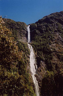
Angel Falls is a waterfall in Venezuela. It is the world's tallest uninterrupted waterfall, with a height of 979 metres (3,212 ft) and a plunge of 807 m (2,648 ft). The waterfall drops over the edge of the Auyán-tepui mountain in the Canaima National Park, a UNESCO World Heritage site in the Gran Sabana region of Bolívar State. The height figure, 979 m (3,212 ft), mostly consists of the main plunge but also includes about 400 metres (1,300 ft) of sloped cascade and rapids below the drop and a 30-metre-high (100 ft) plunge downstream of the talus rapids.
Sutherland Falls is a waterfall near Milford Sound in New Zealand's South Island. At 580 metres the falls were long believed to be the tallest waterfall in New Zealand. Terror Falls, in the Poseidon Valley (nearby), are 750m, and Browne Falls cascades 843 metres down a mountainside in Doubtful Sound, leading some to view that as the tallest.

The Stirling council area is one of the 32 council areas of Scotland, and has a population of about 94,330. It was created under the Local Government etc (Scotland) Act 1994 with the boundaries of the Stirling district of the former Central local government region, and it covers most of Stirlingshire and the south-western portion of Perthshire. Both counties were abolished for local government purposes under the Local Government (Scotland) Act 1973.

The Falls of Clyde is the collective name of four linn on the River Clyde near New Lanark, South Lanarkshire, Scotland. The Falls of Clyde comprise the upper falls of Bonnington Linn, Corra Linn, Dundaff Linn, and the lower falls of Stonebyres Linn. Corra Linn is the highest, with a fall of 26 metres (84 ft). Bonnington Linn, Corra Linn and Dundaff Linn are above New Lanark and located within the Falls of Clyde Reserve managed by the Scottish Wildlife Trust, a national nature conservation charity. Stonebyres Linn is located several miles downstream from the reserve and New Lanark.
Acharn is a hamlet in the Kenmore parish of the Scottish council area of Perth and Kinross. It is situated on the south shore of Loch Tay close to its eastern end. The hamlet was built in the early 19th century to house workers from the surrounding estates. A watermill was constructed to harness the power of the nearby Acharn Burn, and this was converted into a craft centre in the 1970s, and later into a private residence. There is a bridge in the middle that goes over the Acharn burn.
The Fall of Foyers is a waterfall on the River Foyers, which feeds Loch Ness, in Highland, Scotland, United Kingdom. It is located on the lower portion of the River Foyers, and drops 165 feet (50 m).

Inversnaid is a small rural community on the east bank of Loch Lomond in Scotland, near the north end of the loch. It has a pier and a hotel, and the West Highland Way passes through the area. A small passenger ferry runs from Inversnaid to Inveruglas on the opposite shore of the loch, and also to Tarbet. There is a seasonal ferry that also operates between Ardlui and Ardleish as well, which is a walkable distance from Inversnaid. To reach Inversnaid by road involves a 15-mile (24-kilometre) route from Aberfoyle. Nearby is an alleged hideout of Rob Roy MacGregor known as Rob Roy's Cave. The cave is difficult to access, and is best seen from Loch Lomond, where there is white paint indicating the location of the hideout.
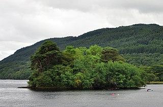
Inveruglas Isle is a small uninhabited island within Loch Lomond, and lies off the shore at Inveruglas opposite Inversnaid at the north end of the loch. It is opposite the Loch Sloy powerstation.

The Teviot Falls is a plunge waterfall in the Darling Downs region of Queensland, Australia.
Falls of Clyde may refer to:
Achness Falls, also known as the Achness Waterfall or Cassley Falls, is a waterfall located on the River Cassley in Sutherland, Scotland, near Rosehall and Invercassley. Its name is derived from the Scottish Gaelic Ach-an-eas, the "field of the waterfall".

Eas a' Chrannaig also known as the Glenashdale Falls is a waterfall on the island of Arran, Scotland. There are a series of falls on the Glenashdale Burn, which flows from moorland near the summit of Tighvein eastwards towards Whiting Bay, from which there is a tourist trail leading some 4 kilometres (2.5 mi) up Glenashdale.
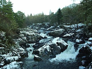
Falls of Falloch is a waterfall and local beauty spot on the river Falloch off the A82. It is 7 km (4 mi) south-west of the village of Crianlarich in the county of Stirling in Scotland. It is also on the West Highland Way.

The Great Trossachs Path is a 48-kilometre (30 mi) long-distance footpath through the Trossachs, in the Stirling council area of Scotland. It runs between Callander in the east and Inversnaid on the banks of Loch Lomond in the west, passing along the northern shores of Loch Katrine and Loch Arklet. The path is suitable for walkers and cyclists; much of the route is also suitable for experience horse riders, although the middle section along the shoreline of Loch Katrine is tarmacked and so may not be ideal for horses.
![]() Media related to Inversnaid Falls at Wikimedia Commons
Media related to Inversnaid Falls at Wikimedia Commons
| | This Scottish location article is a stub. You can help Wikipedia by expanding it. |