
The Lower Mainland is a geographic and cultural region of the mainland coast of British Columbia that generally comprises the regional districts of Metro Vancouver and the Fraser Valley. Home to approximately 3.05 million people as of the 2021 Canadian census, the Lower Mainland contains sixteen of the province's 30 most populous municipalities and approximately 60% of the province's total population.

Richmond is a city in the coastal Lower Mainland region of British Columbia, Canada. It occupies almost the entirety of Lulu Island, between the two estuarine distributaries of the Fraser River. Encompassing the adjacent Sea Island and several other smaller islands and uninhabited islets to its north and south, it neighbours Vancouver and Burnaby on the Burrard Peninsula to the north, New Westminster and Annacis Island to the east, Delta to the south, and the Strait of Georgia to the west.

The Fraser River is the longest river within British Columbia, Canada, rising at Fraser Pass near Blackrock Mountain in the Rocky Mountains and flowing for 1,375 kilometres (854 mi), into the Strait of Georgia just south of the City of Vancouver. The river's annual discharge at its mouth is 112 cubic kilometres (27 cu mi) or 3,550 cubic metres per second (125,000 cu ft/s), and each year it discharges about 20 million tons of sediment into the ocean.
The Fraser Valley is a geographical region in southwestern British Columbia, Canada and northwestern Washington State. It starts just west of Hope in a narrow valley encompassing the Fraser River and ends at the Pacific Ocean stretching from the North Shore Mountains, opposite the city of Vancouver BC, to just south of Bellingham, Washington.
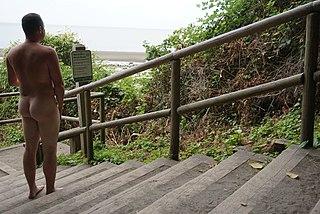
Wreck Beach is a clothing-optional beach located in Pacific Spirit Regional Park, which is in turn part of the University Endowment Lands just west of Vancouver, British Columbia, Canada. The clothing-optional section is clearly marked with signs and stretches approximately 6.7 kilometres or 4.2 miles from Acadia Beach, in the north, to the Booming Grounds Creek on the north arm of the Fraser River. The park is administered by the Greater Vancouver Regional District (GVRD), though Indigenous claims are repeatedly asserted, especially by the Musqueam Nation.

The Strait of Georgia or the Georgia Strait is an arm of the Salish Sea between Vancouver Island and the extreme southwestern mainland coast of British Columbia, Canada, and the extreme northwestern mainland coast of Washington, United States. It is approximately 240 kilometres (150 mi) long and varies in width from 20 to 58 kilometres. Along with the Strait of Juan de Fuca and Puget Sound, it is a constituent part of the Salish Sea.

The Burrard Peninsula is a peninsula in the Lower Mainland region of British Columbia, Canada, bounded by the Burrard Inlet to the north, the Georgia Strait to the west, the North Arm of Fraser River to the south, and the Pitt River and Douglas Island to the east. The City of Vancouver occupies almost all of the western half of the peninsula, and the Cities of Burnaby and New Westminster occupy more than half of the eastern half. At its northeastern end, the peninsula is connected to the Eagle Mountain and Mount Burke of the Coast Mountains via a small isthmus at the center of the Tri-Cities.
Steveston, founded in the 1880s, is a neighbourhood of Richmond in Metro Vancouver. On the southwest tip of Lulu Island, the village is a historic port and salmon canning centre at the mouth of the South Arm of the Fraser River. The early 1900s style architecture attracts both the film and tourism industries.

The following is an alphabetical list of articles related to the Canadian province of British Columbia.

Ladner is a part of the City of Delta, British Columbia, Canada, and a suburb of Vancouver, British Columbia. It was created as a fishing village on the banks of the Fraser River.
Roberts Bank is an undersea bank in the Strait of Georgia on the south side of the estuary of the Fraser River approximately 35 kilometres (22 mi) south of Vancouver, British Columbia, Canada. Located between the South Arm of the Fraser River and Tsawwassen, it is significant as both a transport hub because of the Tsawwassen Ferry Terminal and port because of the Roberts Bank Superport, and as an area with important wetland habitat. The term properly refers to the shallows offshore from the Superport and wetland.

The Regional District of Comox-Strathcona was a regional district of British Columbia, Canada, from 1967 to 2008. On February 15, 2008, the regional district was abolished and replaced by two successor regional districts, Comox Valley and Strathcona.

The Musqueam Indian Band is a First Nations band government in the Canadian province of British Columbia. It is the only First Nations band whose reserve community lies within the boundaries of the City of Vancouver.

Lulu Island is the name of the largest island in the estuary of the Fraser River, located south of Vancouver, British Columbia, Canada, and the second-most populous island in British Columbia, after Vancouver Island. The city of Richmond occupies most of the island, while a small section at the eastern tip, known as Queensborough, is part of the city of New Westminster.

Miracle Beach Provincial Park is a provincial park on the eastern shore of Vancouver Island in British Columbia, Canada. Located between Comox and Campbell River, the park includes a foreshore area in the Strait of Georgia, much of the Black Creek estuary, and a forested area. According to its Master Plan, it fulfills primarily a recreational role with a focus on beach play, picnicking, nature appreciation, and camping, and a secondary conservation role with a focus on the natural shoreline and estuary. In support of its recreational focus the park is developed with a day-use parking area with accessible trails leading to the shoreline and a camping area with 200 drive-in sites. The park is also hosts a nature centre building and a sheltered group picnic shelter. Vegetation in the park is typical for the region's second-growth forests with Douglas-fir most prominent. Common associates include Western hemlock, Sitka spruce, red alder and bigleaf maple. Salal and sword fern are the most abundant shrub. Black Creek, which flows through the park, is a spawning area for coho salmon.

Sea Island is an island in the Fraser River estuary in the city of Richmond, British Columbia. It is located south of the city of Vancouver and north and west of Lulu Island. Sea Island is the home to Vancouver International Airport (YVR), a nature conservation area, and a permanent resident population of 814, most of which live in the neighbourhood of Burkeville. A small part of the island is under the administration of the Musqueam Indian Band.
Deas Island is a peninsula in the south arm of the Fraser River between Delta, British Columbia and Richmond, British Columbia, Canada. It is home to a regional park approximately 300 acres (120 ha) in size; and has three historic buildings: Burrvilla, a stately Victorian home; Inverholme, a one-room schoolhouse; and the Delta Agricultural Hall. Between 1895 and the 1940s, the peninsula had a small Greek settlement with a population of about 80 at its peak.
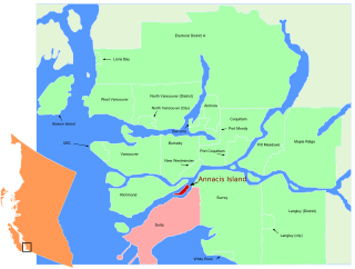
Annacis Island is a narrow island under the jurisdiction of City of Delta in Lower Mainland, British Columbia, located just downstream of the south arm of the Fraser River bifurcation between Lulu Island to the north and the Delta peninsula to the south. The island is now mostly an industrial zone, and contains one of Metro Vancouver's secondary wastewater treatment plants, the Annacis Island Wastewater Treatment Plant. The island is also home to the British Columbia Institute of Technology's Annacis Island campus.

Mitchell Island is an island in the North Arm of the Fraser River in British Columbia, Canada, located between the cities of Vancouver and Richmond. It is crossed by the Knight Street Bridge, which is one of the main bridges between the City of Vancouver and Richmond.


